Headwaters To Confluence With Gray Wolf River River Run
Community Reviews
Been here? Share the conditions.
Reviews, ratings & photos are added in the free Snoflo iOS app — rate a spot, tag the conditions, and your visit is verified by location. Add or manage your reviews from the app.
Headwaters To Confluence With Gray Wolf River
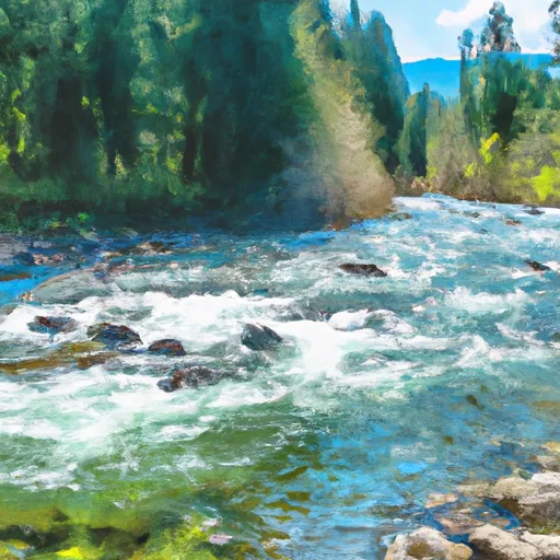
The river rapids and obstacles that paddlers will encounter on this run include continuous class III rapids, tight boulder gardens, and steep chutes. Some of the notable rapids on this run include Zig Zag, S-Turn, and The Toilet Bowl. These rapids require technical paddling skills and a good understanding of river hydraulics. Paddlers should be prepared for a challenging and exhilarating experience on this river run.
There are specific regulations to the area that paddlers must be aware of. A permit is required to access the Olympic National Forest, where the river run is located. The permit can be obtained through the National Forest Service website. Additionally, paddlers must follow Leave No Trace principles and pack out all trash and waste.
In conclusion, the Whitewater River Run in Washington is a challenging and exciting adventure for whitewater enthusiasts. Paddlers must be prepared for a technical and demanding experience on the river. It is important to follow regulations and Leave No Trace principles to preserve the natural beauty of the area.
Plan your run down to the hour
Same weather feed Snoflo's iOS app uses -- updated continuously from NOAA / yr.no. Watch the precipitation column on the meteogram; rain ahead of a run typically lifts flows 12-48 hours later depending on the basin.
Next 5 days, hour by hour
Temperature line with weather symbols on top, snow + rain accumulation as columns, humidity as a dotted line.
5-day forecast table
Every 3 hours, broken out across temperature, snow, rain, humidity, and wind. Each cell is colour-coded relative to the column min/max.
| Time | Condition | Temp (°F) | Snow (in) | Rain (in) | Humidity (%) | Wind (mps) | Wind dir |
|---|---|---|---|---|---|---|---|
| Loading detailed forecast… | |||||||
15-day temperature & precipitation
Daily temperatures, snow, and rain projected over the next two weeks -- the upstream story that drives next week's flows.
Regional streamflow levels
USGS streamgauges around Headwaters To Confluence With Gray Wolf River -- useful for spotting upstream pulses and gauging which tributary is contributing what.
| Streamgauge | Discharge | View |
|---|---|---|
| Dungeness River Near Sequim | 104 cfs | → |
| Big Quilcene River Below Diversion Nr Quilcene | 26 cfs | → |
| Duckabush River Near Brinnon | 49 cfs | → |
| Elwha River Above Lake Mills Nr Port Angeles | 725 cfs | → |
| Elwha River At Mcdonald Br Near Port Angeles | 330 cfs | → |
| Nf Skokomish R Bl Staircase Rpds Nr Hoodsport | 39 cfs | → |
Plan a longer trip
The closest boat launches, other paddle runs, and campgrounds so a day on the water can grow into a full weekend.
Other river runs
- Headwaters And Includes All Tributaries To Confluence With Gray Wolf River
- Headwaters- Includes All Tributaries To Confluence With Dosewallips River
- Headwaters At About 6000 Ft. In Basins On The North Side Of Gray Wolf Pass And Includes All Tributaries Within The Park To Eastern Boundary Of Olympic National Forest
Campgrounds
- Falls Camp Primitive Camping
- Lower Cameron Primitive Camping
- Royal Lake
- Camp Ellis Primitive Camping
- Gladys Lake Primitive Camping
- Moose Lake Primitive Camping
Parks
Whitewater safety
- Check the flow before you run
- Use the linked-gauge card and Regional Flow panel above. Class ratings change with flow -- a Class III at low water can become Class IV+ at high water.
- Know your skill ceiling
- Pick runs comfortably below your ceiling. Cold-water and big-water runs raise the consequences of any mistake.
- Wear the right gear
- Helmet, PFD, drysuit / wetsuit when water is below 60°F. Throw bag, knife, and whistle on your person, not in the boat.
- Scout, set safety, and run with a team
- Scout new rapids on foot, set safety with throw bags above the consequence pool, and run with at least one other competent paddler.
- Respect the river
- Strainers, undercuts, low-head dams, and wood can kill at any class rating. When in doubt, portage.
Set push alerts in the Snoflo app
Save Headwaters To Confluence With Gray Wolf River as a favorite, set a discharge threshold (e.g. "alert me when flow hits 600 cfs"), and the iOS app pushes the moment the linked gauge crosses.
About Headwaters To Confluence With Gray Wolf River
What's the optimal flow for Headwaters To Confluence With Gray Wolf River?
The optimal flow depends on the section and the craft. Check the Run Details panel for the linked gauge and current status.
How fresh is the cfs reading on this page?
The linked USGS streamgauge reports continuously (every 15 minutes); Snoflo refreshes throughout the day. Hover the streamflow sparkline to read individual datapoints.
What's the whitewater class?
See the Run Details panel for the class rating Snoflo tracks for this run. Class ratings change with flow -- a Class III at low water can become Class IV in high water.
Where do I put in / take out?
Tap Directions in the hero above to open driving directions to the put-in. For shuttle planning, check the Nearby Boat Launches panel and the river run operator's site.
Can I get alerts when flows hit the optimal range?
Yes -- alerts are managed in the Snoflo iOS app. Favorite this run, set a discharge threshold, and you'll get a push the moment the gauge crosses.
Other runs near here
Snoflo-tracked paddle runs within driving distance of Headwaters To Confluence With Gray Wolf River.