Begins Where The Lost River Becomes The Cacapon River To Wardensville River Run
Community Reviews
Been here? Share the conditions.
Reviews, ratings & photos are added in the free Snoflo iOS app — rate a spot, tag the conditions, and your visit is verified by location. Add or manage your reviews from the app.
Begins Where The Lost River Becomes The Cacapon River To Wardensville
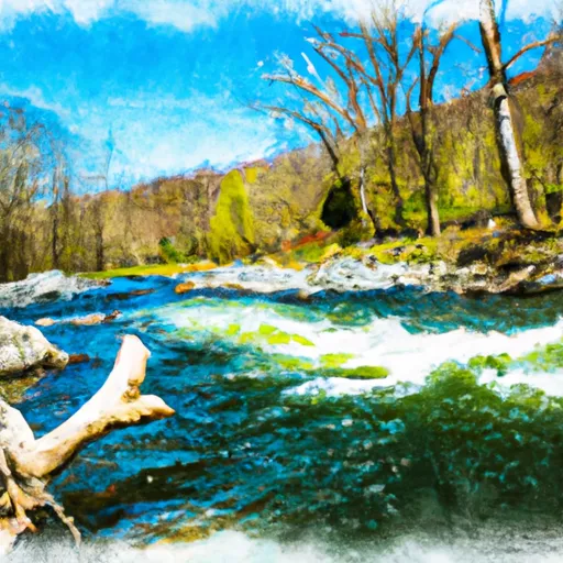
Specific regulations apply to this area, including a catch-and-release policy for all fish caught in the river. Additionally, all boats must have proper safety equipment, including personal flotation devices (PFDs) for all passengers. The National Park Service also recommends paddlers to avoid this section of the river during high water levels, as it can become dangerous and difficult to navigate.
In summary, the Whitewater River Run is a challenging and exciting 10-mile section of river that requires skilled paddling and proper safety equipment. With Class II-III rapids and several large boulders and eddies, it is a popular destination for experienced paddlers looking for a fun and challenging adventure. It is important to follow all regulations and guidelines set forth by the National Park Service to ensure a safe and enjoyable experience.
Plan your run down to the hour
Same weather feed Snoflo's iOS app uses -- updated continuously from NOAA / yr.no. Watch the precipitation column on the meteogram; rain ahead of a run typically lifts flows 12-48 hours later depending on the basin.
Next 5 days, hour by hour
Temperature line with weather symbols on top, snow + rain accumulation as columns, humidity as a dotted line.
5-day forecast table
Every 3 hours, broken out across temperature, snow, rain, humidity, and wind. Each cell is colour-coded relative to the column min/max.
| Time | Condition | Temp (°F) | Snow (in) | Rain (in) | Humidity (%) | Wind (mps) | Wind dir |
|---|---|---|---|---|---|---|---|
| Loading detailed forecast… | |||||||
15-day temperature & precipitation
Daily temperatures, snow, and rain projected over the next two weeks -- the upstream story that drives next week's flows.
Regional streamflow levels
USGS streamgauges around Begins Where The Lost River Becomes The Cacapon River To Wardensville -- useful for spotting upstream pulses and gauging which tributary is contributing what.
| Streamgauge | Discharge | View |
|---|---|---|
| Waites Run Near Wardensville | 1 cfs | → |
| Cedar Creek Near Winchester | 9 cfs | → |
| N F Shenandoah River Near Strasburg | 137 cfs | → |
| So Fk South Branch Potomac R Nr Moorefield | 31 cfs | → |
| Hogue Creek Near Hayfield | 1 cfs | → |
| Passage Creek Near Buckton | 10 cfs | → |
Plan a longer trip
The closest boat launches, other paddle runs, and campgrounds so a day on the water can grow into a full weekend.
Boat launches
- Wardensville
- Warden Lake Water Management Area
- Rockcliff Lake
- Kimsey Run Road Hardy County
- Harmissions
- Stoney Run
Other river runs
- The West Virginia 259 Bridge South Of Wardensville To Ends Where The Lost River Becomes The Cacapon River
- Wardensville To The Town Of Capon Bridge
- Headwaters Adjacent To Fdt 573 To State Route 622 Bridge
- State Route 675 At Edinburg, Va To State Highway 55 Southeast Of Strasburg, Va
- Capon Bridge To Ends Just South Of Largent
Campgrounds
- Hawk Campground
- Hawk
- Hawk Recreation Area
- Short Mountain Wma
- Trout Pond Campground
- Trout Pond Recreation Area
Whitewater safety
- Check the flow before you run
- Use the linked-gauge card and Regional Flow panel above. Class ratings change with flow -- a Class III at low water can become Class IV+ at high water.
- Know your skill ceiling
- Pick runs comfortably below your ceiling. Cold-water and big-water runs raise the consequences of any mistake.
- Wear the right gear
- Helmet, PFD, drysuit / wetsuit when water is below 60°F. Throw bag, knife, and whistle on your person, not in the boat.
- Scout, set safety, and run with a team
- Scout new rapids on foot, set safety with throw bags above the consequence pool, and run with at least one other competent paddler.
- Respect the river
- Strainers, undercuts, low-head dams, and wood can kill at any class rating. When in doubt, portage.
Set push alerts in the Snoflo app
Save Begins Where The Lost River Becomes The Cacapon River To Wardensville as a favorite, set a discharge threshold (e.g. "alert me when flow hits 600 cfs"), and the iOS app pushes the moment the linked gauge crosses.
About Begins Where The Lost River Becomes The Cacapon River To Wardensville
What's the optimal flow for Begins Where The Lost River Becomes The Cacapon River To Wardensville?
The optimal flow depends on the section and the craft. Check the Run Details panel for the linked gauge and current status.
How fresh is the cfs reading on this page?
The linked USGS streamgauge reports continuously (every 15 minutes); Snoflo refreshes throughout the day. Hover the streamflow sparkline to read individual datapoints.
What's the whitewater class?
See the Run Details panel for the class rating Snoflo tracks for this run. Class ratings change with flow -- a Class III at low water can become Class IV in high water.
Where do I put in / take out?
Tap Directions in the hero above to open driving directions to the put-in. For shuttle planning, check the Nearby Boat Launches panel and the river run operator's site.
Can I get alerts when flows hit the optimal range?
Yes -- alerts are managed in the Snoflo iOS app. Favorite this run, set a discharge threshold, and you'll get a push the moment the gauge crosses.
Other runs near here
Snoflo-tracked paddle runs within driving distance of Begins Where The Lost River Becomes The Cacapon River To Wardensville.