Southeastern Boundary Of The Park To Yellowstone Lake Inlet River Run
Community Reviews
Been here? Share the conditions.
Reviews, ratings & photos are added in the free Snoflo iOS app — rate a spot, tag the conditions, and your visit is verified by location. Add or manage your reviews from the app.
Southeastern Boundary Of The Park To Yellowstone Lake Inlet
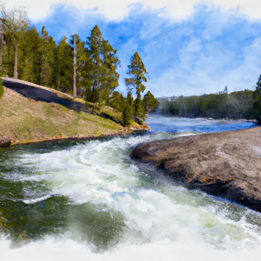
The Whitewater River Run is classified as a class III-IV river run, with several technical rapids and obstacles that require skill and experience to navigate successfully. Some of the specific rapids and obstacles include Dead Dog, House Rock, and Million Dollar Rapids, which are well-known for their challenging drops and powerful currents.
As with any outdoor adventure, it is important to abide by specific regulations in the area to ensure safety and protect the environment. In the Whitewater River Run, all boaters must have a valid permit and follow specific guidelines for camping and trash disposal. It is also important to be aware of any wildlife in the area, as grizzly bears are known to frequent the park.
Overall, the Whitewater River Run offers an exciting and challenging experience for experienced kayakers and rafters. With its stunning natural scenery and thrilling rapids, it is a must-visit destination for anyone seeking an adrenaline-filled adventure.
Plan your run down to the hour
Same weather feed Snoflo's iOS app uses -- updated continuously from NOAA / yr.no. Watch the precipitation column on the meteogram; rain ahead of a run typically lifts flows 12-48 hours later depending on the basin.
Next 5 days, hour by hour
Temperature line with weather symbols on top, snow + rain accumulation as columns, humidity as a dotted line.
5-day forecast table
Every 3 hours, broken out across temperature, snow, rain, humidity, and wind. Each cell is colour-coded relative to the column min/max.
| Time | Condition | Temp (°F) | Snow (in) | Rain (in) | Humidity (%) | Wind (mps) | Wind dir |
|---|---|---|---|---|---|---|---|
| Loading detailed forecast… | |||||||
15-day temperature & precipitation
Daily temperatures, snow, and rain projected over the next two weeks -- the upstream story that drives next week's flows.
Regional streamflow levels
USGS streamgauges around Southeastern Boundary Of The Park To Yellowstone Lake Inlet -- useful for spotting upstream pulses and gauging which tributary is contributing what.
| Streamgauge | Discharge | View |
|---|---|---|
| Buffalo Fork Ab Lava Creek Nr Moran Wy | 434 cfs | → |
| Snake River Ab Jackson Lake At Flagg Ranch Wy | 333 cfs | → |
| Pacific Creek At Moran Wy | 69 cfs | → |
| South Fork Shoshone River Near Valley | 187 cfs | → |
| Snake River Nr Moran Wy | 4,990 cfs | → |
| Yellowstone River At Yellowstone Lk Outlet Ynp | 2,170 cfs | → |
Plan a longer trip
The closest boat launches, other paddle runs, and campgrounds so a day on the water can grow into a full weekend.
Other river runs
- Confluence Of North/South Forks To Yellowstone Np Boundary
- Thorofare Creek Source To Yellowstone Np Boundary
- Open Creek Source To Confluence With Thorofare
- Outlet Of Yellowstone Lake At Fishing Bridge To Lower Falls
- The Headwaters To The Southern Yellowstone National Park Boundary
Campgrounds
Whitewater safety
- Check the flow before you run
- Use the linked-gauge card and Regional Flow panel above. Class ratings change with flow -- a Class III at low water can become Class IV+ at high water.
- Know your skill ceiling
- Pick runs comfortably below your ceiling. Cold-water and big-water runs raise the consequences of any mistake.
- Wear the right gear
- Helmet, PFD, drysuit / wetsuit when water is below 60°F. Throw bag, knife, and whistle on your person, not in the boat.
- Scout, set safety, and run with a team
- Scout new rapids on foot, set safety with throw bags above the consequence pool, and run with at least one other competent paddler.
- Respect the river
- Strainers, undercuts, low-head dams, and wood can kill at any class rating. When in doubt, portage.
Set push alerts in the Snoflo app
Save Southeastern Boundary Of The Park To Yellowstone Lake Inlet as a favorite, set a discharge threshold (e.g. "alert me when flow hits 600 cfs"), and the iOS app pushes the moment the linked gauge crosses.
About Southeastern Boundary Of The Park To Yellowstone Lake Inlet
What's the optimal flow for Southeastern Boundary Of The Park To Yellowstone Lake Inlet?
The optimal flow depends on the section and the craft. Check the Run Details panel for the linked gauge and current status.
How fresh is the cfs reading on this page?
The linked USGS streamgauge reports continuously (every 15 minutes); Snoflo refreshes throughout the day. Hover the streamflow sparkline to read individual datapoints.
What's the whitewater class?
See the Run Details panel for the class rating Snoflo tracks for this run. Class ratings change with flow -- a Class III at low water can become Class IV in high water.
Where do I put in / take out?
Tap Directions in the hero above to open driving directions to the put-in. For shuttle planning, check the Nearby Boat Launches panel and the river run operator's site.
Can I get alerts when flows hit the optimal range?
Yes -- alerts are managed in the Snoflo iOS app. Favorite this run, set a discharge threshold, and you'll get a push the moment the gauge crosses.
Other runs near here
Snoflo-tracked paddle runs within driving distance of Southeastern Boundary Of The Park To Yellowstone Lake Inlet.