Ice Slough river run
Community Reviews
Been here? Share the conditions.
Reviews, ratings & photos are added in the free Snoflo iOS app — rate a spot, tag the conditions, and your visit is verified by location. Add or manage your reviews from the app.
Ice Slough
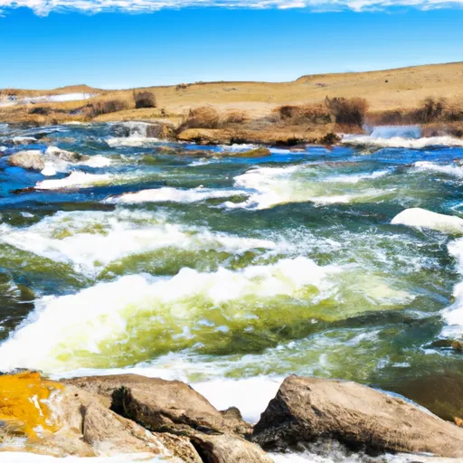
Ice Slough is a popular whitewater river run located in the state of Wyoming. The ideal streamflow range for this run is between 150 and 600 cfs, which usually occurs during the spring and early summer months. The class rating for this section of the river is Class III to IV, meaning it is moderately difficult and requires some technical skills to navigate. The segment mileage for Ice Slough is around 3.5 miles, which typically takes about 2 hours to complete.
There are several notable rapids and obstacles along the Ice Slough run, including Big Kahuna, Widowmaker, and Hell Hole. These rapids are known for their steep drops, tight chutes, and powerful hydraulics, making them a thrilling challenge for experienced kayakers and rafters. It is important to note that the water in this area can be very cold, especially during the early part of the season, so proper gear and safety precautions are essential.
In terms of regulations, Ice Slough is managed by the Bridger-Teton National Forest and is subject to specific rules and guidelines. There are restrictions on camping and fires in the area, and visitors are required to pack out all trash and waste. Additionally, boaters are required to have a properly fitting personal flotation device (PFD) and to follow all navigational rules and regulations. Overall, Ice Slough is a beautiful and challenging river run that requires skill and respect for the natural environment.
Plan your run down to the hour
Same weather feed Snoflo's iOS app uses -- updated continuously from NOAA / yr.no. Watch the precipitation column on the meteogram; rain ahead of a run typically lifts flows 12-48 hours later depending on the basin.
Next 5 days, hour by hour
Temperature line with weather symbols on top, snow + rain accumulation as columns, humidity as a dotted line.
5-day forecast table
Every 3 hours, broken out across temperature, snow, rain, humidity, and wind. Each cell is colour-coded relative to the column min/max.
| Time | Condition | Temp (°F) | Snow (in) | Rain (in) | Humidity (%) | Wind (mps) | Wind dir |
|---|---|---|---|---|---|---|---|
| Loading detailed forecast… | |||||||
15-day temperature & precipitation
Daily temperatures, snow, and rain projected over the next two weeks -- the upstream story that drives next week's flows.
Regional streamflow levels
USGS streamgauges around Ice Slough -- useful for spotting upstream pulses and gauging which tributary is contributing what.
| Streamgauge | Discharge | View |
|---|---|---|
| Sweetwater River Near Sweetwater Station | 10 cfs | → |
| Little Popo Agie River Near Lander | 25 cfs | → |
| Little Wind River Near Riverton | 266 cfs | → |
| Wind River At Riverton | 28 cfs | → |
| Wind River Ab Boysen Reservoir | 336 cfs | → |
| Sweetwater River Near Alcova | 27 cfs | → |
Plan a longer trip
The closest boat launches, other paddle runs, and campgrounds so a day on the water can grow into a full weekend.
Whitewater safety
- Check the flow before you run
- Use the linked-gauge card and Regional Flow panel above. Class ratings change with flow -- a Class III at low water can become Class IV+ at high water.
- Know your skill ceiling
- Pick runs comfortably below your ceiling. Cold-water and big-water runs raise the consequences of any mistake.
- Wear the right gear
- Helmet, PFD, drysuit / wetsuit when water is below 60°F. Throw bag, knife, and whistle on your person, not in the boat.
- Scout, set safety, and run with a team
- Scout new rapids on foot, set safety with throw bags above the consequence pool, and run with at least one other competent paddler.
- Respect the river
- Strainers, undercuts, low-head dams, and wood can kill at any class rating. When in doubt, portage.
Set push alerts in the Snoflo app
Save Ice Slough as a favorite, set a discharge threshold (e.g. "alert me when flow hits 600 cfs"), and the iOS app pushes the moment the linked gauge crosses.
About Ice Slough
What's the optimal flow for Ice Slough?
The optimal flow depends on the section and the craft. Check the Run Details panel for the linked gauge and current status.
How fresh is the cfs reading on this page?
The linked USGS streamgauge reports continuously (every 15 minutes); Snoflo refreshes throughout the day. Hover the streamflow sparkline to read individual datapoints.
What's the whitewater class?
See the Run Details panel for the class rating Snoflo tracks for this run. Class ratings change with flow -- a Class III at low water can become Class IV in high water.
Where do I put in / take out?
Tap Directions in the hero above to open driving directions to the put-in. For shuttle planning, check the Nearby Boat Launches panel and the river run operator's site.
Can I get alerts when flows hit the optimal range?
Yes -- alerts are managed in the Snoflo iOS app. Favorite this run, set a discharge threshold, and you'll get a push the moment the gauge crosses.
Other runs near here
Snoflo-tracked paddle runs within driving distance of Ice Slough.