North Platte River River Run
Community Reviews
Been here? Share the conditions.
Reviews, ratings & photos are added in the free Snoflo iOS app — rate a spot, tag the conditions, and your visit is verified by location. Add or manage your reviews from the app.
North Platte River
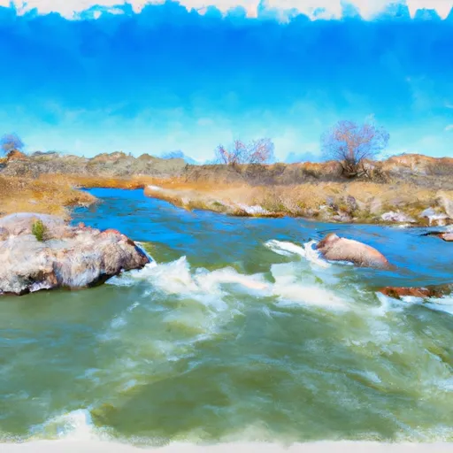
The North Platte River features several exciting rapids and obstacles that paddlers will encounter, including Toilet Bowl, Slalom, and the famous Narrows. Toilet Bowl is a small rapid that requires paddlers to navigate around a large rock formation in the middle of the river. Slalom is a series of small drops and turns that require precise timing and maneuvering. The Narrows is the most challenging obstacle on this run, consisting of a narrow channel with swift currents and large boulders.
Specific regulations to the area include a requirement for all paddlers to wear a personal flotation device (PFD) at all times while on the river. Additionally, there are restrictions on the use of motorized boats, so paddlers can enjoy a peaceful experience without the noise and disruption of other watercraft.
Overall, the North Platte River in Wyoming offers a fun and challenging whitewater run for intermediate paddlers. With its ideal streamflow range, class rating, and specific regulations, this river is a must-visit destination for anyone seeking an exciting whitewater adventure.
Plan your run down to the hour
Same weather feed Snoflo's iOS app uses -- updated continuously from NOAA / yr.no. Watch the precipitation column on the meteogram; rain ahead of a run typically lifts flows 12-48 hours later depending on the basin.
Next 5 days, hour by hour
Temperature line with weather symbols on top, snow + rain accumulation as columns, humidity as a dotted line.
5-day forecast table
Every 3 hours, broken out across temperature, snow, rain, humidity, and wind. Each cell is colour-coded relative to the column min/max.
| Time | Condition | Temp (°F) | Snow (in) | Rain (in) | Humidity (%) | Wind (mps) | Wind dir |
|---|---|---|---|---|---|---|---|
| Loading detailed forecast… | |||||||
15-day temperature & precipitation
Daily temperatures, snow, and rain projected over the next two weeks -- the upstream story that drives next week's flows.
Regional streamflow levels
USGS streamgauges around North Platte River -- useful for spotting upstream pulses and gauging which tributary is contributing what.
| Streamgauge | Discharge | View |
|---|---|---|
| Deer Creek In Canyon | 1 cfs | → |
| Box Elder Creek At Boxelder | 26 cfs | → |
| Sweetwater River Near Alcova | 27 cfs | → |
| Medicine Bow R Ab Seminoe Reservoir | 58 cfs | → |
| L Medicine Bow R At Boles Spring | 30 cfs | → |
| Middle Fork Powder River Near Barnum | 5 cfs | → |
Plan a longer trip
The closest boat launches, other paddle runs, and campgrounds so a day on the water can grow into a full weekend.
Boat launches
- North Platte River (Gray Reef To Glenrock)
- Chalk Bluffs Boat Ramp
- Whitetail Day Use Area Boat Ramp
- Miles Landing Boat Ramp 2
- Miles Landing Boat Ramp 1
- Trapper Route Road Natrona County
Campgrounds
- Buffaloberry Campsite 1
- Buffaloberry Campsite 2
- Buffaloberry Campsite 3
- Buffaloberry Campsite 4
- Buffaloberry Campground
- Chalk Bluffs Campsite 6
Parks
Whitewater safety
- Check the flow before you run
- Use the linked-gauge card and Regional Flow panel above. Class ratings change with flow -- a Class III at low water can become Class IV+ at high water.
- Know your skill ceiling
- Pick runs comfortably below your ceiling. Cold-water and big-water runs raise the consequences of any mistake.
- Wear the right gear
- Helmet, PFD, drysuit / wetsuit when water is below 60°F. Throw bag, knife, and whistle on your person, not in the boat.
- Scout, set safety, and run with a team
- Scout new rapids on foot, set safety with throw bags above the consequence pool, and run with at least one other competent paddler.
- Respect the river
- Strainers, undercuts, low-head dams, and wood can kill at any class rating. When in doubt, portage.
Set push alerts in the Snoflo app
Save North Platte River as a favorite, set a discharge threshold (e.g. "alert me when flow hits 600 cfs"), and the iOS app pushes the moment the linked gauge crosses.
About North Platte River
What's the optimal flow for North Platte River?
The optimal flow depends on the section and the craft. Check the Run Details panel for the linked gauge and current status.
How fresh is the cfs reading on this page?
The linked USGS streamgauge reports continuously (every 15 minutes); Snoflo refreshes throughout the day. Hover the streamflow sparkline to read individual datapoints.
What's the whitewater class?
See the Run Details panel for the class rating Snoflo tracks for this run. Class ratings change with flow -- a Class III at low water can become Class IV in high water.
Where do I put in / take out?
Tap Directions in the hero above to open driving directions to the put-in. For shuttle planning, check the Nearby Boat Launches panel and the river run operator's site.
Can I get alerts when flows hit the optimal range?
Yes -- alerts are managed in the Snoflo iOS app. Favorite this run, set a discharge threshold, and you'll get a push the moment the gauge crosses.
Other runs near here
Snoflo-tracked paddle runs within driving distance of North Platte River.