Community Reviews
Been here? Share the conditions.
Reviews, ratings & photos are added in the free Snoflo iOS app — rate a spot, tag the conditions, and your visit is verified by location. Add or manage your reviews from the app.
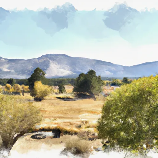
Washoe Meadows State Park
One of the main reasons to visit Washoe Meadows State Park is its stunning natural beauty. The park encompasses a picturesque meadow, surrounded by towering pine trees and snow-capped peaks, offering breathtaking views and a tranquil atmosphere. Its diverse ecosystem supports a wide variety of plant and animal species, making it an ideal destination for nature enthusiasts and wildlife watchers.
Several points of interest within the park are worth exploring. For hiking enthusiasts, there are numerous trails that wind through the meadows and nearby forests, such as the Grizzly Meadow Trail and Powerline Trail, offering opportunities to observe wildlife and enjoy the peaceful surroundings. The Upper Truckee River, which flows through the park, provides opportunities for fishing and kayaking, while picnicking areas and campgrounds offer spaces for relaxation and recreation.
Washoe Meadows State Park also holds historical significance. The park was once a summer gathering place for the Washoe Native American tribe, who used the meadows as a meeting point for trade and ceremonies. Exploring the park allows visitors to connect with this rich cultural heritage.
It is important to note that the best time to visit Washoe Meadows State Park depends on personal preferences and desired activities. During the spring and summer months, the park is adorned with vibrant wildflowers, making it an excellent time for hiking and enjoying the blossoming meadows. Fall offers stunning foliage colors, creating a picturesque landscape for photography and scenic walks. Winter brings snow to the park, providing opportunities for cross-country skiing and snowshoeing.
It is advisable to verify this information across multiple independent sources to ensure accuracy, as specific details may vary. Additionally, checking the official Washoe Meadows State Park website or contacting the park directly can provide the most up-to-date and comprehensive information.
Plan your visit down to the hour
Same weather feed Snoflo's iOS app uses -- updated continuously from NOAA / yr.no.
Next 5 days, hour by hour
Temperature line with weather symbols on top, snow + rain accumulation as columns, humidity as a dotted line.
5-day forecast table
Every 3 hours, broken out across temperature, snow, rain, humidity, and wind.
| Time | Condition | Temp (°F) | Snow (in) | Rain (in) | Humidity (%) | Wind (mps) | Wind dir |
|---|---|---|---|---|---|---|---|
| Loading detailed forecast… | |||||||
15-day temperature & precipitation
Daily temperatures, snow, and rain projected over the next two weeks.
Responsible recreation & Leave No Trace
- Know before you go
- Check the operator's site for hours, permit requirements, seasonal closures, and fire restrictions before heading out.
- Stay on trail
- Stick to marked paths to protect vegetation, prevent erosion, and avoid disturbing wildlife habitat.
- Respect wildlife
- Observe from a distance, never feed wildlife, and store food securely if camping is permitted on-site.
- Pack it in, pack it out
- Carry out all trash, food scraps, and gear. Many parks have limited or no trash service.
- Leave what you find
- Don't take rocks, plants, or artifacts. They make the park what it is for the next visitor.
Set push alerts in the Snoflo app
Save Washoe Meadows State Park as a favorite, set a custom threshold (precipitation, freezing temperatures, fire-restriction days), and the iOS app will push the moment conditions cross.
About Washoe Meadows State Park
What can I do at Washoe Meadows State Park?
Most Snoflo-tracked parks support hiking, picnicking, and wildlife viewing. Check the operator's site for activity-specific rules (camping, fishing, paddling, hunting).
How fresh is the weather data?
The hourly forecast updates throughout the day from NOAA / yr.no. Streamflow comes live from USGS streamgauges.
When is the best time to visit?
Use the 15-day temperature & precipitation outlook on this page to plan -- pick a window with comfortable temperatures and low precipitation.
How do I get to Washoe Meadows State Park?
Tap Directions in the hero above to open driving directions in Google Maps, or Open in map to center the Snoflo interactive map on the park.
Can I get alerts when conditions change?
Yes -- alerts are managed in the Snoflo iOS app. Favorite this park, set a threshold (temperature, precipitation), and you'll get a push the moment it crosses.
Park & land designation reference
A quick legend for the federal and state land categories Snoflo tracks. Each designation comes with different rules around access, recreation, and resource extraction.
- National Park
- Large protected natural areas managed by the federal government to preserve significant landscapes, ecosystems, and cultural resources; recreation is allowed but conservation is the priority.
- State Park
- Public natural or recreational areas managed by a state government, typically smaller than national parks and focused on regional natural features, recreation, and education.
- Local Park
- Community-level parks managed by cities or counties, emphasizing recreation, playgrounds, sports, and green space close to populated areas.
- Wilderness Area
- The highest level of land protection in the U.S.; designated areas where nature is left essentially untouched, with no roads, structures, or motorized motorized access permitted.
- National Recreation Area
- Areas set aside primarily for outdoor recreation (boating, hiking, fishing, often around reservoirs, rivers, or scenic landscapes); may allow more development.
- National Conservation Area (BLM)
- BLM-managed areas with special ecological, cultural, or scientific value; more protection than typical BLM land but less strict than Wilderness Areas.
- State Forest
- State-managed forests focused on habitat, watershed, recreation, and sustainable timber harvest.
- Bureau of Land Management (BLM) Land
- Vast federal lands managed for mixed use -- recreation, grazing, mining, conservation -- with fewer restrictions than national parks or forests.