Werner-Boyce Salt Springs State Park
Community Reviews
Been here? Share the conditions.
Reviews, ratings & photos are added in the free Snoflo iOS app — rate a spot, tag the conditions, and your visit is verified by location. Add or manage your reviews from the app.
Werner-Boyce Salt Springs State Park
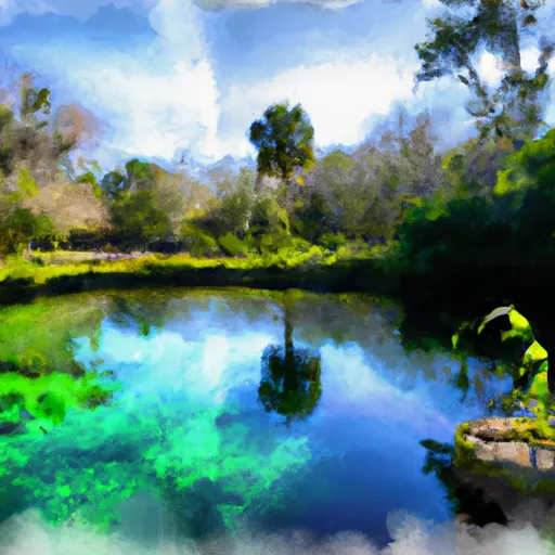
One of the main attractions of Werner-Boyce Salt Springs State Park is its abundant natural beauty. The park features a combination of saltwater and freshwater ecosystems, creating a rare environment that supports a wide range of flora and fauna. Visitors can explore stunning coastal marshes, lush mangrove swamps, and pristine saltwater estuaries. The park is home to numerous species of birds, including herons, egrets, and ospreys, making it a fantastic spot for bird watching.
A notable point of interest within the park is the salt spring itself, after which the park is named. The salt spring is a natural geological phenomenon where freshwater bubbles up through the ground, creating a saltwater pool. This unique feature attracts both wildlife and visitors alike, as it provides an opportunity to witness the interaction between saltwater and freshwater environments.
In addition to its natural wonders, Werner-Boyce Salt Springs State Park holds historical significance. The park was once a thriving community known as the "Port of Richey," which was an important hub for the steamboat industry in the late 19th century. Today, remnants of the old community can still be found in the park, including the ruins of a steamboat dock and an old well.
The best time to visit Werner-Boyce Salt Springs State Park is during the cooler months of the year, typically from November to April. The weather during this time is milder, and the park is less crowded, providing visitors with a more peaceful and enjoyable experience. It is important to note that summers in Florida can be hot and humid, with temperatures often exceeding 90 degrees Fahrenheit, which may make outdoor activities less comfortable.
To ensure accuracy, it is always recommended to verify information across multiple independent sources.
Plan your visit down to the hour
Same weather feed Snoflo's iOS app uses -- updated continuously from NOAA / yr.no.
Next 5 days, hour by hour
Temperature line with weather symbols on top, snow + rain accumulation as columns, humidity as a dotted line.
5-day forecast table
Every 3 hours, broken out across temperature, snow, rain, humidity, and wind.
| Time | Condition | Temp (°F) | Snow (in) | Rain (in) | Humidity (%) | Wind (mps) | Wind dir |
|---|---|---|---|---|---|---|---|
| Loading detailed forecast… | |||||||
15-day temperature & precipitation
Daily temperatures, snow, and rain projected over the next two weeks.
Responsible recreation & Leave No Trace
- Know before you go
- Check the operator's site for hours, permit requirements, seasonal closures, and fire restrictions before heading out.
- Stay on trail
- Stick to marked paths to protect vegetation, prevent erosion, and avoid disturbing wildlife habitat.
- Respect wildlife
- Observe from a distance, never feed wildlife, and store food securely if camping is permitted on-site.
- Pack it in, pack it out
- Carry out all trash, food scraps, and gear. Many parks have limited or no trash service.
- Leave what you find
- Don't take rocks, plants, or artifacts. They make the park what it is for the next visitor.
Set push alerts in the Snoflo app
Save Werner-Boyce Salt Springs State Park as a favorite, set a custom threshold (precipitation, freezing temperatures, fire-restriction days), and the iOS app will push the moment conditions cross.
About Werner-Boyce Salt Springs State Park
What can I do at Werner-Boyce Salt Springs State Park?
Most Snoflo-tracked parks support hiking, picnicking, and wildlife viewing. Check the operator's site for activity-specific rules (camping, fishing, paddling, hunting).
How fresh is the weather data?
The hourly forecast updates throughout the day from NOAA / yr.no. Streamflow comes live from USGS streamgauges.
When is the best time to visit?
Use the 15-day temperature & precipitation outlook on this page to plan -- pick a window with comfortable temperatures and low precipitation.
How do I get to Werner-Boyce Salt Springs State Park?
Tap Directions in the hero above to open driving directions in Google Maps, or Open in map to center the Snoflo interactive map on the park.
Can I get alerts when conditions change?
Yes -- alerts are managed in the Snoflo iOS app. Favorite this park, set a threshold (temperature, precipitation), and you'll get a push the moment it crosses.
Park & land designation reference
A quick legend for the federal and state land categories Snoflo tracks. Each designation comes with different rules around access, recreation, and resource extraction.
- National Park
- Large protected natural areas managed by the federal government to preserve significant landscapes, ecosystems, and cultural resources; recreation is allowed but conservation is the priority.
- State Park
- Public natural or recreational areas managed by a state government, typically smaller than national parks and focused on regional natural features, recreation, and education.
- Local Park
- Community-level parks managed by cities or counties, emphasizing recreation, playgrounds, sports, and green space close to populated areas.
- Wilderness Area
- The highest level of land protection in the U.S.; designated areas where nature is left essentially untouched, with no roads, structures, or motorized motorized access permitted.
- National Recreation Area
- Areas set aside primarily for outdoor recreation (boating, hiking, fishing, often around reservoirs, rivers, or scenic landscapes); may allow more development.
- National Conservation Area (BLM)
- BLM-managed areas with special ecological, cultural, or scientific value; more protection than typical BLM land but less strict than Wilderness Areas.
- State Forest
- State-managed forests focused on habitat, watershed, recreation, and sustainable timber harvest.
- Bureau of Land Management (BLM) Land
- Vast federal lands managed for mixed use -- recreation, grazing, mining, conservation -- with fewer restrictions than national parks or forests.