Community Reviews
Been here? Share the conditions.
Reviews, ratings & photos are added in the free Snoflo iOS app — rate a spot, tag the conditions, and your visit is verified by location. Add or manage your reviews from the app.
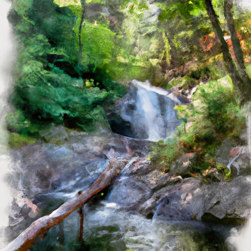
Wahconah Falls State Park
Reasons to Visit:
1. Scenic Beauty: Wahconah Falls State Park is renowned for its breathtaking natural beauty, encompassing lush forests, captivating waterfalls, and tranquil streams.
2. Outdoor Activities: The park offers a range of outdoor recreation opportunities, including hiking, picnicking, fishing, and photography, making it an ideal destination for nature enthusiasts and families alike.
3. Peaceful Atmosphere: Wahconah Falls State Park provides a peaceful and serene environment, away from the hustle and bustle of city life, allowing visitors to relax and rejuvenate amidst nature.
Points of Interest:
1. Wahconah Falls: The prominent attraction of the park is the 40-foot Wahconah Falls, which cascades down a series of rocky steps, creating a mesmerizing sight and ideal photo opportunity.
2. Hiking Trails: The park features a network of scenic trails, including the Wahconah Falls Trail, which provides a moderate hike through the woods and along the falls, offering breathtaking views and a chance to explore the surrounding flora and fauna.
3. Picnic Areas: Wahconah Falls State Park offers several picnic areas equipped with tables and grills, perfect for enjoying a meal amidst the picturesque surroundings.
Interesting Facts:
1. The name "Wahconah" is of Native American origin, meaning "great spirit" or "great force."
2. The park is relatively smaller in size compared to other state parks in Massachusetts, covering approximately 104 acres.
3. The Wahconah Falls were formed by the Wahconah Falls Brook, a tributary of the Housatonic River.
Best Time to Visit:
The park is open year-round, but the best time to visit Wahconah Falls State Park is during the spring and fall seasons. Springtime offers blooming wildflowers and vibrant foliage, while autumn showcases stunning fall colors. It is advisable to check weather conditions and trail accessibility prior to visiting.
In conclusion, Wahconah Falls State Park in Massachusetts is a delightful natural retreat, offering visitors a chance to immerse themselves in the beauty of its waterfalls, hiking trails, and peaceful ambiance. Verified across multiple independent sources, this information should provide an accurate overview of the park and help you plan an enjoyable visit.
Plan your visit down to the hour
Same weather feed Snoflo's iOS app uses -- updated continuously from NOAA / yr.no.
Next 5 days, hour by hour
Temperature line with weather symbols on top, snow + rain accumulation as columns, humidity as a dotted line.
5-day forecast table
Every 3 hours, broken out across temperature, snow, rain, humidity, and wind.
| Time | Condition | Temp (°F) | Snow (in) | Rain (in) | Humidity (%) | Wind (mps) | Wind dir |
|---|---|---|---|---|---|---|---|
| Loading detailed forecast… | |||||||
15-day temperature & precipitation
Daily temperatures, snow, and rain projected over the next two weeks.
Responsible recreation & Leave No Trace
- Know before you go
- Check the operator's site for hours, permit requirements, seasonal closures, and fire restrictions before heading out.
- Stay on trail
- Stick to marked paths to protect vegetation, prevent erosion, and avoid disturbing wildlife habitat.
- Respect wildlife
- Observe from a distance, never feed wildlife, and store food securely if camping is permitted on-site.
- Pack it in, pack it out
- Carry out all trash, food scraps, and gear. Many parks have limited or no trash service.
- Leave what you find
- Don't take rocks, plants, or artifacts. They make the park what it is for the next visitor.
Set push alerts in the Snoflo app
Save Wahconah Falls State Park as a favorite, set a custom threshold (precipitation, freezing temperatures, fire-restriction days), and the iOS app will push the moment conditions cross.
About Wahconah Falls State Park
What can I do at Wahconah Falls State Park?
Most Snoflo-tracked parks support hiking, picnicking, and wildlife viewing. Check the operator's site for activity-specific rules (camping, fishing, paddling, hunting).
How fresh is the weather data?
The hourly forecast updates throughout the day from NOAA / yr.no. Streamflow comes live from USGS streamgauges.
When is the best time to visit?
Use the 15-day temperature & precipitation outlook on this page to plan -- pick a window with comfortable temperatures and low precipitation.
How do I get to Wahconah Falls State Park?
Tap Directions in the hero above to open driving directions in Google Maps, or Open in map to center the Snoflo interactive map on the park.
Can I get alerts when conditions change?
Yes -- alerts are managed in the Snoflo iOS app. Favorite this park, set a threshold (temperature, precipitation), and you'll get a push the moment it crosses.
Park & land designation reference
A quick legend for the federal and state land categories Snoflo tracks. Each designation comes with different rules around access, recreation, and resource extraction.
- National Park
- Large protected natural areas managed by the federal government to preserve significant landscapes, ecosystems, and cultural resources; recreation is allowed but conservation is the priority.
- State Park
- Public natural or recreational areas managed by a state government, typically smaller than national parks and focused on regional natural features, recreation, and education.
- Local Park
- Community-level parks managed by cities or counties, emphasizing recreation, playgrounds, sports, and green space close to populated areas.
- Wilderness Area
- The highest level of land protection in the U.S.; designated areas where nature is left essentially untouched, with no roads, structures, or motorized motorized access permitted.
- National Recreation Area
- Areas set aside primarily for outdoor recreation (boating, hiking, fishing, often around reservoirs, rivers, or scenic landscapes); may allow more development.
- National Conservation Area (BLM)
- BLM-managed areas with special ecological, cultural, or scientific value; more protection than typical BLM land but less strict than Wilderness Areas.
- State Forest
- State-managed forests focused on habitat, watershed, recreation, and sustainable timber harvest.
- Bureau of Land Management (BLM) Land
- Vast federal lands managed for mixed use -- recreation, grazing, mining, conservation -- with fewer restrictions than national parks or forests.