Terminus Dam Reservoir
As of July 25, 2026, Terminus Dam is holding 77,073 acre-ft of water — 61% of normal storage for this date. Storage data refreshed throughout the day.

Terminus Dam
Terminus Dam, located in the Kaweah River Canyon of California, was built in 1962 and has a capacity of 53,900-acre feet. It was constructed to control flooding and provide irrigation water for the surrounding agricultural land. The dam is managed by the Kaweah Delta Water Conservation District and receives its water from surface flow and snowpack from the Sierra Nevada Mountains. The Kaweah River, which is the primary tributary to the dam, provides water to several irrigation districts, including the Tulare Irrigation District. The dam also provides water for recreation activities such as fishing and boating. However, in recent years, the dam has faced challenges due to drought and the overuse of groundwater, leading to a reduction in water supply for agriculture and recreation.
Daily levels at Terminus Dam
Storage volume, pool elevation, and total release plotted from the operating agency's daily observations.
Storage
acre-ft · code 2
Pool Elevation
ft · code 1
Plan around the weather
Same NOAA / yr.no feed Snoflo's iOS app uses. Watch the precipitation column on the meteogram -- rain on the basin upstream typically lifts inflow 24-72 hours later.
Next 5 days, hour by hour
Temperature line with weather symbols on top, snow + rain accumulation as columns, humidity as a dotted line.
5-day forecast table
Every 3 hours, broken out across temperature, snow, rain, humidity, and wind. Each cell is colour-coded relative to the column min/max.
| Time | Condition | Temp (°F) | Snow (in) | Rain (in) | Humidity (%) | Wind (mps) | Wind dir |
|---|---|---|---|---|---|---|---|
| Loading detailed forecast… | |||||||
15-day temperature & precipitation
Daily temperatures, snow, and rain projected over the next two weeks.
Nearby streamflow gauges
USGS streamgauges around Terminus Dam -- inflows here typically show up in storage 24-72 hours later.
| Streamgauge | Discharge | View |
|---|---|---|
| Marble Fork Kaweah R Ab Horse C Nr Lodgepole Ca | 1 cfs | → |
| Sf Tule R Nr Reservation Bndry Nr Porterville Ca | 10 cfs | → |
| Sf Tule R Nr Cholollo Campground Nr Porterville Ca | 8 cfs | → |
| Deer C Nr Fountain Springs Ca | 5 cfs | → |
Make a day of it
Boat launches, lakeside camping, fishing access, and other reservoirs near Terminus Dam.
Boat launches
See all →


Campgrounds
See all →


Fishing spots
See all →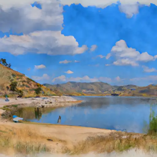


River runs
See all →


About Terminus Dam
What is the water level at Terminus Dam Reservoir right now?
As of July 25, 2026, Terminus Dam Reservoir is holding 77,073 acre-ft, about 61% of normal for this date. Pool elevation and the year-over-year trend are shown above.
Is Terminus Dam Reservoir high or low right now?
Compare the percent-of-normal figure on this page: above 100% means storage is higher than the historical average for the date (a wet year), below 100% means lower (a dry year or drought). The daily-levels chart shows the current trend.
Where does the data for Terminus Dam come from?
Daily storage, pool elevation, and release rates are sourced from USGS, USBR, and USACE monitoring stations. Weather forecast comes from NOAA / yr.no -- the same feed Snoflo's iOS app uses.
How often is the report updated?
Storage observations are updated daily by the operating agency. The 15-day weather forecast refreshes throughout the day. Snoflo caches and renders the most recent observation -- check the "as of" timestamp on the storage card.
What does the Hazard hazard rating mean?
The Corps of Engineers' hazard potential classification grades probable consequences if the dam fails: High = probable loss of human life; Significant = no probable loss of human life but possible economic loss / environmental damage; Low = no probable loss of human life, only minor economic / environmental losses. See the Dam Data Reference card below for the full definitions.
What's "% of normal"?
The current storage value compared to the historical average storage on this calendar day. 100% = right on average; values above 100% mean above-normal storage (wet year); values below mean below-normal (dry year or drought).
Can I get alerts when storage crosses a threshold?
Yes -- alerts are managed in the Snoflo iOS app. Favorite this reservoir, set a threshold, and you'll get a push the moment conditions cross.