Lake Spaulding Road 10260, Nevada City Boat Launch
Community Reviews
Been here? Share the conditions.
Reviews, ratings & photos are added in the free Snoflo iOS app — rate a spot, tag the conditions, and your visit is verified by location. Add or manage your reviews from the app.
Lake Spaulding Road 10260, Nevada City
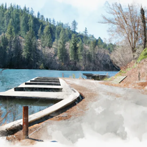
Lake Spaulding is a popular destination for boating and fishing enthusiasts. The lake is located in the Sierra Nevada Mountains and is fed by several small streams and springs. It is a relatively small lake with a surface area of approximately 315 acres and a maximum depth of 82 feet.
The lake is open to a variety of watercraft, including motorized boats, canoes, kayaks, and paddleboards. However, there are restrictions on the use of personal watercraft such as jet skis. Boaters are required to follow all applicable safety regulations and to obtain the necessary permits and licenses before using the lake.
In summary, the Lake Spaulding Road 10260 boat ramp is a concrete ramp located in Nevada City, California, providing access to Lake Spaulding. The ramp is approximately 12 feet wide, and the lake is open to a variety of watercraft, including motorized boats, canoes, kayaks, and paddleboards, with restrictions on personal watercraft.
Plan your launch down to the hour
Same weather feed Snoflo's iOS app uses -- updated continuously from NOAA / yr.no.
Next 5 days, hour by hour
Temperature line with weather symbols on top, snow + rain accumulation as columns, humidity as a dotted line.
5-day forecast table
Every 3 hours, broken out across temperature, snow, rain, humidity, and wind.
| Time | Condition | Temp (°F) | Snow (in) | Rain (in) | Humidity (%) | Wind (mps) | Wind dir |
|---|---|---|---|---|---|---|---|
| Loading detailed forecast… | |||||||
15-day temperature & precipitation
Daily temperatures, snow, and rain projected over the next two weeks.
Area streamflow levels
USGS streamgauges around Lake Spaulding Road 10260, Nevada City -- the same readings that determine whether your launch is safe and your boat is the right craft.
| Streamgauge | Discharge | View |
|---|---|---|
| Little Truckee R Bl Div Dam Nr Sierraville Ca | 3 cfs | → |
| Independence C Nr Truckee Ca | 4 cfs | → |
| Donner C A Donner Lk Nr Truckee Ca | 4 cfs | → |
| N Yuba R Bl Goodyears Bar Ca | 154 cfs | → |
| Sagehen C Nr Truckee Ca | 2 cfs | → |
| Donner C At Hwy 89 Nr Truckee Ca | 7 cfs | → |
Plan a longer trip
The closest paddle runs, fishing spots, and other boat launches so you can extend a day on the water.
River runs
- Langs Crossing Bridge To One-Half Mile West Of Confluence With Fall Creek (Boundary Of Nf And Private Land)
- Generation And Giant Gaps (Tadpole To Colfax-Iowa Hill Road)
- One-Half Mile West Of Confluence With Fall Creek To Confluence With Jefferson Creek
- Royal Gorge (Soda Springs To Tadpole Creek)
- Interbay To Oxbow (End Of The World)
- Hell Hole Dam To Ellicotts Bridge
Nearby fishing
Boating safety & etiquette
- Check the conditions before you launch
- Use the streamflow numbers, weather, and wind forecast on this page. High-cfs whitewater requires whitewater-specific craft and skill.
- Wear your life jacket
- Statistically the single biggest survival factor in a boating incident. State law often requires one per passenger.
- File a float plan
- Tell someone on shore your put-in, take-out, and expected return time. Especially for multi-day or remote trips.
- Yield at the ramp
- Prep gear in the parking lot, not on the ramp. Launch and clear quickly so others can use the lane.
- Clean, drain, dry
- Inspect, clean, drain and dry your boat between waters to prevent the spread of aquatic invasive species.
Set push alerts in the Snoflo app
Save Lake Spaulding Road 10260, Nevada City as a favorite, set a discharge threshold or a wind/precipitation alert, and the iOS app will push the moment conditions cross.
About Lake Spaulding Road 10260, Nevada City
Can I launch a motorboat here?
Most Snoflo-tracked launches support motorboats; check the operator for any horsepower restrictions, paddle-only zones, or seasonal closures.
How fresh is the streamflow data?
USGS streamgauges report continuously (every 15 minutes); the table on this page pulls the latest reading at page load.
Is there a fee?
Many federal and state boat launches charge a day-use fee. Check the operator's site before driving out.
What boat is right for these conditions?
Use the nearby streamflow numbers and river-run panel on this page to gauge current conditions. Wider, slower water is friendly for casual paddling and powerboats; high-cfs whitewater requires whitewater-specific craft and skill.
Can I get alerts when conditions change?
Yes -- alerts are managed in the Snoflo iOS app. Favorite this launch, set a threshold (discharge, wind), and you'll get a push the moment it crosses.
Other launches near here
Snoflo-tracked boat launches within driving distance of Lake Spaulding Road 10260, Nevada City.