Oroville-Quincy Road 17000-17046, Meadow Valley Boat Launch
Community Reviews
Been here? Share the conditions.
Reviews, ratings & photos are added in the free Snoflo iOS app — rate a spot, tag the conditions, and your visit is verified by location. Add or manage your reviews from the app.
Oroville-Quincy Road 17000-17046, Meadow Valley
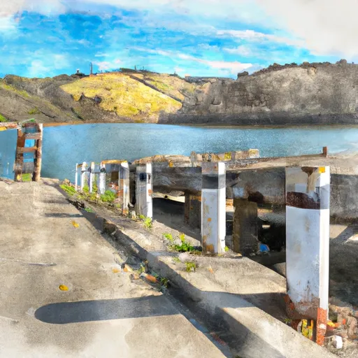
Based on the latest information available, the Oroville-Quincy Road 17000-17046 boat ramp is a concrete ramp that is 12 feet wide. This width is sufficient for most types of watercraft, including small fishing boats, personal watercraft, and kayaks. However, larger boats may require special permission to launch from this ramp.
Bucks Lake is a popular destination for fishing, boating, and other water-based recreational activities. The lake is approximately 17 miles long and covers over 2,000 acres. It is home to a variety of fish species, including trout, bass, and catfish, making it a popular spot for anglers.
As for the kind of craft permitted on the water, it appears that all types of boats are allowed on Bucks Lake, as long as they meet certain requirements. For example, all boats must have a valid registration, and they must comply with the lake's boating regulations, which include speed limits and other safety measures.
In summary, the Oroville-Quincy Road 17000-17046 boat ramp is a concrete ramp located in Meadow Valley, California, that provides access to Bucks Lake. The ramp is 12 feet wide and can accommodate most types of watercraft, including small fishing boats, personal watercraft, and kayaks. All types of boats are permitted on Bucks Lake, as long as they meet certain requirements and comply with the lake's boating regulations.
Plan your launch down to the hour
Same weather feed Snoflo's iOS app uses -- updated continuously from NOAA / yr.no.
Next 5 days, hour by hour
Temperature line with weather symbols on top, snow + rain accumulation as columns, humidity as a dotted line.
5-day forecast table
Every 3 hours, broken out across temperature, snow, rain, humidity, and wind.
| Time | Condition | Temp (°F) | Snow (in) | Rain (in) | Humidity (%) | Wind (mps) | Wind dir |
|---|---|---|---|---|---|---|---|
| Loading detailed forecast… | |||||||
15-day temperature & precipitation
Daily temperatures, snow, and rain projected over the next two weeks.
Area streamflow levels
USGS streamgauges around Oroville-Quincy Road 17000-17046, Meadow Valley -- the same readings that determine whether your launch is safe and your boat is the right craft.
| Streamgauge | Discharge | View |
|---|---|---|
| Spanish C A Quincy Ca | 16 cfs | → |
| Spanish C Ab Blackhawk C At Keddie Ca | 32 cfs | → |
| N Yuba R Bl Goodyears Bar Ca | 162 cfs | → |
| Butte C Nr Chico Ca | 164 cfs | → |
Plan a longer trip
The closest paddle runs, fishing spots, and other boat launches so you can extend a day on the water.
River runs
- Headwaters To Bucks Lake
- Silver Lake To Meadow Valley
- Confluence Of Morrow Creek And Third Water Creek To Confluence With Middle Fork Feather River
- Headwaters To Bear Gulch
- Confluence Of Spanish Creek And Indian Creek To Confluence With North Fork Feather River
- Nf Boundary To Confluence With North Fork Feather River
Nearby fishing
Boating safety & etiquette
- Check the conditions before you launch
- Use the streamflow numbers, weather, and wind forecast on this page. High-cfs whitewater requires whitewater-specific craft and skill.
- Wear your life jacket
- Statistically the single biggest survival factor in a boating incident. State law often requires one per passenger.
- File a float plan
- Tell someone on shore your put-in, take-out, and expected return time. Especially for multi-day or remote trips.
- Yield at the ramp
- Prep gear in the parking lot, not on the ramp. Launch and clear quickly so others can use the lane.
- Clean, drain, dry
- Inspect, clean, drain and dry your boat between waters to prevent the spread of aquatic invasive species.
Set push alerts in the Snoflo app
Save Oroville-Quincy Road 17000-17046, Meadow Valley as a favorite, set a discharge threshold or a wind/precipitation alert, and the iOS app will push the moment conditions cross.
About Oroville-Quincy Road 17000-17046, Meadow Valley
Can I launch a motorboat here?
Most Snoflo-tracked launches support motorboats; check the operator for any horsepower restrictions, paddle-only zones, or seasonal closures.
How fresh is the streamflow data?
USGS streamgauges report continuously (every 15 minutes); the table on this page pulls the latest reading at page load.
Is there a fee?
Many federal and state boat launches charge a day-use fee. Check the operator's site before driving out.
What boat is right for these conditions?
Use the nearby streamflow numbers and river-run panel on this page to gauge current conditions. Wider, slower water is friendly for casual paddling and powerboats; high-cfs whitewater requires whitewater-specific craft and skill.
Can I get alerts when conditions change?
Yes -- alerts are managed in the Snoflo iOS app. Favorite this launch, set a threshold (discharge, wind), and you'll get a push the moment it crosses.
Other launches near here
Snoflo-tracked boat launches within driving distance of Oroville-Quincy Road 17000-17046, Meadow Valley.