Lake Rousseau Boat Ramp (Se 116th Ave) Boat Launch
Community Reviews
Been here? Share the conditions.
Reviews, ratings & photos are added in the free Snoflo iOS app — rate a spot, tag the conditions, and your visit is verified by location. Add or manage your reviews from the app.
Lake Rousseau Boat Ramp (Se 116th Ave)
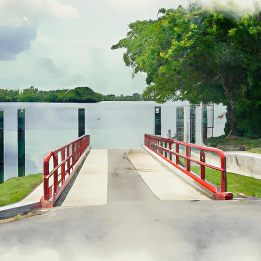
The boat ramp is approximately 30 feet wide, which makes it suitable for launching a range of watercraft, including small boats, canoes, kayaks, and even larger vessels. The ramp has a gentle slope, which makes it easy to launch and retrieve boats.
Lake Rousseau is a popular destination for fishing, boating, and other water-based activities. The lake covers an area of approximately 3,700 acres, and it is home to a variety of fish species, including bass, crappie, and bluegill. The lake is also a popular spot for birdwatching, with a variety of species of water birds and birds of prey commonly seen in the area.
In terms of regulations, the Florida Fish and Wildlife Conservation Commission (FWC) has established rules and guidelines for boaters using Lake Rousseau. These include requirements for boater education, vessel registration, and safety equipment. Additionally, there are restrictions on the use of certain types of watercraft on the lake, such as airboats and personal watercraft (PWCs).
Overall, the Lake Rousseau Boat Ramp is a well-maintained and accessible boat ramp that provides easy access to one of the most popular freshwater lakes in Citrus County, Florida. It is an ideal spot for boating enthusiasts, fishermen, and nature lovers looking to explore the area's natural beauty.
Plan your launch down to the hour
Same weather feed Snoflo's iOS app uses -- updated continuously from NOAA / yr.no.
Next 5 days, hour by hour
Temperature line with weather symbols on top, snow + rain accumulation as columns, humidity as a dotted line.
5-day forecast table
Every 3 hours, broken out across temperature, snow, rain, humidity, and wind.
| Time | Condition | Temp (°F) | Snow (in) | Rain (in) | Humidity (%) | Wind (mps) | Wind dir |
|---|---|---|---|---|---|---|---|
| Loading detailed forecast… | |||||||
15-day temperature & precipitation
Daily temperatures, snow, and rain projected over the next two weeks.
Area streamflow levels
USGS streamgauges around Lake Rousseau Boat Ramp (Se 116th Ave) -- the same readings that determine whether your launch is safe and your boat is the right craft.
| Streamgauge | Discharge | View |
|---|---|---|
| Withlacoochee R At Inglis Dam Nr Dunnellon | · | → |
| Withlacoochee R Bypass Channel Nr Inglis Fla | 437 cfs | → |
| Rainbow River Near Dunnellon | 420 cfs | → |
| Rainbow Springs Near Dunnellon | 534 cfs | → |
| Saragassa Canal At Crystal River Fl | 93 cfs | → |
| Withlacoochee River Nr Holder | 221 cfs | → |
Plan a longer trip
The closest paddle runs, fishing spots, and other boat launches so you can extend a day on the water.
Nearby fishing
Boating safety & etiquette
- Check the conditions before you launch
- Use the streamflow numbers, weather, and wind forecast on this page. High-cfs whitewater requires whitewater-specific craft and skill.
- Wear your life jacket
- Statistically the single biggest survival factor in a boating incident. State law often requires one per passenger.
- File a float plan
- Tell someone on shore your put-in, take-out, and expected return time. Especially for multi-day or remote trips.
- Yield at the ramp
- Prep gear in the parking lot, not on the ramp. Launch and clear quickly so others can use the lane.
- Clean, drain, dry
- Inspect, clean, drain and dry your boat between waters to prevent the spread of aquatic invasive species.
Set push alerts in the Snoflo app
Save Lake Rousseau Boat Ramp (Se 116th Ave) as a favorite, set a discharge threshold or a wind/precipitation alert, and the iOS app will push the moment conditions cross.
About Lake Rousseau Boat Ramp (Se 116th Ave)
Can I launch a motorboat here?
Most Snoflo-tracked launches support motorboats; check the operator for any horsepower restrictions, paddle-only zones, or seasonal closures.
How fresh is the streamflow data?
USGS streamgauges report continuously (every 15 minutes); the table on this page pulls the latest reading at page load.
Is there a fee?
Many federal and state boat launches charge a day-use fee. Check the operator's site before driving out.
What boat is right for these conditions?
Use the nearby streamflow numbers and river-run panel on this page to gauge current conditions. Wider, slower water is friendly for casual paddling and powerboats; high-cfs whitewater requires whitewater-specific craft and skill.
Can I get alerts when conditions change?
Yes -- alerts are managed in the Snoflo iOS app. Favorite this launch, set a threshold (discharge, wind), and you'll get a push the moment it crosses.
Other launches near here
Snoflo-tracked boat launches within driving distance of Lake Rousseau Boat Ramp (Se 116th Ave).