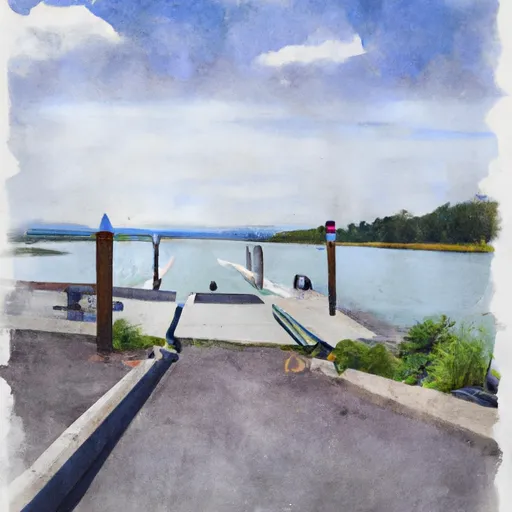
Southeast 296th Street 22601, Black Diamond Boat Launch
Community Reviews
Been here? Share the conditions.
Reviews, ratings & photos are added in the free Snoflo iOS app — rate a spot, tag the conditions, and your visit is verified by location. Add or manage your reviews from the app.
Southeast 296th Street 22601, Black Diamond
This boat ramp is suitable for launching small watercraft, such as fishing boats, kayaks, canoes, and paddleboards. However, it should be noted that motorized boats are also allowed on Lake Sawyer, provided they comply with the lake's speed limit and other regulations.
Overall, Southeast 296th Street 22601 boat ramp is a popular destination for locals and tourists who want to enjoy fishing, boating, and other water-based activities on Lake Sawyer. It is well-maintained and easily accessible, making it an ideal launching point for all types of watercraft.
Plan your launch down to the hour
Same weather feed Snoflo's iOS app uses -- updated continuously from NOAA / yr.no.
Next 5 days, hour by hour
Temperature line with weather symbols on top, snow + rain accumulation as columns, humidity as a dotted line.
5-day forecast table
Every 3 hours, broken out across temperature, snow, rain, humidity, and wind.
| Time | Condition | Temp (°F) | Snow (in) | Rain (in) | Humidity (%) | Wind (mps) | Wind dir |
|---|---|---|---|---|---|---|---|
| Loading detailed forecast… | |||||||
15-day temperature & precipitation
Daily temperatures, snow, and rain projected over the next two weeks.
Area streamflow levels
USGS streamgauges around Southeast 296th Street 22601, Black Diamond -- the same readings that determine whether your launch is safe and your boat is the right craft.
| Streamgauge | Discharge | View |
|---|---|---|
| Rock Creek At Highway 516 Near Ravensdale | 4 cfs | → |
| Rock Creek Near Maple Valley | 2 cfs | → |
| Cedar River Below Diversion Near Landsburg | 137 cfs | → |
| Newaukum Creek Near Black Diamond | 16 cfs | → |
| Cedar River Near Landsburg | 307 cfs | → |
| Big Soos Creek Above Hatchery Near Auburn | 37 cfs | → |
Plan a longer trip
The closest paddle runs, fishing spots, and other boat launches so you can extend a day on the water.
River runs
- Huckleberry Creek To Confluence With Clearwater River
- Snoqualmie Falls To Plum's Landing
- Confluence With Taylor River To Confluence With North Fork Snoqualmie River
- Wagner Bridge To Confluence With Middle Fork Snoqualmie River
- Confluence With Ipsut Creek To Western Boundary Of Mount Rainier National Park
- Mt. Baker-Snoqualmie Nf/Mt. Ranier Np Boundary At North Section Line Of Sec 3, T17 N, R10e To Confluence With Huckleberry Creek
Boating safety & etiquette
- Check the conditions before you launch
- Use the streamflow numbers, weather, and wind forecast on this page. High-cfs whitewater requires whitewater-specific craft and skill.
- Wear your life jacket
- Statistically the single biggest survival factor in a boating incident. State law often requires one per passenger.
- File a float plan
- Tell someone on shore your put-in, take-out, and expected return time. Especially for multi-day or remote trips.
- Yield at the ramp
- Prep gear in the parking lot, not on the ramp. Launch and clear quickly so others can use the lane.
- Clean, drain, dry
- Inspect, clean, drain and dry your boat between waters to prevent the spread of aquatic invasive species.
Set push alerts in the Snoflo app
Save Southeast 296th Street 22601, Black Diamond as a favorite, set a discharge threshold or a wind/precipitation alert, and the iOS app will push the moment conditions cross.
About Southeast 296th Street 22601, Black Diamond
Can I launch a motorboat here?
Most Snoflo-tracked launches support motorboats; check the operator for any horsepower restrictions, paddle-only zones, or seasonal closures.
How fresh is the streamflow data?
USGS streamgauges report continuously (every 15 minutes); the table on this page pulls the latest reading at page load.
Is there a fee?
Many federal and state boat launches charge a day-use fee. Check the operator's site before driving out.
What boat is right for these conditions?
Use the nearby streamflow numbers and river-run panel on this page to gauge current conditions. Wider, slower water is friendly for casual paddling and powerboats; high-cfs whitewater requires whitewater-specific craft and skill.
Can I get alerts when conditions change?
Yes -- alerts are managed in the Snoflo iOS app. Favorite this launch, set a threshold (discharge, wind), and you'll get a push the moment it crosses.
Other launches near here
Snoflo-tracked boat launches within driving distance of Southeast 296th Street 22601, Black Diamond.