Bonita Canyon campground
Community Reviews
Been here? Share the conditions.
Reviews, ratings & photos are added in the free Snoflo iOS app — rate a spot, tag the conditions, and your visit is verified by location. Add or manage your reviews from the app.
Bonita Canyon
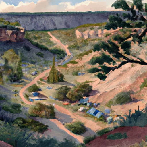
The camping area is surrounded by the Chiricahua Mountains, which are known for their spectacular sunsets. The Faraway Ranch Historic District is just a short walk from the campground, where visitors can learn about the area's history. The area is also home to numerous hiking trails that offer stunning views of the surrounding landscape, including the Heart of Rocks Loop Trail.
The Bonita Canyon campground has several amenities to make your stay as comfortable as possible. The campsite has 24 sites, with each offering a picnic table, fire pit, and access to potable water. There are also vault toilets on site, and a dump station is available for RVs.
The Chiricahua National Monument and the Bonita Canyon camping area have a rich history. The area is home to the Apache Indians, who used the land for hunting and gathering. Later, it became a ranch for pioneers, and now it is a national monument that attracts thousands of visitors each year.
The best time to visit Bonita Canyon is in the spring and fall when temperatures are mild and pleasant. The average temperature in the spring season is around 70°F during the day, and 40°F at night. During the fall season, the average temperature is around 75°F during the day, and 45°F at night.
Overall, the Bonita Canyon camping area is a unique and beautiful destination that offers breathtaking views, rich history, and a wide range of outdoor activities for visitors to enjoy. Whether you're a seasoned camper or a first-timer, this is a must-visit destination for anyone looking to experience the beauty of Arizona's national parks.
What's on-site at Bonita Canyon
Key facilities Snoflo tracks for this campground. Confirm with the operator before booking -- amenities can change seasonally.
Plan your trip down to the hour
Same weather feed Snoflo's iOS app uses -- updated continuously from NOAA / yr.no.
Next 5 days, hour by hour
Temperature line with weather symbols on top, snow + rain accumulation as columns, humidity as a dotted line.
5-day forecast table
Every 3 hours, broken out across temperature, snow, rain, humidity, and wind. Each cell is colour-coded relative to the column min/max so trends jump out at a glance.
| Time | Condition | Temp (°F) | Snow (in) | Rain (in) | Humidity (%) | Wind (mps) | Wind dir |
|---|---|---|---|---|---|---|---|
| Loading detailed forecast… | |||||||
15-day temperature & precipitation
Daily temperatures, snow, and rain projected over the next two weeks. Hover any point for the full breakdown.
Other campgrounds in the area
Snoflo-tracked campsites within driving distance of Bonita Canyon, with reservations status.
| Campground | Reservations | Toilets | View |
|---|---|---|---|
| Bonita Canyon - Chiricahua National Monument | ✗ | ✓ | → |
| Pinery Canyon Campground | ✗ | ✗ | → |
| Pinery Canyon | ✗ | ✓ | → |
| Barfoot Park Campground | ✗ | ✗ | → |
| Fitch Corral Camp | ✗ | ✗ | → |
Nearby streamflow
USGS streamgauges within reach of Bonita Canyon -- pulled live from the National Water Information System.
| Streamgauge | Discharge | View |
|---|---|---|
| Leslie Creek Near Mcneal | · | → |
| Whitewater Draw Near Douglas | 159 cfs | → |
| Gila River At Duncan | 12 cfs | → |
| Banning Creek Near Bisbee | · | → |
| San Pedro River Near Tombstone | 117 cfs | → |
| Gila River Below Blue Creek | 0 cfs | → |
Plan a longer trip
The closest parks, lakes, boat launches, and paddle runs so a camping night can grow into a full weekend.
Parks
- Chiricahua National Monument
- Fort Bowie National Historic Site
- May Memorial Wildlife Area
- Dos Cabezas Mountains Wilderness
- Wilderness Chiricahua
- Peloncillo Mountains Wilderness
Points of interest
- Silver Spur Faraway Trail
- Organ Pipe Formation
- Natural Bridge Viewing Area
- Natural Bridge Trailhead
- National Register Of Historic Places Sign
- Natural Bridge Trailhead Interpretive Sign
Paddle runs
- Cima Creek - Headwaters To Wilderness Boundary
- Cower Cave Creek - Wilderness Boundary To Coronado National Forest Boundary (Near Portal)
- Headwaters Within Wilderness To Wilderness Boundary
- Headwaters To Wilderness Boundary
- Wilderness Boundary To Confluence With Cave Creek
Camping essentials & Leave No Trace
- Pack it in, pack it out
- Take all trash, food scraps, and gear back with you to keep campsites clean and protect wildlife.
- Respect wildlife
- Observe animals from a distance, store food securely, and never feed wildlife to maintain natural behavior and safety.
- Know before you go
- Check weather, fire restrictions, trail conditions, and permit requirements to ensure a safe and well-planned trip.
- Minimize campfire impact
- Use established fire rings, keep fires small, fully extinguish them, or opt for a camp stove when fires are restricted.
- Leave what you find
- Preserve natural and cultural features by avoiding removal of plants, rocks, artifacts, or other elements of the environment.
Set push alerts in the Snoflo app
Save Bonita Canyon as a favorite, set a custom threshold (precipitation, snowpack, freezing temperatures), and the iOS app will push the moment conditions cross.
About Bonita Canyon
Can I make reservations at Bonita Canyon?
This campground does not appear to accept reservations -- it's typically first-come, first-served. Arrive early on summer weekends.
How fresh is the weather data on this page?
The hourly forecast updates throughout the day from the NOAA / yr.no public feeds. Streamflow data is pulled live from USGS streamgauges and snowpack from the NRCS SNOTEL network.
What's the best time of year to visit?
Use the 15-day temperature & precipitation outlook on this page to plan -- pick a window with comfortable temperatures and low precipitation. For longer trips, the 5-day hourly meteogram shows snow + rain accumulation hour-by-hour.
How do I get to Bonita Canyon?
Tap Directions in the hero above to open driving directions in Google Maps, or Open in map to center the Snoflo interactive map on the campground.
Can I get alerts when conditions change?
Yes -- alerts are managed through the Snoflo iOS app. Favorite this campground, set a threshold (temperature, snowpack, precipitation), and you'll get a push the moment it crosses.
Other campgrounds near here
Snoflo-tracked campgrounds within driving distance of Bonita Canyon.