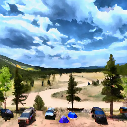
Divide Fork Campground
Community Reviews
Been here? Share the conditions.
Reviews, ratings & photos are added in the free Snoflo iOS app — rate a spot, tag the conditions, and your visit is verified by location. Add or manage your reviews from the app.
Divide Fork
Reservations are accepted at Divide Fork camping area, allowing visitors to secure a spot in advance. It is advisable to make reservations, especially during peak seasons, to ensure availability. The best time of year to visit this campground is during the summer months when the weather is mild, allowing for enjoyable outdoor activities such as hiking, fishing, and wildlife spotting. However, it is important to note that the campground's weather can be unpredictable, so it's always a good idea to pack appropriate gear and clothing for varying conditions.
While exploring Divide Fork camping area, campers can appreciate the stunning natural surroundings and breathtaking views. However, it is essential to be cautious of the local wildlife, including bears and other potentially dangerous animals. Campers should adhere to proper food storage guidelines and avoid leaving any trash or food unattended. It is also advisable to be aware of potential weather changes and prepare accordingly. By following these precautions and enjoying the amenities provided, campers can have a memorable and enjoyable experience at the Divide Fork camping area in Colorado.
What's on-site at Divide Fork
Key facilities Snoflo tracks for this campground. Confirm with the operator before booking -- amenities can change seasonally.
Plan your trip down to the hour
Same weather feed Snoflo's iOS app uses -- updated continuously from NOAA / yr.no.
Next 5 days, hour by hour
Temperature line with weather symbols on top, snow + rain accumulation as columns, humidity as a dotted line.
5-day forecast table
Every 3 hours, broken out across temperature, snow, rain, humidity, and wind. Each cell is colour-coded relative to the column min/max so trends jump out at a glance.
| Time | Condition | Temp (°F) | Snow (in) | Rain (in) | Humidity (%) | Wind (mps) | Wind dir |
|---|---|---|---|---|---|---|---|
| Loading detailed forecast… | |||||||
15-day temperature & precipitation
Daily temperatures, snow, and rain projected over the next two weeks. Hover any point for the full breakdown.
Other campgrounds in the area
Snoflo-tracked campsites within driving distance of Divide Fork, with reservations status.
| Campground | Reservations | Toilets | View |
|---|---|---|---|
| Divide Forks Campground - Grand Valley Rd | ✓ | ✗ | → |
| Aspen Leaf Cabin | ✓ | ✗ | → |
| Dominguez Campground | ✗ | ✗ | → |
| Big Dominguez | ✗ | ✗ | → |
| Big Dominguez Campground | ✗ | ✗ | → |
Nearby streamflow
USGS streamgauges within reach of Divide Fork -- pulled live from the National Water Information System.
| Streamgauge | Discharge | View |
|---|---|---|
| Dolores River Near Gateway | 17 cfs | → |
| San Miguel River At Uravan | 26 cfs | → |
| Dolores River Near Bedrock | 16 cfs | → |
| Gunnison River Near Grand Junction | 2,230 cfs | → |
| Dolores River At Bedrock | 37 cfs | → |
| Dolores River Near Cisco | 32 cfs | → |
Nearby snow depths
NRCS SNOTEL stations within reach of Divide Fork -- relevant when planning a shoulder-season or alpine trip.
| SNOTEL station | Snowpack | 24h Snowfall | View |
|---|---|---|---|
| Columbine Pass | 0.0 in | 0.0 in | → |
| Nohrsc Columbine Pass | 0.0 in | 0.0 in | → |
| Redlands 1.4 Sse | 0.0 in | 0.0 in | → |
| Glade Park | 0.0 in | 0.0 in | → |
| Grand Junction 3.6 W | 0.0 in | 0.0 in | → |
| Grand Junction 4.0 W | 0.0 in | 0.0 in | → |
Plan a longer trip
The closest parks, lakes, boat launches, and paddle runs so a camping night can grow into a full weekend.
Parks
- Dominguez-Escalante National Conservation Area
- Colorado National Monument
- James M Robb Colorado River State Park
- Columbine Park
- Nucla Town Park
- Grand Mesa National Forest
Boat launches
- Whitewater Boat Launch
- State Highway 141 Mesa County
- Escalante Canyon Road Delta County
- Escalante Boat Launch
- Redlands Dam River Access
Fishing spots
Camping essentials & Leave No Trace
- Pack it in, pack it out
- Take all trash, food scraps, and gear back with you to keep campsites clean and protect wildlife.
- Respect wildlife
- Observe animals from a distance, store food securely, and never feed wildlife to maintain natural behavior and safety.
- Know before you go
- Check weather, fire restrictions, trail conditions, and permit requirements to ensure a safe and well-planned trip.
- Minimize campfire impact
- Use established fire rings, keep fires small, fully extinguish them, or opt for a camp stove when fires are restricted.
- Leave what you find
- Preserve natural and cultural features by avoiding removal of plants, rocks, artifacts, or other elements of the environment.
Set push alerts in the Snoflo app
Save Divide Fork as a favorite, set a custom threshold (precipitation, snowpack, freezing temperatures), and the iOS app will push the moment conditions cross.
About Divide Fork
Can I make reservations at Divide Fork?
This campground does not appear to accept reservations -- it's typically first-come, first-served. Arrive early on summer weekends.
How fresh is the weather data on this page?
The hourly forecast updates throughout the day from the NOAA / yr.no public feeds. Streamflow data is pulled live from USGS streamgauges and snowpack from the NRCS SNOTEL network.
What's the best time of year to visit?
Use the 15-day temperature & precipitation outlook on this page to plan -- pick a window with comfortable temperatures and low precipitation. For longer trips, the 5-day hourly meteogram shows snow + rain accumulation hour-by-hour.
How do I get to Divide Fork?
Tap Directions in the hero above to open driving directions in Google Maps, or Open in map to center the Snoflo interactive map on the campground.
Can I get alerts when conditions change?
Yes -- alerts are managed through the Snoflo iOS app. Favorite this campground, set a threshold (temperature, snowpack, precipitation), and you'll get a push the moment it crosses.
Other campgrounds near here
Snoflo-tracked campgrounds within driving distance of Divide Fork.