The Crags - State Forest State Park Campground
Community Reviews
Been here? Share the conditions.
Reviews, ratings & photos are added in the free Snoflo iOS app — rate a spot, tag the conditions, and your visit is verified by location. Add or manage your reviews from the app.
The Crags - State Forest State Park
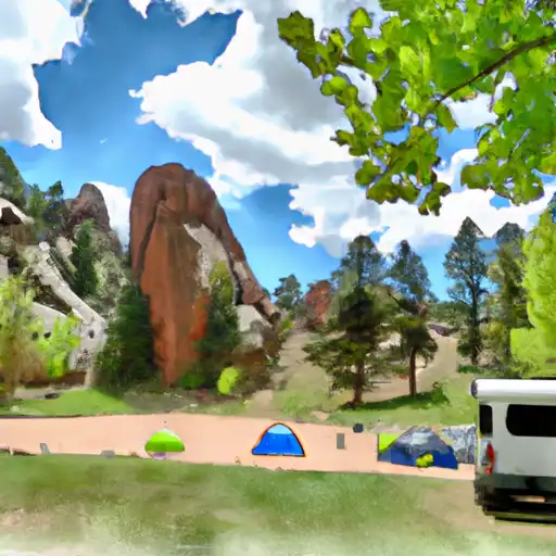
There are plenty of nearby points of interest to explore, including the Yampa River Botanic Park, Fish Creek Falls, and Steamboat Ski Resort. The park itself boasts a variety of amenities, including picnic areas, hiking trails, and fishing spots. There are also campsites available, with options for both tents and RVs. Reservations are required, and there are a total of 12 campsites.
An interesting fact about the area is that it was once inhabited by the Ute tribe. The park is named after the rock formations, which were said to resemble crags by the Ute people.
The best time of year to visit Crags State Forest State Park is during the summer months, with average temperatures ranging from the mid-70s to mid-80s Fahrenheit. Visitors can enjoy hiking, fishing, and other outdoor activities in the beautiful Colorado wilderness.
What's on-site at The Crags - State Forest State Park
Key facilities Snoflo tracks for this campground. Confirm with the operator before booking -- amenities can change seasonally.
Plan your trip down to the hour
Same weather feed Snoflo's iOS app uses -- updated continuously from NOAA / yr.no.
Next 5 days, hour by hour
Temperature line with weather symbols on top, snow + rain accumulation as columns, humidity as a dotted line.
5-day forecast table
Every 3 hours, broken out across temperature, snow, rain, humidity, and wind. Each cell is colour-coded relative to the column min/max so trends jump out at a glance.
| Time | Condition | Temp (°F) | Snow (in) | Rain (in) | Humidity (%) | Wind (mps) | Wind dir |
|---|---|---|---|---|---|---|---|
| Loading detailed forecast… | |||||||
15-day temperature & precipitation
Daily temperatures, snow, and rain projected over the next two weeks. Hover any point for the full breakdown.
Other campgrounds in the area
Snoflo-tracked campsites within driving distance of The Crags - State Forest State Park, with reservations status.
| Campground | Reservations | Toilets | View |
|---|---|---|---|
| Crags Campground | ✗ | ✗ | → |
| Box Canyon Campsite | ✗ | ✗ | → |
| Skeleton Gultch | ✗ | ✗ | → |
| Ditch Camp Group/Stock Site | ✗ | ✗ | → |
| Ditch Camp Individual Site | ✗ | ✗ | → |
Nearby streamflow
USGS streamgauges within reach of The Crags - State Forest State Park -- pulled live from the National Water Information System.
| Streamgauge | Discharge | View |
|---|---|---|
| Michigan River Near Cameron Pass | 1 cfs | → |
| Joe Wright Creek Above Joe Wright Reservoir | 3 cfs | → |
| Grand River Ditch At La Poudre Pass | 25 cfs | → |
| Joe Wright Creek Below Joe Wright Reservoir | 9 cfs | → |
| Colorado R Below Baker Gulch | 26 cfs | → |
| Illinois Creek Near Rand | 1 cfs | → |
Nearby snow depths
NRCS SNOTEL stations within reach of The Crags - State Forest State Park -- relevant when planning a shoulder-season or alpine trip.
| SNOTEL station | Snowpack | 24h Snowfall | View |
|---|---|---|---|
| Cameron Pass | 3.4 in | 0.0 in | → |
| Nohrsc Joe Wright | 5.0 in | 0.0 in | → |
| Joe Wright | 4.0 in | 0.0 in | → |
| Co St Forest St Park | 0.0 in | 0.0 in | → |
| Nohrsc Long Draw Resvr Snotel | 0.0 in | 0.0 in | → |
| Long Draw Resv | 0.0 in | 0.0 in | → |
Plan a longer trip
The closest parks, lakes, boat launches, and paddle runs so a camping night can grow into a full weekend.
Parks
- State Forest State Park
- Rawah Wilderness
- Neota Wilderness
- Wilderness Never Summer
- Comanche Peak Wilderness
- Cache La Poudre Wilderness
Boat launches
- State Forest State Park
- Chambers Lake Boating Site
- Hilltop Boating Site
- Boat Launch Grand Lake
- Grand County
Fishing spots
- Zimmerman Lake
- Joe Wright Reservoir
- Joe Wright Fishing Site
- Ranger Lakes
- Long Draw #3 Fishing Site
- Long Draw #2 Fishing Site
Points of interest
- Alpine Visitor Center
- Holzwarth Historic Site
- Old Fall River Road
- Trail Ridge Road Scenic Byway
- Kawuneeche Visitor Center
- Fall River Visitor Center
Paddle runs
- Begins 0.5 Miles Away From Trail Ridge Road To Ends Where River Segment Exits Rocky Mountain National Park
- Big South
- Headwaters To Ends 0.5 Miles Upstream From End Of Fern Lake Road
- Headwaters To Fan Lake
- Spencer Heights
- Headwaters To Boundary Of Rocky Mountain National Park
Camping essentials & Leave No Trace
- Pack it in, pack it out
- Take all trash, food scraps, and gear back with you to keep campsites clean and protect wildlife.
- Respect wildlife
- Observe animals from a distance, store food securely, and never feed wildlife to maintain natural behavior and safety.
- Know before you go
- Check weather, fire restrictions, trail conditions, and permit requirements to ensure a safe and well-planned trip.
- Minimize campfire impact
- Use established fire rings, keep fires small, fully extinguish them, or opt for a camp stove when fires are restricted.
- Leave what you find
- Preserve natural and cultural features by avoiding removal of plants, rocks, artifacts, or other elements of the environment.
Set push alerts in the Snoflo app
Save The Crags - State Forest State Park as a favorite, set a custom threshold (precipitation, snowpack, freezing temperatures), and the iOS app will push the moment conditions cross.
About The Crags - State Forest State Park
Can I make reservations at The Crags - State Forest State Park?
Yes -- this campground accepts reservations. Snoflo recommends booking early for peak season; check the operator (Recreation.gov / state park system / private operator) for the booking window and cancellation policy.
How fresh is the weather data on this page?
The hourly forecast updates throughout the day from the NOAA / yr.no public feeds. Streamflow data is pulled live from USGS streamgauges and snowpack from the NRCS SNOTEL network.
What's the best time of year to visit?
Use the 15-day temperature & precipitation outlook on this page to plan -- pick a window with comfortable temperatures and low precipitation. For longer trips, the 5-day hourly meteogram shows snow + rain accumulation hour-by-hour.
How do I get to The Crags - State Forest State Park?
Tap Directions in the hero above to open driving directions in Google Maps, or Open in map to center the Snoflo interactive map on the campground.
Can I get alerts when conditions change?
Yes -- alerts are managed through the Snoflo iOS app. Favorite this campground, set a threshold (temperature, snowpack, precipitation), and you'll get a push the moment it crosses.
Other campgrounds near here
Snoflo-tracked campgrounds within driving distance of The Crags - State Forest State Park.