Rock Creek Primitive Camp Campground
Community Reviews
Been here? Share the conditions.
Reviews, ratings & photos are added in the free Snoflo iOS app — rate a spot, tag the conditions, and your visit is verified by location. Add or manage your reviews from the app.
Rock Creek Primitive Camp
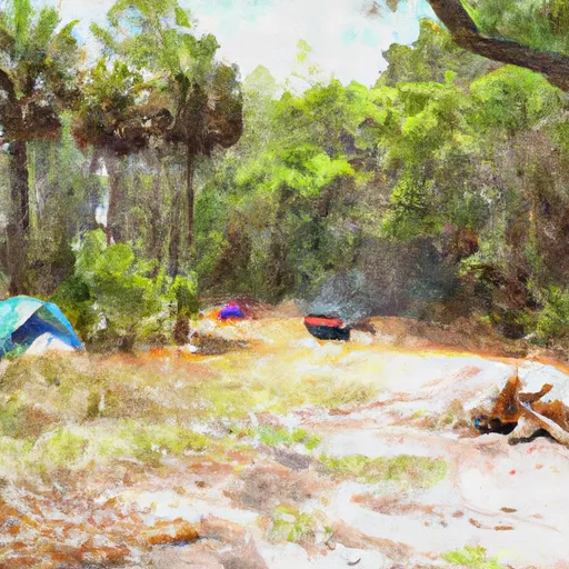
As a primitive camp, Rock Creek does not offer any specific amenities, so campers must come fully prepared with their own food, water, and camping equipment. Additionally, campfires are allowed at designated fire rings, making it a great spot for those who enjoy cooking over an open flame.
Reservations are not accepted at Rock Creek Primitive Camp, and campsites are available on a first-come, first-served basis. It is recommended to arrive early, especially during peak seasons, to secure a campsite.
The best time to visit Rock Creek Primitive Camp is during the cooler months, from October to April, when temperatures are more comfortable for outdoor activities. During this time, campers can enjoy activities like hiking, fishing, and birdwatching.
However, it is important to note that the campsite is prone to flooding during periods of heavy rain, so it is advisable to check the weather forecast before planning a trip. Additionally, being a primitive camp, there are no restroom facilities, so campers must practice Leave No Trace principles and properly dispose of waste. Overall, Rock Creek Primitive Camp offers a rustic and secluded camping experience for those seeking to immerse themselves in nature.
What's on-site at Rock Creek Primitive Camp
Key facilities Snoflo tracks for this campground. Confirm with the operator before booking -- amenities can change seasonally.
Plan your trip down to the hour
Same weather feed Snoflo's iOS app uses -- updated continuously from NOAA / yr.no.
Next 5 days, hour by hour
Temperature line with weather symbols on top, snow + rain accumulation as columns, humidity as a dotted line.
5-day forecast table
Every 3 hours, broken out across temperature, snow, rain, humidity, and wind. Each cell is colour-coded relative to the column min/max so trends jump out at a glance.
| Time | Condition | Temp (°F) | Snow (in) | Rain (in) | Humidity (%) | Wind (mps) | Wind dir |
|---|---|---|---|---|---|---|---|
| Loading detailed forecast… | |||||||
15-day temperature & precipitation
Daily temperatures, snow, and rain projected over the next two weeks. Hover any point for the full breakdown.
Other campgrounds in the area
Snoflo-tracked campsites within driving distance of Rock Creek Primitive Camp, with reservations status.
| Campground | Reservations | Toilets | View |
|---|---|---|---|
| Torreya State Park | ✓ | ✗ | → |
| Rock Bluff Primitive Camp | ✗ | ✗ | → |
| Torreya Challenge Primitive Camp | ✗ | ✗ | → |
| Triple C'S Campground And Rv Park | ✗ | ✗ | → |
| Chattahoochee City Park | ✗ | ✗ | → |
Nearby streamflow
USGS streamgauges within reach of Rock Creek Primitive Camp -- pulled live from the National Water Information System.
| Streamgauge | Discharge | View |
|---|---|---|
| Apalachicola River At Chattahoochee Fla | 11,400 cfs | → |
| Telogia Creek Nr Bristol | 85 cfs | → |
| Apalachicola River Nr Blountstown | 12,800 cfs | → |
| Chipola River Nr Altha | 1,250 cfs | → |
| Chipola River At Marianna Fl | 495 cfs | → |
| Ochlockonee River Nr Bloxham | 663 cfs | → |
Nearby snow depths
NRCS SNOTEL stations within reach of Rock Creek Primitive Camp -- relevant when planning a shoulder-season or alpine trip.
| SNOTEL station | Snowpack | 24h Snowfall | View |
|---|---|---|---|
| Marianna 7 Ne | 6.0 in | 4.0 in | → |
| Marianna 0.8 Nne | 0.0 in | 0.0 in | → |
| Havana 4.2 Sw | 0.0 in | 0.0 in | → |
| Fountain 3.4 Sse | 0.0 in | 0.0 in | → |
| Havana 5.5 Ne | 0.0 in | 0.0 in | → |
| Pansey 1.6 Nne | 0.0 in | 0.0 in | → |
Plan a longer trip
The closest parks, lakes, boat launches, and paddle runs so a camping night can grow into a full weekend.
Parks
- Torreya State Park
- Beaverdam Creek Wildlife Management Area
- Apalachicola Bluffs And Ravines Preserve
- Three Rivers State Park
- Apalachee Wildlife Management Area
- Sam Atkins Park
Boat launches
- Land Store Road, Grand Ridge
- John Redd East Road Calhoun County
- Beaverdam Creek Tract - Harry Donar Landing
- Ocheesee Pond Public Boat Ramp
- Gulf Power Boat Ramp
- Clyde Hopkins Park Public Boat Ramp
Fishing spots
Points of interest
Paddle runs
- 2 Miles Below Dam On Lake Talquin To Ochlockonee Bay
- Segment B--Sh 65 To Carr Bridge On Fh 13
- Headwaters To Concrete Bridge (Burnt Bridge) On Fh 13 (Where River Enters Bradwell Ray Wilderness)
- Segment C--Mud Swamp/New River Wilderness Boundary To Mud Swamp/New River Wilderness (Southern) Boundary
- Bradwell Bay Wilderness (Northern Boundary) To Bradwell Bay Wilderness Boundary At Trice Bridge On Fr 329
- Tirce Creek Bridge (Monkey Creek) To Forest Service Property Boundary In Sec 13
Camping essentials & Leave No Trace
- Pack it in, pack it out
- Take all trash, food scraps, and gear back with you to keep campsites clean and protect wildlife.
- Respect wildlife
- Observe animals from a distance, store food securely, and never feed wildlife to maintain natural behavior and safety.
- Know before you go
- Check weather, fire restrictions, trail conditions, and permit requirements to ensure a safe and well-planned trip.
- Minimize campfire impact
- Use established fire rings, keep fires small, fully extinguish them, or opt for a camp stove when fires are restricted.
- Leave what you find
- Preserve natural and cultural features by avoiding removal of plants, rocks, artifacts, or other elements of the environment.
Set push alerts in the Snoflo app
Save Rock Creek Primitive Camp as a favorite, set a custom threshold (precipitation, snowpack, freezing temperatures), and the iOS app will push the moment conditions cross.
About Rock Creek Primitive Camp
Can I make reservations at Rock Creek Primitive Camp?
This campground does not appear to accept reservations -- it's typically first-come, first-served. Arrive early on summer weekends.
How fresh is the weather data on this page?
The hourly forecast updates throughout the day from the NOAA / yr.no public feeds. Streamflow data is pulled live from USGS streamgauges and snowpack from the NRCS SNOTEL network.
What's the best time of year to visit?
Use the 15-day temperature & precipitation outlook on this page to plan -- pick a window with comfortable temperatures and low precipitation. For longer trips, the 5-day hourly meteogram shows snow + rain accumulation hour-by-hour.
How do I get to Rock Creek Primitive Camp?
Tap Directions in the hero above to open driving directions in Google Maps, or Open in map to center the Snoflo interactive map on the campground.
Can I get alerts when conditions change?
Yes -- alerts are managed through the Snoflo iOS app. Favorite this campground, set a threshold (temperature, snowpack, precipitation), and you'll get a push the moment it crosses.
Other campgrounds near here
Snoflo-tracked campgrounds within driving distance of Rock Creek Primitive Camp.