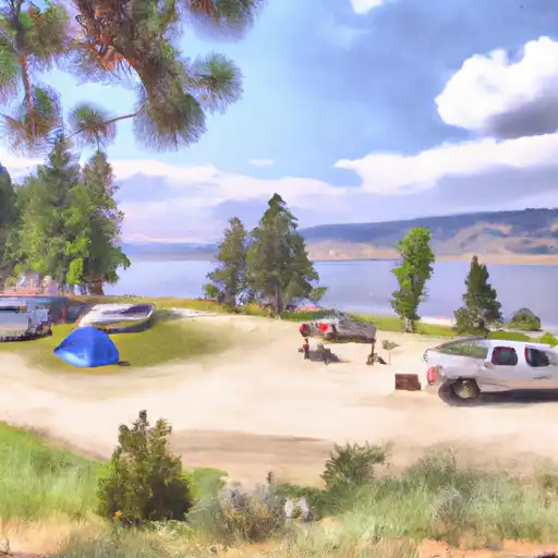
Picnic Point Campground
Community Reviews
Been here? Share the conditions.
Reviews, ratings & photos are added in the free Snoflo iOS app — rate a spot, tag the conditions, and your visit is verified by location. Add or manage your reviews from the app.
Picnic Point
Reservations are accepted at Picnic Point camping area, allowing campers to secure their spot in advance. This is particularly important during peak seasons when the campground tends to get crowded. It is advisable to make reservations early to avoid any inconvenience.
The best time to visit Picnic Point camping area is during the summer months, from June to September, when the weather is pleasant and activities such as hiking, fishing, and wildlife viewing can be enjoyed to the fullest. The surrounding natural beauty, including stunning views of the nearby lake and mountains, provides a breathtaking backdrop for outdoor enthusiasts.
While visiting Picnic Point camping area, it is important to be cautious of wildlife encounters, as the area is known for its diverse range of animals. It is recommended to store food and trash properly to minimize the risk of attracting bears or other wildlife. Additionally, campers should be mindful of fire safety and adhere to any regulations regarding campfires to prevent wildfires.
In conclusion, Picnic Point camping area in Idaho offers a range of amenities for campers, accepts reservations, and is best visited during the summer months. Visitors can enjoy various outdoor activities while appreciating the stunning natural beauty. However, campers should be cautious of wildlife encounters and adhere to fire safety regulations.
What's on-site at Picnic Point
Key facilities Snoflo tracks for this campground. Confirm with the operator before booking -- amenities can change seasonally.
Plan your trip down to the hour
Same weather feed Snoflo's iOS app uses -- updated continuously from NOAA / yr.no.
Next 5 days, hour by hour
Temperature line with weather symbols on top, snow + rain accumulation as columns, humidity as a dotted line.
5-day forecast table
Every 3 hours, broken out across temperature, snow, rain, humidity, and wind. Each cell is colour-coded relative to the column min/max so trends jump out at a glance.
| Time | Condition | Temp (°F) | Snow (in) | Rain (in) | Humidity (%) | Wind (mps) | Wind dir |
|---|---|---|---|---|---|---|---|
| Loading detailed forecast… | |||||||
15-day temperature & precipitation
Daily temperatures, snow, and rain projected over the next two weeks. Hover any point for the full breakdown.
Other campgrounds in the area
Snoflo-tracked campsites within driving distance of Picnic Point, with reservations status.
| Campground | Reservations | Toilets | View |
|---|---|---|---|
| Shoreline Campground And Group Sites - Reserve | ✓ | ✗ | → |
| Picnic Point Campground - Reserve | ✓ | ✗ | → |
| Shoreline | ✓ | ✓ | → |
| Warm Lake Campground - Reserve | ✓ | ✗ | → |
| Warm Lake | ✓ | ✓ | → |
Nearby streamflow
USGS streamgauges within reach of Picnic Point -- pulled live from the National Water Information System.
| Streamgauge | Discharge | View |
|---|---|---|
| Johnson Creek At Yellow Pine Id | 111 cfs | → |
| Sf Salmon River Nr Krassel Ranger Station Id | 171 cfs | → |
| Ef Of Sf Salmon River At Stibnite Id | 46 cfs | → |
| Lake Fork Payette River Ab Jumbo Cr Nr Mccall Id | 35 cfs | → |
| Deadwood River Bl Deadwood Res Nr Lowman Id | 731 cfs | → |
| Efsf Salmon R Abv Sugar Crk Nr Stibnite | 82 cfs | → |
Nearby snow depths
NRCS SNOTEL stations within reach of Picnic Point -- relevant when planning a shoulder-season or alpine trip.
| SNOTEL station | Snowpack | 24h Snowfall | View |
|---|---|---|---|
| Big Creek Summit | 0.0 in | 0.0 in | → |
| Nohrsc Big Creek Summit | 0.0 in | 0.0 in | → |
| Nohrsc Deadwood Summit | 4.0 in | 0.0 in | → |
| Deadwood Summit | 5.0 in | 1.0 in | → |
| Deadwood Lodge | 53.0 in | 0.0 in | → |
| Shaw Twin | 8.3 in | 0.0 in | → |
Plan a longer trip
The closest parks, lakes, boat launches, and paddle runs so a camping night can grow into a full weekend.
Parks
- Horsethief Reservoir Recreation Area
- Ponderosa State Park
- Wilderness Frank Church - River Of No Return
- Packer John's Cabin State Park
Boat launches
Fishing spots
Paddle runs
- Secesh To Main (The Canyon)
- Headwaters To Junction Fr 447
- Junction Fr 447 To Confluence With Johnson Creek
- Confluence With Bear Creek To Confluence With Hanson Creek
- Headwaters To Confluence With Elk Creek
- Fcronr Wilderness Boundary To Confluence With North Fork Elk Creek
Camping essentials & Leave No Trace
- Pack it in, pack it out
- Take all trash, food scraps, and gear back with you to keep campsites clean and protect wildlife.
- Respect wildlife
- Observe animals from a distance, store food securely, and never feed wildlife to maintain natural behavior and safety.
- Know before you go
- Check weather, fire restrictions, trail conditions, and permit requirements to ensure a safe and well-planned trip.
- Minimize campfire impact
- Use established fire rings, keep fires small, fully extinguish them, or opt for a camp stove when fires are restricted.
- Leave what you find
- Preserve natural and cultural features by avoiding removal of plants, rocks, artifacts, or other elements of the environment.
Set push alerts in the Snoflo app
Save Picnic Point as a favorite, set a custom threshold (precipitation, snowpack, freezing temperatures), and the iOS app will push the moment conditions cross.
About Picnic Point
Can I make reservations at Picnic Point?
This campground does not appear to accept reservations -- it's typically first-come, first-served. Arrive early on summer weekends.
How fresh is the weather data on this page?
The hourly forecast updates throughout the day from the NOAA / yr.no public feeds. Streamflow data is pulled live from USGS streamgauges and snowpack from the NRCS SNOTEL network.
What's the best time of year to visit?
Use the 15-day temperature & precipitation outlook on this page to plan -- pick a window with comfortable temperatures and low precipitation. For longer trips, the 5-day hourly meteogram shows snow + rain accumulation hour-by-hour.
How do I get to Picnic Point?
Tap Directions in the hero above to open driving directions in Google Maps, or Open in map to center the Snoflo interactive map on the campground.
Can I get alerts when conditions change?
Yes -- alerts are managed through the Snoflo iOS app. Favorite this campground, set a threshold (temperature, snowpack, precipitation), and you'll get a push the moment it crosses.
Other campgrounds near here
Snoflo-tracked campgrounds within driving distance of Picnic Point.