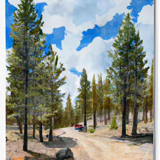
Three Pines Campground
Community Reviews
Been here? Share the conditions.
Reviews, ratings & photos are added in the free Snoflo iOS app — rate a spot, tag the conditions, and your visit is verified by location. Add or manage your reviews from the app.
Three Pines
The campground itself is equipped with basic amenities such as restrooms, picnic tables, and fire pits, but does not offer electricity or showers. The camping area operates on a first-come-first-serve basis and has 16 primitive campsites available for visitors.
An interesting fact about the Three Pines Camping area is that it is known for its abundance of huckleberries, which can be found throughout the forest during the late summer months. Visitors are welcome to pick and eat the fruit, or even use it to make their own homemade jams and pies.
The best time of year to visit the Three Pines Camping Area is during the summer months, as the average temperature from June to August ranges from 70 to 80 degrees Fahrenheit. The warm weather and stunning views of the surrounding mountains make it the perfect destination for outdoor enthusiasts looking to hike, fish, or simply relax in nature.
What's on-site at Three Pines
Key facilities Snoflo tracks for this campground. Confirm with the operator before booking -- amenities can change seasonally.
Plan your trip down to the hour
Same weather feed Snoflo's iOS app uses -- updated continuously from NOAA / yr.no.
Next 5 days, hour by hour
Temperature line with weather symbols on top, snow + rain accumulation as columns, humidity as a dotted line.
5-day forecast table
Every 3 hours, broken out across temperature, snow, rain, humidity, and wind. Each cell is colour-coded relative to the column min/max so trends jump out at a glance.
| Time | Condition | Temp (°F) | Snow (in) | Rain (in) | Humidity (%) | Wind (mps) | Wind dir |
|---|---|---|---|---|---|---|---|
| Loading detailed forecast… | |||||||
15-day temperature & precipitation
Daily temperatures, snow, and rain projected over the next two weeks. Hover any point for the full breakdown.
Other campgrounds in the area
Snoflo-tracked campsites within driving distance of Three Pines, with reservations status.
| Campground | Reservations | Toilets | View |
|---|---|---|---|
| Silver | ✗ | ✗ | → |
| Kalispell Island Group Site And Other Campgrounds | ✓ | ✗ | → |
| Schneider | ✗ | ✗ | → |
| Rocky Point | ✗ | ✗ | → |
| North Cove | ✗ | ✗ | → |
Nearby streamflow
USGS streamgauges within reach of Three Pines -- pulled live from the National Water Information System.
| Streamgauge | Discharge | View |
|---|---|---|
| Priest R Outflow Nr Coolin | 168 cfs | → |
| Pack River Nr Colburn Id | 610 cfs | → |
| Priest River Nr Priest River Id | 276 cfs | → |
| Kootenai River @ Tribal Hatchery Nr Bonners Ferry | 15,700 cfs | → |
| Outlet Creek Near Metaline Falls | 19 cfs | → |
| Pend Oreille River At Newport Wa | 13,300 cfs | → |
Nearby snow depths
NRCS SNOTEL stations within reach of Three Pines -- relevant when planning a shoulder-season or alpine trip.
| SNOTEL station | Snowpack | 24h Snowfall | View |
|---|---|---|---|
| Nohrsc Bunchgrass Mdw | 1.0 in | 0.0 in | → |
| Bunchgrass Mdw | 0.0 in | -1.0 in | → |
| Schweitzer Basin | 0.0 in | 0.0 in | → |
| Schweitzer Basin | 0.0 in | 0.0 in | → |
| Myrtle Creek | 0.0 in | 0.0 in | → |
| Myrtle Creek | 0.0 in | 0.0 in | → |
Plan a longer trip
The closest parks, lakes, boat launches, and paddle runs so a camping night can grow into a full weekend.
Parks
- Priest Lake State Park
- Natural Area Tepee Creek
- Wilderness Salmo-Priest
- Kootenai National Wildlife Refuge
- Lake Newport State Park
- Round Lake State Park
Boat launches
Points of interest
- Indian Rock
- Priest Lake Museum
- Caribou Mountain Lodge
- Bonner County Museum & Arboretum
- Kbfi-Am (Bonners Ferry)
- Pend Oreille County Historical Museum
Paddle runs
- Forest Boundary, Sec. 34, T59n, R2w To Harrison Lake, Sec. 31, T62n, R2w
- Upper Priest River
- Segment 2 Flows For Almost 10 Miles From The Intersection With Trail 312 To Its Confluence With The Upper Priest River To Segment 2 Flows For Almost 10 Miles From The Intersection With Trail 312 To Its Confluence With The Upper Priest River
- Segment 1 Is Classified As Wild And Flows From Its Source For Almost Five Miles To The Intersection With Trail 312 To Segment 1 Is Classified As Wild And Flows From Its Source For Almost To The Intersection With Trail 312
- Long Canyon Pass, Sec. 30, T63n, R2w To Forest Boundary, Road #417, Sec. 25, T63n, R2w
- Ne1/4 Of Sec 13, T40n, R46e To Nw1/4 Of Sec 5, T40n, R46e
Camping essentials & Leave No Trace
- Pack it in, pack it out
- Take all trash, food scraps, and gear back with you to keep campsites clean and protect wildlife.
- Respect wildlife
- Observe animals from a distance, store food securely, and never feed wildlife to maintain natural behavior and safety.
- Know before you go
- Check weather, fire restrictions, trail conditions, and permit requirements to ensure a safe and well-planned trip.
- Minimize campfire impact
- Use established fire rings, keep fires small, fully extinguish them, or opt for a camp stove when fires are restricted.
- Leave what you find
- Preserve natural and cultural features by avoiding removal of plants, rocks, artifacts, or other elements of the environment.
Set push alerts in the Snoflo app
Save Three Pines as a favorite, set a custom threshold (precipitation, snowpack, freezing temperatures), and the iOS app will push the moment conditions cross.
About Three Pines
Can I make reservations at Three Pines?
This campground does not appear to accept reservations -- it's typically first-come, first-served. Arrive early on summer weekends.
How fresh is the weather data on this page?
The hourly forecast updates throughout the day from the NOAA / yr.no public feeds. Streamflow data is pulled live from USGS streamgauges and snowpack from the NRCS SNOTEL network.
What's the best time of year to visit?
Use the 15-day temperature & precipitation outlook on this page to plan -- pick a window with comfortable temperatures and low precipitation. For longer trips, the 5-day hourly meteogram shows snow + rain accumulation hour-by-hour.
How do I get to Three Pines?
Tap Directions in the hero above to open driving directions in Google Maps, or Open in map to center the Snoflo interactive map on the campground.
Can I get alerts when conditions change?
Yes -- alerts are managed through the Snoflo iOS app. Favorite this campground, set a threshold (temperature, snowpack, precipitation), and you'll get a push the moment it crosses.
Other campgrounds near here
Snoflo-tracked campgrounds within driving distance of Three Pines.