Beaverdam Campground And Picnic Area Campground
Community Reviews
Been here? Share the conditions.
Reviews, ratings & photos are added in the free Snoflo iOS app — rate a spot, tag the conditions, and your visit is verified by location. Add or manage your reviews from the app.
Beaverdam Campground And Picnic Area
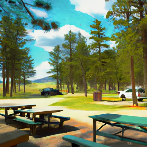
Reservations are not accepted at Beaverdam Campground and Picnic Area, which means that campsites are available on a first-come, first-served basis. It is advisable to arrive early, especially during peak camping seasons, to secure a spot. The best time of year to visit this camping area is typically during the warmer months, from May to September, when the weather is ideal for outdoor activities and exploring the surrounding natural beauty.
While enjoying your stay at Beaverdam Campground, there are several notable attractions to explore. The campground is located near Beaverdam Reservoir, offering opportunities for fishing and boating. Visitors can also embark on scenic hikes in the nearby Beaverhead-Deerlodge National Forest, immersing themselves in the stunning wilderness. However, it is essential to be cautious of wildlife encounters and to practice safe food storage to avoid attracting animals to the campsite.
In summary, Beaverdam Campground and Picnic Area in Montana provides campers with a serene camping experience amidst breathtaking natural surroundings. Although reservations are not accepted, the campground offers amenities such as picnic tables, fire rings, and vault toilets. The best time to visit is from May to September when the weather is favorable, and nearby attractions like Beaverdam Reservoir and Beaverhead-Deerlodge National Forest await exploration. Caution should be exercised regarding wildlife encounters and responsible food storage to ensure a safe and enjoyable camping experience.
What's on-site at Beaverdam Campground And Picnic Area
Key facilities Snoflo tracks for this campground. Confirm with the operator before booking -- amenities can change seasonally.
Plan your trip down to the hour
Same weather feed Snoflo's iOS app uses -- updated continuously from NOAA / yr.no.
Next 5 days, hour by hour
Temperature line with weather symbols on top, snow + rain accumulation as columns, humidity as a dotted line.
5-day forecast table
Every 3 hours, broken out across temperature, snow, rain, humidity, and wind. Each cell is colour-coded relative to the column min/max so trends jump out at a glance.
| Time | Condition | Temp (°F) | Snow (in) | Rain (in) | Humidity (%) | Wind (mps) | Wind dir |
|---|---|---|---|---|---|---|---|
| Loading detailed forecast… | |||||||
15-day temperature & precipitation
Daily temperatures, snow, and rain projected over the next two weeks. Hover any point for the full breakdown.
Other campgrounds in the area
Snoflo-tracked campsites within driving distance of Beaverdam Campground And Picnic Area, with reservations status.
| Campground | Reservations | Toilets | View |
|---|---|---|---|
| Beaverdam | ✗ | ✓ | → |
| Fleecer Cabin | ✓ | ✗ | → |
| Greenwood Bottoms Fas | ✗ | ✗ | → |
| High Rye Cabin | ✓ | ✗ | → |
| Divide Bridge | ✗ | ✗ | → |
Nearby streamflow
USGS streamgauges within reach of Beaverdam Campground And Picnic Area -- pulled live from the National Water Information System.
| Streamgauge | Discharge | View |
|---|---|---|
| Big Hole River At Maiden Rock Nr Divide Mt | 684 cfs | → |
| Silver Bow Cr Bl Blacktail Cr At Butte Mt | 13 cfs | → |
| Big Hole River Near Wise River Mt | 112 cfs | → |
| Blacktail Creek At Butte Mt | 16 cfs | → |
| Willow Creek At Opportunity | 7 cfs | → |
| Silver Bow Creek At Opportunity Mt | 20 cfs | → |
Nearby snow depths
NRCS SNOTEL stations within reach of Beaverdam Campground And Picnic Area -- relevant when planning a shoulder-season or alpine trip.
| SNOTEL station | Snowpack | 24h Snowfall | View |
|---|---|---|---|
| Nohrsc Basin Creek | 0.0 in | 0.0 in | → |
| Basin Creek | 0.0 in | 0.0 in | → |
| Anaconda | 0.0 in | 0.0 in | → |
| Nohrsc Barker Lakes | 0.0 in | 0.0 in | → |
| Barker Lakes | 0.0 in | 0.0 in | → |
| Anaconda 7.4 Nw | 0.0 in | 0.0 in | → |
Plan a longer trip
The closest parks, lakes, boat launches, and paddle runs so a camping night can grow into a full weekend.
Parks
- Stodden Park
- Father Sheehan Park
- Anaconda Smoke Stack State Park
- Lost Creek State Park
- Grant-Kohrs Ranch National Historic Site
- Wilderness Anaconda Pintler
Boat launches
- George Grant Memorial
- Powerhouse
- Divide Bridge Boat Ramp
- Jerry Creek Bridge Boat Ramp
- Maiden Rock Boat Ramp
- Dickie Bridge Boat Ramp
Fishing spots
- Eagles Nest Day Use Area
- Black Lion Lake
- Delmoe Lake
- Lake Agnes
- Hells Canyon Creek
- Little Pipestone Creek
Camping essentials & Leave No Trace
- Pack it in, pack it out
- Take all trash, food scraps, and gear back with you to keep campsites clean and protect wildlife.
- Respect wildlife
- Observe animals from a distance, store food securely, and never feed wildlife to maintain natural behavior and safety.
- Know before you go
- Check weather, fire restrictions, trail conditions, and permit requirements to ensure a safe and well-planned trip.
- Minimize campfire impact
- Use established fire rings, keep fires small, fully extinguish them, or opt for a camp stove when fires are restricted.
- Leave what you find
- Preserve natural and cultural features by avoiding removal of plants, rocks, artifacts, or other elements of the environment.
Set push alerts in the Snoflo app
Save Beaverdam Campground And Picnic Area as a favorite, set a custom threshold (precipitation, snowpack, freezing temperatures), and the iOS app will push the moment conditions cross.
About Beaverdam Campground And Picnic Area
Can I make reservations at Beaverdam Campground And Picnic Area?
This campground does not appear to accept reservations -- it's typically first-come, first-served. Arrive early on summer weekends.
How fresh is the weather data on this page?
The hourly forecast updates throughout the day from the NOAA / yr.no public feeds. Streamflow data is pulled live from USGS streamgauges and snowpack from the NRCS SNOTEL network.
What's the best time of year to visit?
Use the 15-day temperature & precipitation outlook on this page to plan -- pick a window with comfortable temperatures and low precipitation. For longer trips, the 5-day hourly meteogram shows snow + rain accumulation hour-by-hour.
How do I get to Beaverdam Campground And Picnic Area?
Tap Directions in the hero above to open driving directions in Google Maps, or Open in map to center the Snoflo interactive map on the campground.
Can I get alerts when conditions change?
Yes -- alerts are managed through the Snoflo iOS app. Favorite this campground, set a threshold (temperature, snowpack, precipitation), and you'll get a push the moment it crosses.
Other campgrounds near here
Snoflo-tracked campgrounds within driving distance of Beaverdam Campground And Picnic Area.