Lowry Bridge Campground
Community Reviews
Been here? Share the conditions.
Reviews, ratings & photos are added in the free Snoflo iOS app — rate a spot, tag the conditions, and your visit is verified by location. Add or manage your reviews from the app.
Lowry Bridge
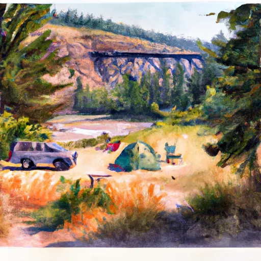
The campground amenities include picnic tables, fire rings, vault toilets, and potable water. The campsite is relatively small, with only 10 sites available on a first-come, first-served basis. The area is home to a variety of wildlife, including grizzly bears, black bears, elk, deer, and mountain lions, so visitors should take appropriate precautions while camping.
Interesting facts about the area include that the Sun River is a designated Wild and Scenic River, and it is home to a variety of fish species, including rainbow and brown trout. The Sun River Wildlife Management Area is also nearby, offering visitors the opportunity to view a variety of wildlife in their natural habitat.
The best time of year to visit the Lowry Bridge Campsite is from mid-June to mid-September when the temperatures are mild, and the weather is generally dry. Average temperatures during this time range from the mid-60s to the mid-80s Fahrenheit. However, visitors should be prepared for sudden weather changes and occasional thunderstorms.
Overall, the Lowry Bridge Campsite is an excellent destination for those seeking a peaceful camping experience in a beautiful natural setting. With its stunning views, nearby points of interest, and a variety of outdoor activities available, it is a must-visit location for any Montana camper.
What's on-site at Lowry Bridge
Key facilities Snoflo tracks for this campground. Confirm with the operator before booking -- amenities can change seasonally.
Plan your trip down to the hour
Same weather feed Snoflo's iOS app uses -- updated continuously from NOAA / yr.no.
Next 5 days, hour by hour
Temperature line with weather symbols on top, snow + rain accumulation as columns, humidity as a dotted line.
5-day forecast table
Every 3 hours, broken out across temperature, snow, rain, humidity, and wind. Each cell is colour-coded relative to the column min/max so trends jump out at a glance.
| Time | Condition | Temp (°F) | Snow (in) | Rain (in) | Humidity (%) | Wind (mps) | Wind dir |
|---|---|---|---|---|---|---|---|
| Loading detailed forecast… | |||||||
15-day temperature & precipitation
Daily temperatures, snow, and rain projected over the next two weeks. Hover any point for the full breakdown.
Other campgrounds in the area
Snoflo-tracked campsites within driving distance of Lowry Bridge, with reservations status.
| Campground | Reservations | Toilets | View |
|---|---|---|---|
| Lowry Camp Site | ✗ | ✗ | → |
| Fairfield City Park | ✗ | ✓ | → |
| Wagon's West | ✗ | ✗ | → |
| Willow Creek Fas | ✗ | ✓ | → |
| Red Sky Mobile Home & Rv Park | ✗ | ✗ | → |
Nearby streamflow
USGS streamgauges within reach of Lowry Bridge -- pulled live from the National Water Information System.
| Streamgauge | Discharge | View |
|---|---|---|
| Sun River At Simms Mt | 140 cfs | → |
| Sun River Bl Willow Cr Nr Augusta Mt | 247 cfs | → |
| Muddy Creek At Vaughn Mt | 300 cfs | → |
| Dearborn River Near Craig Mt | 116 cfs | → |
| Missouri River At Cascade Mt | 3,770 cfs | → |
| Sun River Near Vaughn Mt | 683 cfs | → |
Nearby snow depths
NRCS SNOTEL stations within reach of Lowry Bridge -- relevant when planning a shoulder-season or alpine trip.
| SNOTEL station | Snowpack | 24h Snowfall | View |
|---|---|---|---|
| Nohrsc Fairfield 6.0 Ese | 0.0 in | 0.0 in | → |
| Nohrsc Fairfield 5.6 Ne | 0.0 in | 0.0 in | → |
| Nohrsc Fairfield 5.0 Nne | 0.0 in | 0.0 in | → |
| Sun River Se | 0.0 in | 0.0 in | → |
| Choteau | 0.0 in | 0.0 in | → |
| Mt Mesonet Benton Lake | 0.0 in | 0.0 in | → |
Plan a longer trip
The closest parks, lakes, boat launches, and paddle runs so a camping night can grow into a full weekend.
Parks
- First Peoples Buffalo Jump State Park
- Tower Rock State Park
- Wadsworth Park
- Lewis And Clark National Forest
- Bloomingdale Park
- Noah's Ark Park
Boat launches
- Lowry Bridge
- North Fork Sun River Rec Site
- Willow Creek Reservoir
- Old Us Highway 91 Cascade County
- Pelican Point
- Nilan Reservoir
Fishing spots
Points of interest
- Teton Antique Tractor & Steam Engines
- First Peoples Buffalo Jump Sp
- Old Trail Museum
- Dearborn River High Bridge
- Earle E Heikka Museum
Paddle runs
- Headwaters, Sec. 13, T18n, R10w To Forest Boundary, Sec. 6, T17n, R7w
- Headwaters, Sec. 15, T18n, R10w To Straight Creek, Sec. 25, T19n, R10w
- Wilderness Boundary To South Fork Sun River, Sec. 26, T22n, R10w
- Headwaters, Sec. 4, T18n, R10w To North Fork Sun River, Sec. 26, T22n, R10w
- Fool Creek, Sec. 24, T25n, R11w To Wilderness Boundary
- Dobrota Headwaters, Sec. 23, T18n, R10w To Mainstem, Sec. 31, T18n, R9w
Camping essentials & Leave No Trace
- Pack it in, pack it out
- Take all trash, food scraps, and gear back with you to keep campsites clean and protect wildlife.
- Respect wildlife
- Observe animals from a distance, store food securely, and never feed wildlife to maintain natural behavior and safety.
- Know before you go
- Check weather, fire restrictions, trail conditions, and permit requirements to ensure a safe and well-planned trip.
- Minimize campfire impact
- Use established fire rings, keep fires small, fully extinguish them, or opt for a camp stove when fires are restricted.
- Leave what you find
- Preserve natural and cultural features by avoiding removal of plants, rocks, artifacts, or other elements of the environment.
Set push alerts in the Snoflo app
Save Lowry Bridge as a favorite, set a custom threshold (precipitation, snowpack, freezing temperatures), and the iOS app will push the moment conditions cross.
About Lowry Bridge
Can I make reservations at Lowry Bridge?
This campground does not appear to accept reservations -- it's typically first-come, first-served. Arrive early on summer weekends.
How fresh is the weather data on this page?
The hourly forecast updates throughout the day from the NOAA / yr.no public feeds. Streamflow data is pulled live from USGS streamgauges and snowpack from the NRCS SNOTEL network.
What's the best time of year to visit?
Use the 15-day temperature & precipitation outlook on this page to plan -- pick a window with comfortable temperatures and low precipitation. For longer trips, the 5-day hourly meteogram shows snow + rain accumulation hour-by-hour.
How do I get to Lowry Bridge?
Tap Directions in the hero above to open driving directions in Google Maps, or Open in map to center the Snoflo interactive map on the campground.
Can I get alerts when conditions change?
Yes -- alerts are managed through the Snoflo iOS app. Favorite this campground, set a threshold (temperature, snowpack, precipitation), and you'll get a push the moment it crosses.
Other campgrounds near here
Snoflo-tracked campgrounds within driving distance of Lowry Bridge.