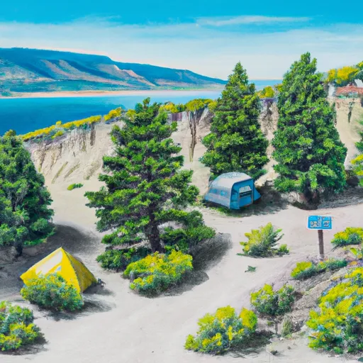
Pelican Point Fas Campground
Community Reviews
Been here? Share the conditions.
Reviews, ratings & photos are added in the free Snoflo iOS app — rate a spot, tag the conditions, and your visit is verified by location. Add or manage your reviews from the app.
Pelican Point Fas
Reservations are not accepted at Pelican Point Fas camping area, meaning it operates on a first-come, first-served basis. Therefore, it is recommended to arrive early, especially during peak seasons, to secure a campsite.
The best time to visit Pelican Point Fas camping area is during the summer months, typically from June to September, when the weather is pleasant and activities like fishing, boating, and hiking can be enjoyed to the fullest. It is advisable to check the weather conditions and prepare accordingly, as temperatures can vary in Montana.
While camping in Pelican Point Fas, campers should be cautious of wildlife encounters, especially bears. It is recommended to store food securely and follow proper bear safety protocols. Additionally, it is essential to be aware of fire restrictions and regulations in the area to prevent any unwanted incidents.
Overall, Pelican Point Fas camping area in Montana offers a beautiful natural setting for camping, with basic amenities and a peaceful environment. It is an ideal destination for those seeking a rustic camping experience surrounded by stunning landscapes.
What's on-site at Pelican Point Fas
Key facilities Snoflo tracks for this campground. Confirm with the operator before booking -- amenities can change seasonally.
Plan your trip down to the hour
Same weather feed Snoflo's iOS app uses -- updated continuously from NOAA / yr.no.
Next 5 days, hour by hour
Temperature line with weather symbols on top, snow + rain accumulation as columns, humidity as a dotted line.
5-day forecast table
Every 3 hours, broken out across temperature, snow, rain, humidity, and wind. Each cell is colour-coded relative to the column min/max so trends jump out at a glance.
| Time | Condition | Temp (°F) | Snow (in) | Rain (in) | Humidity (%) | Wind (mps) | Wind dir |
|---|---|---|---|---|---|---|---|
| Loading detailed forecast… | |||||||
15-day temperature & precipitation
Daily temperatures, snow, and rain projected over the next two weeks. Hover any point for the full breakdown.
Other campgrounds in the area
Snoflo-tracked campsites within driving distance of Pelican Point Fas, with reservations status.
| Campground | Reservations | Toilets | View |
|---|---|---|---|
| Prewett Creek Fas | ✗ | ✓ | → |
| Mountain Palace Fas | ✗ | ✗ | → |
| American Legion/Lions Park - Cascade | ✗ | ✗ | → |
| Mid Canon Fas | ✗ | ✓ | → |
| Dearborn Fas | ✗ | ✓ | → |
Nearby streamflow
USGS streamgauges within reach of Pelican Point Fas -- pulled live from the National Water Information System.
| Streamgauge | Discharge | View |
|---|---|---|
| Missouri River At Cascade Mt | 3,580 cfs | → |
| Dearborn River Near Craig Mt | 73 cfs | → |
| Missouri River Bl Holter Dam Nr Wolf Cr Mt | 3,490 cfs | → |
| Smith River Near Eden Mt | 123 cfs | → |
| Little Prickly Pear Cr At Wolf Cr Mt | 34 cfs | → |
| Sun River At Simms Mt | 95 cfs | → |
Nearby snow depths
NRCS SNOTEL stations within reach of Pelican Point Fas -- relevant when planning a shoulder-season or alpine trip.
| SNOTEL station | Snowpack | 24h Snowfall | View |
|---|---|---|---|
| Sun River Se | 0.0 in | 0.0 in | → |
| Great Falls Airport | 0.0 in | 0.0 in | → |
| Nohrsc Fairfield 6.0 Ese | 0.0 in | 0.0 in | → |
| Nohrsc Fairfield 5.6 Ne | 0.0 in | 0.0 in | → |
| Nohrsc Fairfield 5.0 Nne | 0.0 in | 0.0 in | → |
| Mt Mesonet Benton Lake | 0.0 in | 0.0 in | → |
Plan a longer trip
The closest parks, lakes, boat launches, and paddle runs so a camping night can grow into a full weekend.
Parks
- Tower Rock State Park
- Holter Lake Recreation Area
- First Peoples Buffalo Jump State Park
- Wilderness Gates Of The Mountains
- Grande Vista Park
- Wadsworth Park
Boat launches
Fishing spots
- Dearborn River
- Hound Creek
- Duck Creek
- Dry Creek-Krezelok Reservoir
- Little Prickly Pear Creek
- Rock Creek (Smith Drainage)
Points of interest
- First Peoples Buffalo Jump Sp
- Earle E Heikka Museum
- Dearborn River High Bridge
- A. Hooker's Gallery
- The History Museum
- Children's Museum Of Montana
Paddle runs
- Tenderfoot Creek, Sec. 30, T14n, R4e To Deep Creek, Sec. 31, T16n, R4e
- Falls, Sec. 25, T14n, R4e To Smith River, Sec. 25, T14n, R3e
- Missouri River
- Hauser Dam, Sec. 29, T12n, R2w To Cochran Gulch, Sec. 18, T12n, R2w
- Town Of Nelson, Sec. 12, T12n, R2w To Missouri River, Sec. 19, T12n, R2w
Camping essentials & Leave No Trace
- Pack it in, pack it out
- Take all trash, food scraps, and gear back with you to keep campsites clean and protect wildlife.
- Respect wildlife
- Observe animals from a distance, store food securely, and never feed wildlife to maintain natural behavior and safety.
- Know before you go
- Check weather, fire restrictions, trail conditions, and permit requirements to ensure a safe and well-planned trip.
- Minimize campfire impact
- Use established fire rings, keep fires small, fully extinguish them, or opt for a camp stove when fires are restricted.
- Leave what you find
- Preserve natural and cultural features by avoiding removal of plants, rocks, artifacts, or other elements of the environment.
Set push alerts in the Snoflo app
Save Pelican Point Fas as a favorite, set a custom threshold (precipitation, snowpack, freezing temperatures), and the iOS app will push the moment conditions cross.
About Pelican Point Fas
Can I make reservations at Pelican Point Fas?
This campground does not appear to accept reservations -- it's typically first-come, first-served. Arrive early on summer weekends.
How fresh is the weather data on this page?
The hourly forecast updates throughout the day from the NOAA / yr.no public feeds. Streamflow data is pulled live from USGS streamgauges and snowpack from the NRCS SNOTEL network.
What's the best time of year to visit?
Use the 15-day temperature & precipitation outlook on this page to plan -- pick a window with comfortable temperatures and low precipitation. For longer trips, the 5-day hourly meteogram shows snow + rain accumulation hour-by-hour.
How do I get to Pelican Point Fas?
Tap Directions in the hero above to open driving directions in Google Maps, or Open in map to center the Snoflo interactive map on the campground.
Can I get alerts when conditions change?
Yes -- alerts are managed through the Snoflo iOS app. Favorite this campground, set a threshold (temperature, snowpack, precipitation), and you'll get a push the moment it crosses.
Other campgrounds near here
Snoflo-tracked campgrounds within driving distance of Pelican Point Fas.