Island Park - Pine Flat Lake campground
Community Reviews
Been here? Share the conditions.
Reviews, ratings & photos are added in the free Snoflo iOS app — rate a spot, tag the conditions, and your visit is verified by location. Add or manage your reviews from the app.
Island Park - Pine Flat Lake
Reservations are accepted at Island Park - Pine Flat Lake camping area, ensuring a hassle-free experience for campers. It is advisable to make a reservation in advance, especially during peak season, to secure a spot. The best time to visit this camping area is in the spring and fall when the weather is mild, and the crowds are smaller. During these seasons, you can enjoy the beautiful scenery and engage in outdoor activities without the sweltering heat or heavy tourist traffic.
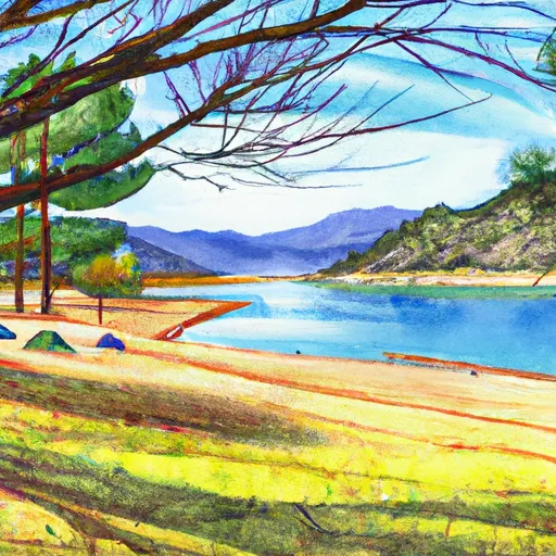
It is worth noting that the campground is known for its stunning views of Pine Flat Lake, surrounded by lush forests and rolling hills. Visitors can explore the nearby hiking trails, which offer opportunities for birdwatching and wildlife spotting. However, campers should be cautious of wildlife encounters and follow safety guidelines to ensure a pleasant camping experience.
What's on-site at Island Park - Pine Flat Lake
Key facilities Snoflo tracks for this campground. Confirm with the operator before booking -- amenities can change seasonally.
Plan your trip down to the hour
Same weather feed Snoflo's iOS app uses -- updated continuously from NOAA / yr.no.
Next 5 days, hour by hour
Temperature line with weather symbols on top, snow + rain accumulation as columns, humidity as a dotted line.
5-day forecast table
Every 3 hours, broken out across temperature, snow, rain, humidity, and wind. Each cell is colour-coded relative to the column min/max so trends jump out at a glance.
| Time | Condition | Temp (°F) | Snow (in) | Rain (in) | Humidity (%) | Wind (mps) | Wind dir |
|---|---|---|---|---|---|---|---|
| Loading detailed forecast… | |||||||
15-day temperature & precipitation
Daily temperatures, snow, and rain projected over the next two weeks. Hover any point for the full breakdown.
Other campgrounds in the area
Snoflo-tracked campsites within driving distance of Island Park - Pine Flat Lake, with reservations status.
| Campground | Reservations | Toilets | View |
|---|---|---|---|
| Island Park Group Site | ✗ | ✗ | → |
| Pine Flat Rec Area | ✗ | ✓ | → |
| Trimmer - Pine Flat Lake | ✓ | ✓ | → |
| Trimmer Campground | ✗ | ✗ | → |
| Choinumni | ✗ | ✓ | → |
Nearby streamflow
USGS streamgauges within reach of Island Park - Pine Flat Lake -- pulled live from the National Water Information System.
| Streamgauge | Discharge | View |
|---|---|---|
| San Joaquin R Bl Friant Ca | 349 cfs | → |
| Marble Fork Kaweah R Ab Horse C Nr Lodgepole Ca | 52 cfs | → |
| Nf Willow C Nr Sugar Pine Ca | 416 cfs | → |
| Big C Div Nr Fish Camp Ca | 0 cfs | → |
| Mf San Joaquin R Nr Mammoth Lakes Ca | 321 cfs | → |
| San Joaquin R Nr Mendota Ca | 149 cfs | → |
Nearby snow depths
NRCS SNOTEL stations within reach of Island Park - Pine Flat Lake -- relevant when planning a shoulder-season or alpine trip.
| SNOTEL station | Snowpack | 24h Snowfall | View |
|---|---|---|---|
| Nohrsc Tamarack Summit | 0.4 in | 0.0 in | → |
| Huntington Lake | 1.5 in | 0.0 in | → |
| Upper Burnt Corral Meadow | 0.0 in | 0.0 in | → |
| Nohrsc Kaiser Point | 175.7 in | 0.0 in | → |
| Blackcap Basin Goes | 0.0 in | 0.0 in | → |
| Nohrsc Chilkoot Meadow | 0.2 in | 0.0 in | → |
Plan a longer trip
The closest parks, lakes, boat launches, and paddle runs so a camping night can grow into a full weekend.
Parks
- Faller Park
- Sanger Park
- Jenni Park
- Big Table Mountain Ecological Reserve
- Citizens Park
- Westcal Iii Park
Boat launches
- Sunnyslope Road 30796, Sanger
- North Piedra Road 3140, Sanger
- Redinger Boating Site
- San Joaquin River Trail, Friant
- Sandy Cove Road Fresno County
- Hume Lake Boat Launch (East Dam)
Fishing spots
- Pine Flat Lake
- Kings River, Below Pine Flat Reservoir
- Avocado Lake
- Dinkey Meadow Creek
- Shaver Lake
- Hatch Lake
Points of interest
- Delilah Lookout
- Dunlap Vista
- Blue Canyon Vista Observation Site
- Converse Basin Grove
- Boole Tree
- Mcgee Overlook
Paddle runs
- Blarney Meadows To South End Of Florence Lake
- Hot Springs Area To West End Of Blarney River
- Northwest Boundary Of Nf/Kings Canyon Np To Hot Springs Area
- Outlet Of Martha Lake (Boundary Extend 0.25 Mile On Each Side Of River) To Northwestern Boundary Of Kings Canyon National Park
- Confluence With North Fork San Joaquin River To Hells Half Acre
- Wilderness Boundary Just Below Tokopah Falls (Boundary Extend 0.25 Mile On Each Side Of River) To Confluence With The Middle Fork Kaweah River
Camping essentials & Leave No Trace
- Pack it in, pack it out
- Take all trash, food scraps, and gear back with you to keep campsites clean and protect wildlife.
- Respect wildlife
- Observe animals from a distance, store food securely, and never feed wildlife to maintain natural behavior and safety.
- Know before you go
- Check weather, fire restrictions, trail conditions, and permit requirements to ensure a safe and well-planned trip.
- Minimize campfire impact
- Use established fire rings, keep fires small, fully extinguish them, or opt for a camp stove when fires are restricted.
- Leave what you find
- Preserve natural and cultural features by avoiding removal of plants, rocks, artifacts, or other elements of the environment.
Set push alerts in the Snoflo app
Save Island Park - Pine Flat Lake as a favorite, set a custom threshold (precipitation, snowpack, freezing temperatures), and the iOS app will push the moment conditions cross.
About Island Park - Pine Flat Lake
Can I make reservations at Island Park - Pine Flat Lake?
Yes -- this campground accepts reservations. Snoflo recommends booking early for peak season; check the operator (Recreation.gov / state park system / private operator) for the booking window and cancellation policy.
How fresh is the weather data on this page?
The hourly forecast updates throughout the day from the NOAA / yr.no public feeds. Streamflow data is pulled live from USGS streamgauges and snowpack from the NRCS SNOTEL network.
What's the best time of year to visit?
Use the 15-day temperature & precipitation outlook on this page to plan -- pick a window with comfortable temperatures and low precipitation. For longer trips, the 5-day hourly meteogram shows snow + rain accumulation hour-by-hour.
How do I get to Island Park - Pine Flat Lake?
Tap Directions in the hero above to open driving directions in Google Maps, or Open in map to center the Snoflo interactive map on the campground.
Can I get alerts when conditions change?
Yes -- alerts are managed through the Snoflo iOS app. Favorite this campground, set a threshold (temperature, snowpack, precipitation), and you'll get a push the moment it crosses.
Other campgrounds near here
Snoflo-tracked campgrounds within driving distance of Island Park - Pine Flat Lake.