Oconee Point - Hartwell Lake Campground
Community Reviews
Been here? Share the conditions.
Reviews, ratings & photos are added in the free Snoflo iOS app — rate a spot, tag the conditions, and your visit is verified by location. Add or manage your reviews from the app.
Oconee Point - Hartwell Lake
Reservations are accepted at Oconee Point, ensuring campers have a guaranteed spot during their visit. It is advisable to make reservations in advance, especially during peak seasons, to secure a desirable campsite.
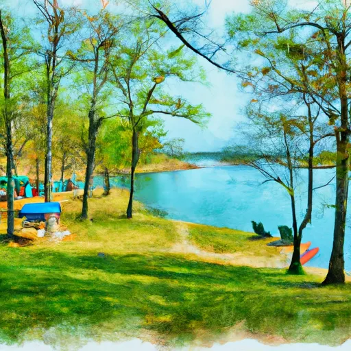
The best time of year to visit Oconee Point is during the spring and fall seasons when the weather is pleasant for outdoor activities. The campground offers beautiful views of the lake and surrounding natural scenery, making it a perfect destination for nature enthusiasts and photographers.
While camping at Oconee Point, it is essential to be cautious of wildlife, such as snakes and insects, that are common in the area. Campers should also be mindful of the rules and regulations regarding campfires and fishing in order to have a safe and enjoyable experience. With its scenic beauty, modern facilities, and a variety of recreational opportunities, Oconee Point is a fantastic camping destination for those looking to connect with nature in South Carolina.
What's on-site at Oconee Point - Hartwell Lake
Key facilities Snoflo tracks for this campground. Confirm with the operator before booking -- amenities can change seasonally.
Plan your trip down to the hour
Same weather feed Snoflo's iOS app uses -- updated continuously from NOAA / yr.no.
Next 5 days, hour by hour
Temperature line with weather symbols on top, snow + rain accumulation as columns, humidity as a dotted line.
5-day forecast table
Every 3 hours, broken out across temperature, snow, rain, humidity, and wind. Each cell is colour-coded relative to the column min/max so trends jump out at a glance.
| Time | Condition | Temp (°F) | Snow (in) | Rain (in) | Humidity (%) | Wind (mps) | Wind dir |
|---|---|---|---|---|---|---|---|
| Loading detailed forecast… | |||||||
15-day temperature & precipitation
Daily temperatures, snow, and rain projected over the next two weeks. Hover any point for the full breakdown.
Other campgrounds in the area
Snoflo-tracked campsites within driving distance of Oconee Point - Hartwell Lake, with reservations status.
| Campground | Reservations | Toilets | View |
|---|---|---|---|
| Coneross - Hartwell Lake | ✓ | ✗ | → |
| Twin Lakes - Hartwell Lake | ✓ | ✗ | → |
| South Cove | ✗ | ✗ | → |
| South Cove County Park | ✗ | ✗ | → |
| Anderson Area Day Camp | ✗ | ✗ | → |
Nearby streamflow
USGS streamgauges within reach of Oconee Point - Hartwell Lake -- pulled live from the National Water Information System.
| Streamgauge | Discharge | View |
|---|---|---|
| Twelvemile Creek Near Liberty | 37 cfs | → |
| Rocky River Nr Starr | 33 cfs | → |
| Saluda River Near Williamston | 349 cfs | → |
| Saluda River Near Greenville | 285 cfs | → |
| Chattooga River Near Clayton | 215 cfs | → |
| Beaverdam Creek Ab Elberton Ga | 32 cfs | → |
Nearby snow depths
NRCS SNOTEL stations within reach of Oconee Point - Hartwell Lake -- relevant when planning a shoulder-season or alpine trip.
| SNOTEL station | Snowpack | 24h Snowfall | View |
|---|---|---|---|
| Anderson | 0.0 in | 0.0 in | → |
| Antreville | 0.0 in | 0.0 in | → |
| Carnesville 7.3 Sw | 0.0 in | 0.0 in | → |
| Cleveland 3 S | 0.0 in | 0.0 in | → |
| Fountain Inn 2 Sw | 0.0 in | 0.0 in | → |
| Germany Valley | 0.0 in | 0.0 in | → |
Plan a longer trip
The closest parks, lakes, boat launches, and paddle runs so a camping night can grow into a full weekend.
Parks
- South Carolina Botanical Gardens
- Blue Ridge Field
- Earl Anderson Park
- South Cove County Park
- Anderson Sports And Entertainment Center
- Tugaloo State Park
Boat launches
Fishing spots
Points of interest
- Howard's Rock
- Clemson Area African American Museum
- M60
- Old Pickens Presbyterian Church
- Rosehill Museum
Paddle runs
- Confluence Of Cedar Creek To 1/4 Mile Below The Nf Boundary And Fh 110, Cobbs Bridge Road
- South Of Cedar Creek Rifle Range To Confluence With Chauga River
- 1/4 Mile Below Fs 745 And Cassidy Bridge Hunt Camp To Confluence Of Cedar Creek
- Crpssing Of Land Bridge Road, Sc 196 To 1/4 Mile Below Fs 745 And Cassidy Bridge Hunt Camp
- Headwaters Just East Of Hwy 107 To Crossing Of Norton Field Road (Fs 715a)
- Beginning Just Upstream Of Townes Creek,Wash Branch And Crane Creek To Confluence With Kings Creek
Camping essentials & Leave No Trace
- Pack it in, pack it out
- Take all trash, food scraps, and gear back with you to keep campsites clean and protect wildlife.
- Respect wildlife
- Observe animals from a distance, store food securely, and never feed wildlife to maintain natural behavior and safety.
- Know before you go
- Check weather, fire restrictions, trail conditions, and permit requirements to ensure a safe and well-planned trip.
- Minimize campfire impact
- Use established fire rings, keep fires small, fully extinguish them, or opt for a camp stove when fires are restricted.
- Leave what you find
- Preserve natural and cultural features by avoiding removal of plants, rocks, artifacts, or other elements of the environment.
Set push alerts in the Snoflo app
Save Oconee Point - Hartwell Lake as a favorite, set a custom threshold (precipitation, snowpack, freezing temperatures), and the iOS app will push the moment conditions cross.
About Oconee Point - Hartwell Lake
Can I make reservations at Oconee Point - Hartwell Lake?
Yes -- this campground accepts reservations. Snoflo recommends booking early for peak season; check the operator (Recreation.gov / state park system / private operator) for the booking window and cancellation policy.
How fresh is the weather data on this page?
The hourly forecast updates throughout the day from the NOAA / yr.no public feeds. Streamflow data is pulled live from USGS streamgauges and snowpack from the NRCS SNOTEL network.
What's the best time of year to visit?
Use the 15-day temperature & precipitation outlook on this page to plan -- pick a window with comfortable temperatures and low precipitation. For longer trips, the 5-day hourly meteogram shows snow + rain accumulation hour-by-hour.
How do I get to Oconee Point - Hartwell Lake?
Tap Directions in the hero above to open driving directions in Google Maps, or Open in map to center the Snoflo interactive map on the campground.
Can I get alerts when conditions change?
Yes -- alerts are managed through the Snoflo iOS app. Favorite this campground, set a threshold (temperature, snowpack, precipitation), and you'll get a push the moment it crosses.
Other campgrounds near here
Snoflo-tracked campgrounds within driving distance of Oconee Point - Hartwell Lake.