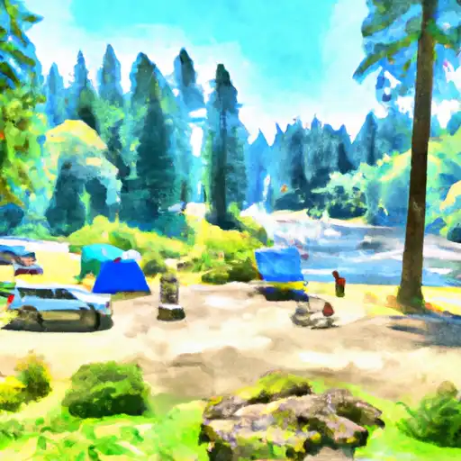
South Umpqua Falls Campground
Community Reviews
Been here? Share the conditions.
Reviews, ratings & photos are added in the free Snoflo iOS app — rate a spot, tag the conditions, and your visit is verified by location. Add or manage your reviews from the app.
South Umpqua Falls
Reservations are not required at South Umpqua Falls camping area. The campground operates on a first-come, first-served basis, allowing campers to choose their preferred spot upon arrival. However, it is recommended to arrive early, especially during peak seasons, to secure a good camping spot.
The best time of year to visit South Umpqua Falls camping area is during the summer months when the weather is pleasant and conducive to outdoor activities. It is important to note that the campground is not accessible during winter due to heavy snowfall, so it is advisable to plan your visit accordingly.
South Umpqua Falls, the main attraction of the camping area, is a stunning waterfall that cascades down rocky cliffs, creating a mesmerizing sight. Visitors can indulge in various recreational activities such as hiking, fishing, and swimming in the refreshing waters of the falls. However, it is crucial to exercise caution while swimming as the water currents can be strong and unpredictable. Additionally, be mindful of wildlife, respect the natural surroundings, and always practice proper campfire safety measures to ensure an enjoyable and safe camping experience at South Umpqua Falls camping area.
What's on-site at South Umpqua Falls
Key facilities Snoflo tracks for this campground. Confirm with the operator before booking -- amenities can change seasonally.
Plan your trip down to the hour
Same weather feed Snoflo's iOS app uses -- updated continuously from NOAA / yr.no.
Next 5 days, hour by hour
Temperature line with weather symbols on top, snow + rain accumulation as columns, humidity as a dotted line.
5-day forecast table
Every 3 hours, broken out across temperature, snow, rain, humidity, and wind. Each cell is colour-coded relative to the column min/max so trends jump out at a glance.
| Time | Condition | Temp (°F) | Snow (in) | Rain (in) | Humidity (%) | Wind (mps) | Wind dir |
|---|---|---|---|---|---|---|---|
| Loading detailed forecast… | |||||||
15-day temperature & precipitation
Daily temperatures, snow, and rain projected over the next two weeks. Hover any point for the full breakdown.
Other campgrounds in the area
Snoflo-tracked campsites within driving distance of South Umpqua Falls, with reservations status.
| Campground | Reservations | Toilets | View |
|---|---|---|---|
| South Umpqua Falls Campground | ✓ | ✗ | → |
| South Umpqua Falls Group | ✗ | ✗ | → |
| Ash Flat Forest Camp | ✗ | ✓ | → |
| Ash Flat Campground | ✓ | ✗ | → |
| Skillet Creek Forest Camp | ✗ | ✗ | → |
Nearby streamflow
USGS streamgauges within reach of South Umpqua Falls -- pulled live from the National Water Information System.
| Streamgauge | Discharge | View |
|---|---|---|
| South Umpqua River At Tiller | 38 cfs | → |
| Elk Creek Nr Drew | 1 cfs | → |
| Fish Creek Abv Slipper Creek Nr Toketee Falls | 36 cfs | → |
| N Umpqua River Abv Copeland Ck Nr Toketee Falls | 678 cfs | → |
| Boulder Creek Near Toketee Falls | 5 cfs | → |
| N.Umpqua R Blw Slide Ck Dam Nr Toketee Falls | 265 cfs | → |
Nearby snow depths
NRCS SNOTEL stations within reach of South Umpqua Falls -- relevant when planning a shoulder-season or alpine trip.
| SNOTEL station | Snowpack | 24h Snowfall | View |
|---|---|---|---|
| Nohrsc Toketee Airstrip | 0.0 in | 0.0 in | → |
| Toketee Airstrip | 0.0 in | 0.0 in | → |
| Nohrsc Diamond Lake | 0.0 in | 0.0 in | → |
| Annie Springs | 0.0 in | 0.0 in | → |
| Annie Springs | 0.0 in | 0.0 in | → |
| Diamond Lake | 0.0 in | 0.0 in | → |
Plan a longer trip
The closest parks, lakes, boat launches, and paddle runs so a camping night can grow into a full weekend.
Parks
- Wilderness Rogue-Umpqua Divide
- Wilderness Boulder Creek
- Andrew Wiley Park
- Prospect State Scenic Viewpoint
- North Myrtle Park
- Joseph H Stewart State Recreation Area
Boat launches
Points of interest
- World's Tallest Sugarpine
- Whaleback Snow-Survey Cabin
- Union Creek Amphitheatre
- Natural Bridge
- Susan Creek Campground
- Milo Drive
Paddle runs
- Headwaters To Confluence Of Foster Creek
- South Umpqua
- Crater Lake Np Boundary To Confluence With Rogue River
- Headwaters To Rogue-Umpqua Wilderness Boundary
- Rogue-Umpqua Wilderness Boundary To Confluence With North Fork Rogue River
- Headwaters To Boulder Creek Wilderness Boundary
Camping essentials & Leave No Trace
- Pack it in, pack it out
- Take all trash, food scraps, and gear back with you to keep campsites clean and protect wildlife.
- Respect wildlife
- Observe animals from a distance, store food securely, and never feed wildlife to maintain natural behavior and safety.
- Know before you go
- Check weather, fire restrictions, trail conditions, and permit requirements to ensure a safe and well-planned trip.
- Minimize campfire impact
- Use established fire rings, keep fires small, fully extinguish them, or opt for a camp stove when fires are restricted.
- Leave what you find
- Preserve natural and cultural features by avoiding removal of plants, rocks, artifacts, or other elements of the environment.
Set push alerts in the Snoflo app
Save South Umpqua Falls as a favorite, set a custom threshold (precipitation, snowpack, freezing temperatures), and the iOS app will push the moment conditions cross.
About South Umpqua Falls
Can I make reservations at South Umpqua Falls?
This campground does not appear to accept reservations -- it's typically first-come, first-served. Arrive early on summer weekends.
How fresh is the weather data on this page?
The hourly forecast updates throughout the day from the NOAA / yr.no public feeds. Streamflow data is pulled live from USGS streamgauges and snowpack from the NRCS SNOTEL network.
What's the best time of year to visit?
Use the 15-day temperature & precipitation outlook on this page to plan -- pick a window with comfortable temperatures and low precipitation. For longer trips, the 5-day hourly meteogram shows snow + rain accumulation hour-by-hour.
How do I get to South Umpqua Falls?
Tap Directions in the hero above to open driving directions in Google Maps, or Open in map to center the Snoflo interactive map on the campground.
Can I get alerts when conditions change?
Yes -- alerts are managed through the Snoflo iOS app. Favorite this campground, set a threshold (temperature, snowpack, precipitation), and you'll get a push the moment it crosses.
Other campgrounds near here
Snoflo-tracked campgrounds within driving distance of South Umpqua Falls.