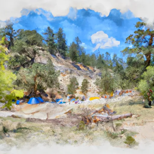
Tie Creek campground
Community Reviews
Been here? Share the conditions.
Reviews, ratings & photos are added in the free Snoflo iOS app — rate a spot, tag the conditions, and your visit is verified by location. Add or manage your reviews from the app.
Tie Creek
The campground amenities include picnic tables, fire rings, and vault toilets. There is also potable water available, but no hookups or showers. The camping area is first-come-first-serve, and there are 16 campsites available. One quirky fact about the area is that it was used as a filming location for the 1994 movie "The River Wild," starring Meryl Streep and Kevin Bacon.
The best time of year to visit Tie Creek Camping Area is during the summer months of June through August. The average temperatures during this time range from 75-85 degrees Fahrenheit during the day to 45-55 degrees Fahrenheit at night. Visitors should note that the campground is at a high elevation and can experience cooler temperatures even during the summer. Overall, Tie Creek Camping Area is a beautiful and peaceful spot for camping and outdoor recreation.
What's on-site at Tie Creek
Key facilities Snoflo tracks for this campground. Confirm with the operator before booking -- amenities can change seasonally.
Plan your trip down to the hour
Same weather feed Snoflo's iOS app uses -- updated continuously from NOAA / yr.no.
Next 5 days, hour by hour
Temperature line with weather symbols on top, snow + rain accumulation as columns, humidity as a dotted line.
5-day forecast table
Every 3 hours, broken out across temperature, snow, rain, humidity, and wind. Each cell is colour-coded relative to the column min/max so trends jump out at a glance.
| Time | Condition | Temp (°F) | Snow (in) | Rain (in) | Humidity (%) | Wind (mps) | Wind dir |
|---|---|---|---|---|---|---|---|
| Loading detailed forecast… | |||||||
15-day temperature & precipitation
Daily temperatures, snow, and rain projected over the next two weeks. Hover any point for the full breakdown.
Other campgrounds in the area
Snoflo-tracked campsites within driving distance of Tie Creek, with reservations status.
| Campground | Reservations | Toilets | View |
|---|---|---|---|
| Tie Creek Campground | ✗ | ✗ | → |
| Hardscrabble Campground | ✗ | ✗ | → |
| Hardscrabble | ✗ | ✓ | → |
| Rattlesnake Campground And Group Sites - Reserve | ✓ | ✗ | → |
| Rattlesnake | ✓ | ✓ | → |
Nearby streamflow
USGS streamgauges within reach of Tie Creek -- pulled live from the National Water Information System.
| Streamgauge | Discharge | View |
|---|---|---|
| Middle Fork Payette River Nr Crouch Id | 210 cfs | → |
| Nf Payette River Nr Banks Id | 1,850 cfs | → |
| Deadwood River Bl Deadwood Res Nr Lowman Id | 302 cfs | → |
| Sf Payette River At Lowman Id | 853 cfs | → |
| Payette River Nr Horseshoe Bend Id | 3,440 cfs | → |
| Payette River Nr Emmett Id | 2,120 cfs | → |
Nearby snow depths
NRCS SNOTEL stations within reach of Tie Creek -- relevant when planning a shoulder-season or alpine trip.
| SNOTEL station | Snowpack | 24h Snowfall | View |
|---|---|---|---|
| Nohrsc Cozy Cove | 2.0 in | 0.0 in | → |
| Cozy Cove | 0.0 in | 0.0 in | → |
| Mores Creek Summit | 0.0 in | 0.0 in | → |
| Mores Creek Summit | 0.0 in | 0.0 in | → |
| Van Wyck | 0.0 in | 0.0 in | → |
| Van Wyck | 0.0 in | 0.0 in | → |
Plan a longer trip
The closest parks, lakes, boat launches, and paddle runs so a camping night can grow into a full weekend.
Parks
Boat launches
- Confluence
- Deer Creek
- Cougar Mountain
- Banks River Access
- Cabarton Road Valley County
- Sage Hen Creek Boat Ramp
Fishing spots
Paddle runs
- Confluence With Bell Creek To Boiling Springs Cabin
- South Fork Payette
- Long Gulch To Boise Nf Boundary
- Boiling Springs Cabin To Confluence With Fool Creek
- Boise Nf Boundary To Confluence With Payette River
- Boise Nf Boundary (1 Mile East Of Banks) To Boise Nf Boundary (1 Mile South Of Banks)
Camping essentials & Leave No Trace
- Pack it in, pack it out
- Take all trash, food scraps, and gear back with you to keep campsites clean and protect wildlife.
- Respect wildlife
- Observe animals from a distance, store food securely, and never feed wildlife to maintain natural behavior and safety.
- Know before you go
- Check weather, fire restrictions, trail conditions, and permit requirements to ensure a safe and well-planned trip.
- Minimize campfire impact
- Use established fire rings, keep fires small, fully extinguish them, or opt for a camp stove when fires are restricted.
- Leave what you find
- Preserve natural and cultural features by avoiding removal of plants, rocks, artifacts, or other elements of the environment.
Set push alerts in the Snoflo app
Save Tie Creek as a favorite, set a custom threshold (precipitation, snowpack, freezing temperatures), and the iOS app will push the moment conditions cross.
About Tie Creek
Can I make reservations at Tie Creek?
This campground does not appear to accept reservations -- it's typically first-come, first-served. Arrive early on summer weekends.
How fresh is the weather data on this page?
The hourly forecast updates throughout the day from the NOAA / yr.no public feeds. Streamflow data is pulled live from USGS streamgauges and snowpack from the NRCS SNOTEL network.
What's the best time of year to visit?
Use the 15-day temperature & precipitation outlook on this page to plan -- pick a window with comfortable temperatures and low precipitation. For longer trips, the 5-day hourly meteogram shows snow + rain accumulation hour-by-hour.
How do I get to Tie Creek?
Tap Directions in the hero above to open driving directions in Google Maps, or Open in map to center the Snoflo interactive map on the campground.
Can I get alerts when conditions change?
Yes -- alerts are managed through the Snoflo iOS app. Favorite this campground, set a threshold (temperature, snowpack, precipitation), and you'll get a push the moment it crosses.
Other campgrounds near here
Snoflo-tracked campgrounds within driving distance of Tie Creek.