Dam Creek Walk-In Campground And Picnic Area Campground
Community Reviews
Been here? Share the conditions.
Reviews, ratings & photos are added in the free Snoflo iOS app — rate a spot, tag the conditions, and your visit is verified by location. Add or manage your reviews from the app.
Dam Creek Walk-In Campground And Picnic Area
Reservations are not accepted at Dam Creek Walk-In Campground And Picnic Area, so it operates on a first-come, first-served basis. It is advisable to arrive early, especially during peak seasons, to secure a camping spot. The best time of year to visit this campground is during the warmer months, from spring to early fall when the weather is pleasant for outdoor activities.
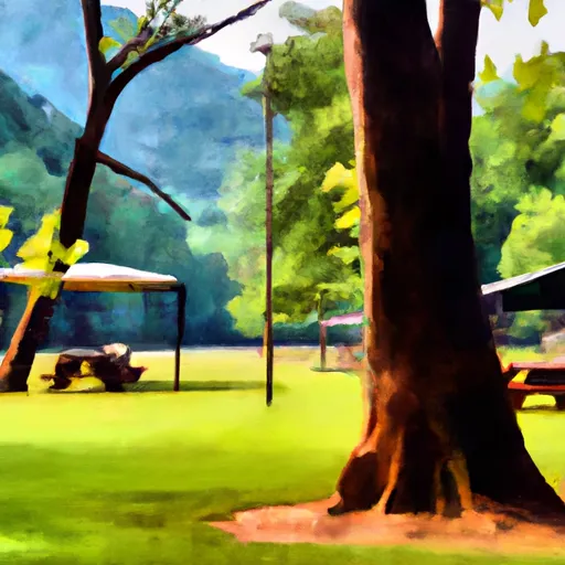
Aside from the amenities provided, Dam Creek Walk-In Campground And Picnic Area offers beautiful surroundings and picturesque views, making it a great spot for nature enthusiasts. The campground is situated near a creek, providing campers with the opportunity to enjoy fishing and relaxing by the water. However, caution must be exercised when camping here as there are reports of bears in the area. Campers are advised to properly store their food and dispose of waste in designated bear-proof containers to ensure their safety and the preservation of the natural habitat.
What's on-site at Dam Creek Walk-In Campground And Picnic Area
Key facilities Snoflo tracks for this campground. Confirm with the operator before booking -- amenities can change seasonally.
Plan your trip down to the hour
Same weather feed Snoflo's iOS app uses -- updated continuously from NOAA / yr.no.
Next 5 days, hour by hour
Temperature line with weather symbols on top, snow + rain accumulation as columns, humidity as a dotted line.
5-day forecast table
Every 3 hours, broken out across temperature, snow, rain, humidity, and wind. Each cell is colour-coded relative to the column min/max so trends jump out at a glance.
| Time | Condition | Temp (°F) | Snow (in) | Rain (in) | Humidity (%) | Wind (mps) | Wind dir |
|---|---|---|---|---|---|---|---|
| Loading detailed forecast… | |||||||
15-day temperature & precipitation
Daily temperatures, snow, and rain projected over the next two weeks. Hover any point for the full breakdown.
Other campgrounds in the area
Snoflo-tracked campsites within driving distance of Dam Creek Walk-In Campground And Picnic Area, with reservations status.
| Campground | Reservations | Toilets | View |
|---|---|---|---|
| Dam Creek | ✗ | ✗ | → |
| Spivey Cove Campground | ✗ | ✗ | → |
| Spivey Cove | ✗ | ✗ | → |
| North River Composite | ✗ | ✗ | → |
| Mcnabb Group Camp | ✓ | ✗ | → |
Nearby streamflow
USGS streamgauges within reach of Dam Creek Walk-In Campground And Picnic Area -- pulled live from the National Water Information System.
| Streamgauge | Discharge | View |
|---|---|---|
| Tellico River At Tellico Plains | 177 cfs | → |
| Valley River At Tomotla | 162 cfs | → |
| Cheoah River Nr Bearpen Gap Nr Tapoco | 128 cfs | → |
| Ocoee River At Copperhill | 498 cfs | → |
| Nantahala River Near Rainbow Springs | 171 cfs | → |
| Oostanaula Creek Near Sanford | 28 cfs | → |
Nearby snow depths
NRCS SNOTEL stations within reach of Dam Creek Walk-In Campground And Picnic Area -- relevant when planning a shoulder-season or alpine trip.
| SNOTEL station | Snowpack | 24h Snowfall | View |
|---|---|---|---|
| Bryson City 4 | 0.0 in | 0.0 in | → |
| Gatlinburg | 0.0 in | 0.0 in | → |
| New Found Gap | 14.9 in | 0.0 in | → |
| Kingston | 0.0 in | 0.0 in | → |
| Germany Valley | 0.0 in | 0.0 in | → |
| Dillard 0.7 Nnw | 0.0 in | 0.0 in | → |
Plan a longer trip
The closest parks, lakes, boat launches, and paddle runs so a camping night can grow into a full weekend.
Parks
- Wilderness Bald River Gorge
- Wilderness Citico Creek
- Wilderness Joyce Kilmer-Slickrock
- National Conservation Area Tellico Lake - Chota Unit
- Fort Loudoun State Recreation Area
- Great Smoky Mountains National Park
Boat launches
- Indian Boundary Boat Ramp Monroe County
- Hiwassee Dam Access Road 4692, Murphy
- Joe Brown Highway 8240, Murphy
- Joyce Kilmer Road 1920, Robbinsville
- Fairview Road 2418, Madisonville
- Micken Branch Cherokee County
Fishing spots
Points of interest
- Bald River Falls
- Joyce Kilmer Memorial Forest
- All Nations Cross
- Fields Of The Wood
- Lazy Timbers
- Golgotha Hill
Paddle runs
- Headwaters Near Graham County Line To Nc/Tn State Line
- Tn/Nc State Line (Rm 48.0) To Tn360 Bridge (Rm 30.0)
- Headwaters Near Mitchell Lick To Owlcamp Branch
- Owlcamp Branch To Polecat Branch
- Polecat Branch To Snowbird Picnic Area
- Apalachia Powerhouse (Rm 53.5) To Us411 Bridge (Rm 43.0)
Camping essentials & Leave No Trace
- Pack it in, pack it out
- Take all trash, food scraps, and gear back with you to keep campsites clean and protect wildlife.
- Respect wildlife
- Observe animals from a distance, store food securely, and never feed wildlife to maintain natural behavior and safety.
- Know before you go
- Check weather, fire restrictions, trail conditions, and permit requirements to ensure a safe and well-planned trip.
- Minimize campfire impact
- Use established fire rings, keep fires small, fully extinguish them, or opt for a camp stove when fires are restricted.
- Leave what you find
- Preserve natural and cultural features by avoiding removal of plants, rocks, artifacts, or other elements of the environment.
Set push alerts in the Snoflo app
Save Dam Creek Walk-In Campground And Picnic Area as a favorite, set a custom threshold (precipitation, snowpack, freezing temperatures), and the iOS app will push the moment conditions cross.
About Dam Creek Walk-In Campground And Picnic Area
Can I make reservations at Dam Creek Walk-In Campground And Picnic Area?
This campground does not appear to accept reservations -- it's typically first-come, first-served. Arrive early on summer weekends.
How fresh is the weather data on this page?
The hourly forecast updates throughout the day from the NOAA / yr.no public feeds. Streamflow data is pulled live from USGS streamgauges and snowpack from the NRCS SNOTEL network.
What's the best time of year to visit?
Use the 15-day temperature & precipitation outlook on this page to plan -- pick a window with comfortable temperatures and low precipitation. For longer trips, the 5-day hourly meteogram shows snow + rain accumulation hour-by-hour.
How do I get to Dam Creek Walk-In Campground And Picnic Area?
Tap Directions in the hero above to open driving directions in Google Maps, or Open in map to center the Snoflo interactive map on the campground.
Can I get alerts when conditions change?
Yes -- alerts are managed through the Snoflo iOS app. Favorite this campground, set a threshold (temperature, snowpack, precipitation), and you'll get a push the moment it crosses.
Other campgrounds near here
Snoflo-tracked campgrounds within driving distance of Dam Creek Walk-In Campground And Picnic Area.