Washington Creek Campground Campground
Community Reviews
Been here? Share the conditions.
Reviews, ratings & photos are added in the free Snoflo iOS app — rate a spot, tag the conditions, and your visit is verified by location. Add or manage your reviews from the app.
Washington Creek Campground
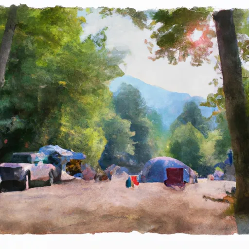
The Washington Creek Campground offers a range of amenities, including picnic tables, fire pits, and access to potable water. This campground also offers primitive camping, with no electricity or running water. There are no reservations for campsites; it is a first-come-first-serve basis. The campground offers 10 campsites, which can accommodate tents or small RVs.
One interesting fact about Washington Creek Campground is that it is located near the site of the historic Benton MacKaye Trail, named after the founder of the Appalachian Trail. The Benton MacKaye Trail is a 300-mile hiking trail through the Appalachian Mountains that offers spectacular views and a challenging trek for experienced hikers.
The best time to visit Washington Creek Campground is during the summer months, from June to August. The average temperature during this time is around 75 degrees Fahrenheit, making it an ideal time for outdoor adventures. However, visitors should be aware that this is also the busiest time of year, and campsites may fill up quickly.
What's on-site at Washington Creek Campground
Key facilities Snoflo tracks for this campground. Confirm with the operator before booking -- amenities can change seasonally.
Plan your trip down to the hour
Same weather feed Snoflo's iOS app uses -- updated continuously from NOAA / yr.no.
Next 5 days, hour by hour
Temperature line with weather symbols on top, snow + rain accumulation as columns, humidity as a dotted line.
5-day forecast table
Every 3 hours, broken out across temperature, snow, rain, humidity, and wind. Each cell is colour-coded relative to the column min/max so trends jump out at a glance.
| Time | Condition | Temp (°F) | Snow (in) | Rain (in) | Humidity (%) | Wind (mps) | Wind dir |
|---|---|---|---|---|---|---|---|
| Loading detailed forecast… | |||||||
15-day temperature & precipitation
Daily temperatures, snow, and rain projected over the next two weeks. Hover any point for the full breakdown.
Other campgrounds in the area
Snoflo-tracked campsites within driving distance of Washington Creek Campground, with reservations status.
| Campground | Reservations | Toilets | View |
|---|---|---|---|
| Beaver Island Campground | ✗ | ✗ | → |
| Beaver Island | ✗ | ✗ | → |
| Huginnin Cove | ✗ | ✗ | → |
| Huginnin Cove Campground | ✗ | ✗ | → |
| Grace Island | ✗ | ✗ | → |
Nearby streamflow
USGS streamgauges within reach of Washington Creek Campground -- pulled live from the National Water Information System.
| Streamgauge | Discharge | View |
|---|---|---|
| Pigeon River At Middle Falls Nr Grand Portage Mn | 108 cfs | → |
| Trap Rock River Near Lake Linden | 4 cfs | → |
Nearby snow depths
NRCS SNOTEL stations within reach of Washington Creek Campground -- relevant when planning a shoulder-season or alpine trip.
| SNOTEL station | Snowpack | 24h Snowfall | View |
|---|---|---|---|
| Nohrsc Hovland 6.5 Wsw | 0.0 in | 4.8 in | → |
Plan a longer trip
The closest parks, lakes, boat launches, and paddle runs so a camping night can grow into a full weekend.
Camping essentials & Leave No Trace
- Pack it in, pack it out
- Take all trash, food scraps, and gear back with you to keep campsites clean and protect wildlife.
- Respect wildlife
- Observe animals from a distance, store food securely, and never feed wildlife to maintain natural behavior and safety.
- Know before you go
- Check weather, fire restrictions, trail conditions, and permit requirements to ensure a safe and well-planned trip.
- Minimize campfire impact
- Use established fire rings, keep fires small, fully extinguish them, or opt for a camp stove when fires are restricted.
- Leave what you find
- Preserve natural and cultural features by avoiding removal of plants, rocks, artifacts, or other elements of the environment.
Set push alerts in the Snoflo app
Save Washington Creek Campground as a favorite, set a custom threshold (precipitation, snowpack, freezing temperatures), and the iOS app will push the moment conditions cross.
About Washington Creek Campground
Can I make reservations at Washington Creek Campground?
This campground does not appear to accept reservations -- it's typically first-come, first-served. Arrive early on summer weekends.
How fresh is the weather data on this page?
The hourly forecast updates throughout the day from the NOAA / yr.no public feeds. Streamflow data is pulled live from USGS streamgauges and snowpack from the NRCS SNOTEL network.
What's the best time of year to visit?
Use the 15-day temperature & precipitation outlook on this page to plan -- pick a window with comfortable temperatures and low precipitation. For longer trips, the 5-day hourly meteogram shows snow + rain accumulation hour-by-hour.
How do I get to Washington Creek Campground?
Tap Directions in the hero above to open driving directions in Google Maps, or Open in map to center the Snoflo interactive map on the campground.
Can I get alerts when conditions change?
Yes -- alerts are managed through the Snoflo iOS app. Favorite this campground, set a threshold (temperature, snowpack, precipitation), and you'll get a push the moment it crosses.
Other campgrounds near here
Snoflo-tracked campgrounds within driving distance of Washington Creek Campground.