Timpooneke Campground
Community Reviews
Been here? Share the conditions.
Reviews, ratings & photos are added in the free Snoflo iOS app — rate a spot, tag the conditions, and your visit is verified by location. Add or manage your reviews from the app.
Timpooneke
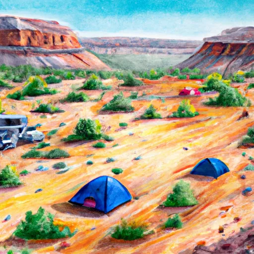
The campground offers amenities such as fire rings, picnic tables, vault toilets, and potable water. It has 22 campsites with a mix of reservable and first-come, first-served sites. The campground can accommodate RVs, but there are no hookups available.
Timpooneke Camping Area is known for its beautiful wildflowers, and it's not uncommon to see moose and other wildlife roaming around the area. Interestingly, the name Timpooneke is derived from a Native American word meaning "rocky mouth of the canyon."
The best time to visit Timpooneke Camping Area is during the summer months, from June to August. The average temperature during this time is around 70°F during the day and 40°F at night, making it the ideal time for outdoor activities. However, it's important to note that the campground may experience heavy snowfall during the winter months, making it inaccessible.
What's on-site at Timpooneke
Key facilities Snoflo tracks for this campground. Confirm with the operator before booking -- amenities can change seasonally.
Plan your trip down to the hour
Same weather feed Snoflo's iOS app uses -- updated continuously from NOAA / yr.no.
Next 5 days, hour by hour
Temperature line with weather symbols on top, snow + rain accumulation as columns, humidity as a dotted line.
5-day forecast table
Every 3 hours, broken out across temperature, snow, rain, humidity, and wind. Each cell is colour-coded relative to the column min/max so trends jump out at a glance.
| Time | Condition | Temp (°F) | Snow (in) | Rain (in) | Humidity (%) | Wind (mps) | Wind dir |
|---|---|---|---|---|---|---|---|
| Loading detailed forecast… | |||||||
15-day temperature & precipitation
Daily temperatures, snow, and rain projected over the next two weeks. Hover any point for the full breakdown.
Other campgrounds in the area
Snoflo-tracked campsites within driving distance of Timpooneke, with reservations status.
| Campground | Reservations | Toilets | View |
|---|---|---|---|
| Timponeeke Campground | ✓ | ✗ | → |
| Site 1 | ✗ | ✗ | → |
| Site 2 | ✗ | ✗ | → |
| Altamont Group Campground | ✓ | ✗ | → |
| Site 13 | ✗ | ✗ | → |
Nearby streamflow
USGS streamgauges within reach of Timpooneke -- pulled live from the National Water Information System.
| Streamgauge | Discharge | View |
|---|---|---|
| American Fk Ab Upper Powerplant Nr American Fk | 19 cfs | → |
| Daniels Creek At Charleston | · | → |
| Snake Creek Near Charleston | 23 cfs | → |
| Provo River Near Charleston | 223 cfs | → |
| Provo River At Provo | 48 cfs | → |
| Provo River At River Road Bridge | 172 cfs | → |
Nearby snow depths
NRCS SNOTEL stations within reach of Timpooneke -- relevant when planning a shoulder-season or alpine trip.
| SNOTEL station | Snowpack | 24h Snowfall | View |
|---|---|---|---|
| Nohrsc Timpanogos Divide | 0.0 in | 0.0 in | → |
| Timpanogos Divide | 0.0 in | 0.0 in | → |
| Aspen Grove | 5.0 in | 0.0 in | → |
| Tibble Fork | 0.0 in | 0.0 in | → |
| Lone Peak - Timpanogos Cave | 0.0 in | 0.0 in | → |
| Sundance - Mid Mnt | 217.8 in | 0.0 in | → |
Plan a longer trip
The closest parks, lakes, boat launches, and paddle runs so a camping night can grow into a full weekend.
Parks
- Wilderness Lone Peak
- Deer Creek State Park
- Wilderness Mount Timpanogos
- Manila Park
- State Wildlife Area Timpanogos
- Beehive And Central League Park
Boat launches
- State Route 314 Wasatch County
- Deer Creek Island
- Deer Creek State Park- Charleston Day Use Area
- Lindon Boat Harbor
- North Vineyard Road 4888, Vineyard
- American Fork Boat Harbor
Fishing spots
Points of interest
- Timp Falls View Point
- Pioneer Museum
- American Fork Amphitheater At Quail Cove
- Henry & Elizabeth Parker Chipman House
- Thomas & Elizabeth Coddington House
- Dunn-Binnall House & Farmstead
Paddle runs
- Confluence Below Timpooneke To Mt Timpanogos Wilderness Boundary
- Mt Timpanogos Wilderenss Boundary To Scout Falls
- Headwater Spring In Sec 8 To Mt Timpanogos Wilderness Boundary
- Mt Timpanogos Wilderness Boundary To Theater-In-The-Pines
- Eastern Boundary Of National Monument To Western Boundary Of National Monument
- Tibble Res Down
Camping essentials & Leave No Trace
- Pack it in, pack it out
- Take all trash, food scraps, and gear back with you to keep campsites clean and protect wildlife.
- Respect wildlife
- Observe animals from a distance, store food securely, and never feed wildlife to maintain natural behavior and safety.
- Know before you go
- Check weather, fire restrictions, trail conditions, and permit requirements to ensure a safe and well-planned trip.
- Minimize campfire impact
- Use established fire rings, keep fires small, fully extinguish them, or opt for a camp stove when fires are restricted.
- Leave what you find
- Preserve natural and cultural features by avoiding removal of plants, rocks, artifacts, or other elements of the environment.
Set push alerts in the Snoflo app
Save Timpooneke as a favorite, set a custom threshold (precipitation, snowpack, freezing temperatures), and the iOS app will push the moment conditions cross.
About Timpooneke
Can I make reservations at Timpooneke?
Yes -- this campground accepts reservations. Snoflo recommends booking early for peak season; check the operator (Recreation.gov / state park system / private operator) for the booking window and cancellation policy.
How fresh is the weather data on this page?
The hourly forecast updates throughout the day from the NOAA / yr.no public feeds. Streamflow data is pulled live from USGS streamgauges and snowpack from the NRCS SNOTEL network.
What's the best time of year to visit?
Use the 15-day temperature & precipitation outlook on this page to plan -- pick a window with comfortable temperatures and low precipitation. For longer trips, the 5-day hourly meteogram shows snow + rain accumulation hour-by-hour.
How do I get to Timpooneke?
Tap Directions in the hero above to open driving directions in Google Maps, or Open in map to center the Snoflo interactive map on the campground.
Can I get alerts when conditions change?
Yes -- alerts are managed through the Snoflo iOS app. Favorite this campground, set a threshold (temperature, snowpack, precipitation), and you'll get a push the moment it crosses.
Other campgrounds near here
Snoflo-tracked campgrounds within driving distance of Timpooneke.