Swains Lock Hiker-Biker Campsite campground
Community Reviews
Been here? Share the conditions.
Reviews, ratings & photos are added in the free Snoflo iOS app — rate a spot, tag the conditions, and your visit is verified by location. Add or manage your reviews from the app.
Swains Lock Hiker-Biker Campsite
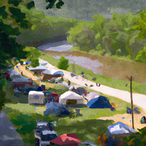
Surrounding Views:
The campsite is located on the banks of the Potomac River and provides stunning views of the river and the surrounding lush greenery. The natural beauty of the park is truly breathtaking and is perfect for hiking, biking, and fishing enthusiasts.
Nearby Points of Interest:
Swains Lock Hiker-Biker Campsite is located near several interesting attractions, including the Great Falls Park, which is a popular spot for rock climbing and hiking. The park is also home to a variety of wildlife, including bald eagles, deer, and foxes. The Billy Goat Trail is another popular attraction in the area, offering visitors a challenging hike through rocky terrain.
Campground Amenities:
The campsite has basic amenities, such as portable toilets, picnic tables, and fire rings. However, there is no running water or electricity on-site. The campground accommodates up to 30 people and is available on a first-come, first-served basis.
Interesting Facts:
The Chesapeake & Ohio Canal National Historical Park was established in 1971 and is home to several historic sites, including the Great Falls Tavern and Lockhouse 10. The park covers over 184 miles and runs from Washington D.C. to Cumberland, Maryland.
Best Time of Year to Visit:
The best time to visit Swains Lock Hiker-Biker Campsite is from April to October when the weather is mild, and the park is in full bloom. The average temperature during this time ranges from 60 to 80 degrees Fahrenheit.
In summary, Swains Lock Hiker-Biker Campsite is an ideal spot for those who love the outdoors and want to explore the Chesapeake & Ohio Canal National Historical Park. The campsite offers stunning views, nearby points of interest, basic amenities, and interesting facts about the area. The best time to visit is from April to October with average temperatures ranging from 60 to 80 degrees Fahrenheit.
What's on-site at Swains Lock Hiker-Biker Campsite
Key facilities Snoflo tracks for this campground. Confirm with the operator before booking -- amenities can change seasonally.
Plan your trip down to the hour
Same weather feed Snoflo's iOS app uses -- updated continuously from NOAA / yr.no.
Next 5 days, hour by hour
Temperature line with weather symbols on top, snow + rain accumulation as columns, humidity as a dotted line.
5-day forecast table
Every 3 hours, broken out across temperature, snow, rain, humidity, and wind. Each cell is colour-coded relative to the column min/max so trends jump out at a glance.
| Time | Condition | Temp (°F) | Snow (in) | Rain (in) | Humidity (%) | Wind (mps) | Wind dir |
|---|---|---|---|---|---|---|---|
| Loading detailed forecast… | |||||||
15-day temperature & precipitation
Daily temperatures, snow, and rain projected over the next two weeks. Hover any point for the full breakdown.
Other campgrounds in the area
Snoflo-tracked campsites within driving distance of Swains Lock Hiker-Biker Campsite, with reservations status.
| Campground | Reservations | Toilets | View |
|---|---|---|---|
| Camp Fraser | ✗ | ✗ | → |
| Marsden Tract Group Campsite | ✗ | ✗ | → |
| Marsden Tract Campground | ✗ | ✗ | → |
| Lake Fairfax | ✓ | ✗ | → |
| Horsepen Branch | ✗ | ✓ | → |
Nearby streamflow
USGS streamgauges within reach of Swains Lock Hiker-Biker Campsite -- pulled live from the National Water Information System.
| Streamgauge | Discharge | View |
|---|---|---|
| Difficult Run Near Great Falls | 10 cfs | → |
| Seneca Creek At Dawsonville | 62 cfs | → |
| Potomac River Near Wash | 3,800 cfs | → |
| Broad Run Near Leesburg | 59 cfs | → |
| Rock Creek At Sherrill Drive Washington | 82 cfs | → |
| Nw Branch Anacostia River Near Colesville | 2 cfs | → |
Nearby snow depths
NRCS SNOTEL stations within reach of Swains Lock Hiker-Biker Campsite -- relevant when planning a shoulder-season or alpine trip.
| SNOTEL station | Snowpack | 24h Snowfall | View |
|---|---|---|---|
| Dalecarlia Reservoir Coop | 0.0 in | 0.0 in | → |
| Vienna Coop | 0.0 in | 0.0 in | → |
| Montgomery Village 1.1 Ene | 0.0 in | 0.0 in | → |
| Wfo Sterling Coop | 0.0 in | 0.0 in | → |
| Ashton-Sandy Spring 1.8 Nnw | 0.0 in | 0.1 in | → |
| Damascus 3 Ssw Coop | 0.0 in | 0.0 in | → |
Plan a longer trip
The closest parks, lakes, boat launches, and paddle runs so a camping night can grow into a full weekend.
Parks
- Watts Branch Stream Valley Park
- Bedfordshire Park
- Kilgour Branch Park
- Heritage Farm Park
- Riverbend Country Park
- Glen Hills Park
Boat launches
- Potomac Hills Street Fairfax County
- Rileys Lock Road Darnestown
- Fletchers Cove
- Clarksburg Road Germantown
- Ashburn Village Boulevard 20585, Lansdowne
- Georgetown Visitor Center
Camping essentials & Leave No Trace
- Pack it in, pack it out
- Take all trash, food scraps, and gear back with you to keep campsites clean and protect wildlife.
- Respect wildlife
- Observe animals from a distance, store food securely, and never feed wildlife to maintain natural behavior and safety.
- Know before you go
- Check weather, fire restrictions, trail conditions, and permit requirements to ensure a safe and well-planned trip.
- Minimize campfire impact
- Use established fire rings, keep fires small, fully extinguish them, or opt for a camp stove when fires are restricted.
- Leave what you find
- Preserve natural and cultural features by avoiding removal of plants, rocks, artifacts, or other elements of the environment.
Set push alerts in the Snoflo app
Save Swains Lock Hiker-Biker Campsite as a favorite, set a custom threshold (precipitation, snowpack, freezing temperatures), and the iOS app will push the moment conditions cross.
About Swains Lock Hiker-Biker Campsite
Can I make reservations at Swains Lock Hiker-Biker Campsite?
This campground does not appear to accept reservations -- it's typically first-come, first-served. Arrive early on summer weekends.
How fresh is the weather data on this page?
The hourly forecast updates throughout the day from the NOAA / yr.no public feeds. Streamflow data is pulled live from USGS streamgauges and snowpack from the NRCS SNOTEL network.
What's the best time of year to visit?
Use the 15-day temperature & precipitation outlook on this page to plan -- pick a window with comfortable temperatures and low precipitation. For longer trips, the 5-day hourly meteogram shows snow + rain accumulation hour-by-hour.
How do I get to Swains Lock Hiker-Biker Campsite?
Tap Directions in the hero above to open driving directions in Google Maps, or Open in map to center the Snoflo interactive map on the campground.
Can I get alerts when conditions change?
Yes -- alerts are managed through the Snoflo iOS app. Favorite this campground, set a threshold (temperature, snowpack, precipitation), and you'll get a push the moment it crosses.
Other campgrounds near here
Snoflo-tracked campgrounds within driving distance of Swains Lock Hiker-Biker Campsite.