Adams Fork Campground
Community Reviews
Been here? Share the conditions.
Reviews, ratings & photos are added in the free Snoflo iOS app — rate a spot, tag the conditions, and your visit is verified by location. Add or manage your reviews from the app.
Adams Fork
Reservations are not accepted at this campground, and it operates on a first-come, first-served basis. Therefore, it is advisable to arrive early to secure a camping spot, especially during peak seasons. The best time to visit Adams Fork Camping Area is during the summer months when the weather is mild and conducive to outdoor activities. However, it is important to note that the campground is only accessible via a rough gravel road, so additional caution should be exercised while driving.
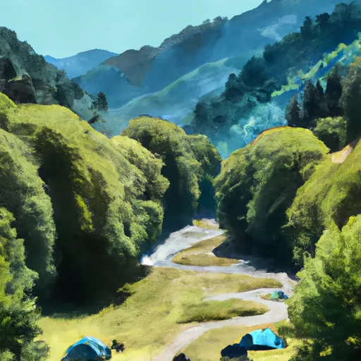
While staying at Adams Fork Camping Area, campers can enjoy the serene atmosphere and the breathtaking scenery surrounding them. However, it is essential to be aware of potential wildlife encounters, as the area is known for black bear sightings. Visitors should take necessary precautions such as properly storing food and keeping a safe distance from any wildlife they may encounter. With its amenities and natural beauty, Adams Fork Camping Area offers a wonderful camping experience for those looking to immerse themselves in the great outdoors.
What's on-site at Adams Fork
Key facilities Snoflo tracks for this campground. Confirm with the operator before booking -- amenities can change seasonally.
Plan your trip down to the hour
Same weather feed Snoflo's iOS app uses -- updated continuously from NOAA / yr.no.
Next 5 days, hour by hour
Temperature line with weather symbols on top, snow + rain accumulation as columns, humidity as a dotted line.
5-day forecast table
Every 3 hours, broken out across temperature, snow, rain, humidity, and wind. Each cell is colour-coded relative to the column min/max so trends jump out at a glance.
| Time | Condition | Temp (°F) | Snow (in) | Rain (in) | Humidity (%) | Wind (mps) | Wind dir |
|---|---|---|---|---|---|---|---|
| Loading detailed forecast… | |||||||
15-day temperature & precipitation
Daily temperatures, snow, and rain projected over the next two weeks. Hover any point for the full breakdown.
Other campgrounds in the area
Snoflo-tracked campsites within driving distance of Adams Fork, with reservations status.
| Campground | Reservations | Toilets | View |
|---|---|---|---|
| Adams Fork Campground | ✗ | ✗ | → |
| Campground: Adams Fork | ✓ | ✗ | → |
| Cat Creek Campground | ✗ | ✗ | → |
| Cat Creek | ✗ | ✓ | → |
| Cat Creek Chimney | ✗ | ✓ | → |
Nearby streamflow
USGS streamgauges within reach of Adams Fork -- pulled live from the National Water Information System.
| Streamgauge | Discharge | View |
|---|---|---|
| Cispus River Ab Yellowjacket Creek Near Randle | 419 cfs | → |
| Cowlitz River At Packwood | 554 cfs | → |
| Klickitat River Above West Fork Near Glenwood | 71 cfs | → |
| Cowlitz River At Randle | 935 cfs | → |
| Cowlitz River Near Kosmos | 2,020 cfs | → |
| Muddy Creek Below Clear Creek Near Cougar | 150 cfs | → |
Nearby snow depths
NRCS SNOTEL stations within reach of Adams Fork -- relevant when planning a shoulder-season or alpine trip.
| SNOTEL station | Snowpack | 24h Snowfall | View |
|---|---|---|---|
| Nohrsc Potato Hill | 0.0 in | 0.0 in | → |
| Potato Hill | 0.0 in | 0.0 in | → |
| Pinto Rock | 0.0 in | 0.0 in | → |
| Nohrsc Pinto Rock | 0.0 in | 0.0 in | → |
| Lone Pine | 1.0 in | 1.0 in | → |
| Nohrsc Lone Pine | 0.0 in | 0.0 in | → |
Plan a longer trip
The closest parks, lakes, boat launches, and paddle runs so a camping night can grow into a full weekend.
Parks
- Wilderness Goat Rocks
- Wilderness Mount Adams
- Mount Baker-Snoqualmie National Forest
- Wilderness Tatoosh
- Wilderness William O. Douglas
- Guler Mount Adams County Park
Boat launches
Points of interest
- Basket Tree Interpretive Site
- Site: Woods Creek Watchable Wildlife Area Tr. #247
- Berry Fields Interpretive Site
- White Pass Country Historical Museum
- Forest Road 25
- Historic Packwood Station
Paddle runs
- Headwaters In Ne1/4 Of Sec 35, T9n, R10e To Mt. Adams Wilderness Boundary
- Headwaters In Sw1/4 Of Sec 27, T12n, R11e To Goat Rocks Wilderness Boundary
- Road 2809 Bridge Crossing In Sw1/4 Of Sec 8, T10n, R8e To Nw1/4 Of Sec 21, T11n, R8e
- Nw1/4 Of Sec 21, T11n, R8e To Confluence With Cispus River
- Headwaters In Sw 1/4 Of Sec 18, T9n, R9e To Confluence With Straight Creek
- Straight Creek To Confluence With Lewis River
Camping essentials & Leave No Trace
- Pack it in, pack it out
- Take all trash, food scraps, and gear back with you to keep campsites clean and protect wildlife.
- Respect wildlife
- Observe animals from a distance, store food securely, and never feed wildlife to maintain natural behavior and safety.
- Know before you go
- Check weather, fire restrictions, trail conditions, and permit requirements to ensure a safe and well-planned trip.
- Minimize campfire impact
- Use established fire rings, keep fires small, fully extinguish them, or opt for a camp stove when fires are restricted.
- Leave what you find
- Preserve natural and cultural features by avoiding removal of plants, rocks, artifacts, or other elements of the environment.
Set push alerts in the Snoflo app
Save Adams Fork as a favorite, set a custom threshold (precipitation, snowpack, freezing temperatures), and the iOS app will push the moment conditions cross.
About Adams Fork
Can I make reservations at Adams Fork?
Yes -- this campground accepts reservations. Snoflo recommends booking early for peak season; check the operator (Recreation.gov / state park system / private operator) for the booking window and cancellation policy.
How fresh is the weather data on this page?
The hourly forecast updates throughout the day from the NOAA / yr.no public feeds. Streamflow data is pulled live from USGS streamgauges and snowpack from the NRCS SNOTEL network.
What's the best time of year to visit?
Use the 15-day temperature & precipitation outlook on this page to plan -- pick a window with comfortable temperatures and low precipitation. For longer trips, the 5-day hourly meteogram shows snow + rain accumulation hour-by-hour.
How do I get to Adams Fork?
Tap Directions in the hero above to open driving directions in Google Maps, or Open in map to center the Snoflo interactive map on the campground.
Can I get alerts when conditions change?
Yes -- alerts are managed through the Snoflo iOS app. Favorite this campground, set a threshold (temperature, snowpack, precipitation), and you'll get a push the moment it crosses.
Other campgrounds near here
Snoflo-tracked campgrounds within driving distance of Adams Fork.