Dosewallips State Park Camping Campground
Community Reviews
Been here? Share the conditions.
Reviews, ratings & photos are added in the free Snoflo iOS app — rate a spot, tag the conditions, and your visit is verified by location. Add or manage your reviews from the app.
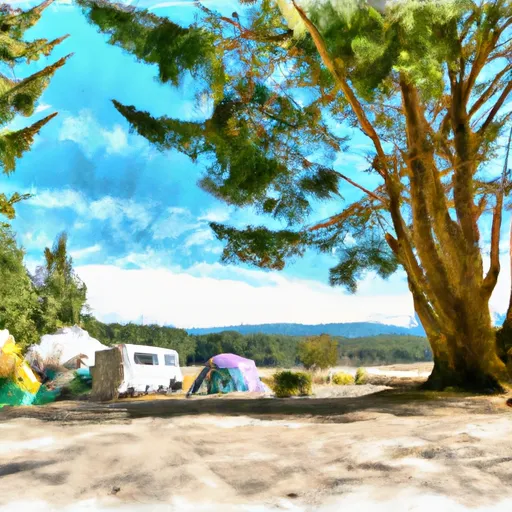
Dosewallips State Park Camping
Reservations are accepted at Dosewallips State Park Camping, providing campers with the convenience of securing a spot in advance. It is recommended to make reservations, especially during peak season, to ensure availability. The campground operates on a first-come, first-served basis for walk-in visitors.
The best time to visit Dosewallips State Park Camping is during the summer months when the weather is mild and ideal for outdoor activities. The park offers opportunities for hiking, fishing, boating, and wildlife viewing. The scenic beauty of the surrounding area, including the Dosewallips River and nearby Olympic National Park, adds to the charm of the campground.
While enjoying the camping area, campers should be cautious of wildlife encounters, including bears and cougars, and follow recommended safety guidelines. Additionally, it is important to be mindful of weather conditions and pack appropriate gear for rain or colder temperatures, as the region can experience unpredictable weather patterns. Overall, Dosewallips State Park Camping provides a comfortable and scenic camping experience for outdoor enthusiasts.
What's on-site at Dosewallips State Park Camping
Key facilities Snoflo tracks for this campground. Confirm with the operator before booking -- amenities can change seasonally.
Plan your trip down to the hour
Same weather feed Snoflo's iOS app uses -- updated continuously from NOAA / yr.no.
Next 5 days, hour by hour
Temperature line with weather symbols on top, snow + rain accumulation as columns, humidity as a dotted line.
5-day forecast table
Every 3 hours, broken out across temperature, snow, rain, humidity, and wind. Each cell is colour-coded relative to the column min/max so trends jump out at a glance.
| Time | Condition | Temp (°F) | Snow (in) | Rain (in) | Humidity (%) | Wind (mps) | Wind dir |
|---|---|---|---|---|---|---|---|
| Loading detailed forecast… | |||||||
15-day temperature & precipitation
Daily temperatures, snow, and rain projected over the next two weeks. Hover any point for the full breakdown.
Other campgrounds in the area
Snoflo-tracked campsites within driving distance of Dosewallips State Park Camping, with reservations status.
| Campground | Reservations | Toilets | View |
|---|---|---|---|
| Dosewallips State Park | ✓ | ✗ | → |
| Hiker Biker Campsites | ✗ | ✗ | → |
| Seal Rock Campground | ✗ | ✗ | → |
| Seal Rock | ✗ | ✓ | → |
| Hiker/Biker Campsites | ✗ | ✗ | → |
Nearby streamflow
USGS streamgauges within reach of Dosewallips State Park Camping -- pulled live from the National Water Information System.
| Streamgauge | Discharge | View |
|---|---|---|
| Duckabush River Near Brinnon | 48 cfs | → |
| Big Quilcene River Below Diversion Nr Quilcene | 26 cfs | → |
| Huge Creek Near Wauna | 5 cfs | → |
| Nf Skokomish R Bl Staircase Rpds Nr Hoodsport | 37 cfs | → |
| Dungeness River Near Sequim | 106 cfs | → |
| Thornton Creek Near Seattle | 41 cfs | → |
Nearby snow depths
NRCS SNOTEL stations within reach of Dosewallips State Park Camping -- relevant when planning a shoulder-season or alpine trip.
| SNOTEL station | Snowpack | 24h Snowfall | View |
|---|---|---|---|
| Nohrsc Mount Crag | 0.0 in | 0.0 in | → |
| Mount Crag | 0.0 in | 0.0 in | → |
| Dungeness | 5.0 in | 0.0 in | → |
| Dungeness | 0.0 in | -1.0 in | → |
| Buckinghorse | 0.0 in | 0.0 in | → |
| Nohrsc Buckinghorse | 0.0 in | 0.0 in | → |
Plan a longer trip
The closest parks, lakes, boat launches, and paddle runs so a camping night can grow into a full weekend.
Parks
- Dosewallips State Park
- Scenic Beach State Park
- Anderson Landing County Park
- Wildcat Lake County Park
- Howerton Soccer Fields
- Wilderness The Brothers
Boat launches
- Pleasant Harbor
- Misery Point
- Miami Beach Road Northwest 9810, Seabeck
- Point Whitney Road 1099, Brinnon
- Triton Cove
- Quilcene Marina
Points of interest
- Mt. Walker Viewpoint
- Quilcene Historical Museum
- Poulsbo Maritime Museum
- Nad Park F-8 Crusader
- Front Street Gallery
- Stix & Stones
Paddle runs
- Brothers Wilderness Boundary To Olympic Nf Boundary
- Olympic Nf/Olympic Np Bounary To Brothers Wilderness Boundary
- Headwaters- Includes All Tributaries (Upstream From Station Creek) To Confluence With Dosewallips River
- Headwaters- Includes All Tributaries To Confluence With Dosewallips River
Camping essentials & Leave No Trace
- Pack it in, pack it out
- Take all trash, food scraps, and gear back with you to keep campsites clean and protect wildlife.
- Respect wildlife
- Observe animals from a distance, store food securely, and never feed wildlife to maintain natural behavior and safety.
- Know before you go
- Check weather, fire restrictions, trail conditions, and permit requirements to ensure a safe and well-planned trip.
- Minimize campfire impact
- Use established fire rings, keep fires small, fully extinguish them, or opt for a camp stove when fires are restricted.
- Leave what you find
- Preserve natural and cultural features by avoiding removal of plants, rocks, artifacts, or other elements of the environment.
Set push alerts in the Snoflo app
Save Dosewallips State Park Camping as a favorite, set a custom threshold (precipitation, snowpack, freezing temperatures), and the iOS app will push the moment conditions cross.
About Dosewallips State Park Camping
Can I make reservations at Dosewallips State Park Camping?
This campground does not appear to accept reservations -- it's typically first-come, first-served. Arrive early on summer weekends.
How fresh is the weather data on this page?
The hourly forecast updates throughout the day from the NOAA / yr.no public feeds. Streamflow data is pulled live from USGS streamgauges and snowpack from the NRCS SNOTEL network.
What's the best time of year to visit?
Use the 15-day temperature & precipitation outlook on this page to plan -- pick a window with comfortable temperatures and low precipitation. For longer trips, the 5-day hourly meteogram shows snow + rain accumulation hour-by-hour.
How do I get to Dosewallips State Park Camping?
Tap Directions in the hero above to open driving directions in Google Maps, or Open in map to center the Snoflo interactive map on the campground.
Can I get alerts when conditions change?
Yes -- alerts are managed through the Snoflo iOS app. Favorite this campground, set a threshold (temperature, snowpack, precipitation), and you'll get a push the moment it crosses.
Other campgrounds near here
Snoflo-tracked campgrounds within driving distance of Dosewallips State Park Camping.