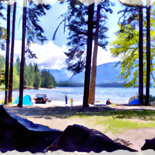
Lake Wenatchee State Park Campground
Community Reviews
Been here? Share the conditions.
Reviews, ratings & photos are added in the free Snoflo iOS app — rate a spot, tag the conditions, and your visit is verified by location. Add or manage your reviews from the app.
Lake Wenatchee State Park
Reservations are accepted at Lake Wenatchee State Park, which is recommended especially during peak season. The campground is open year-round, offering different experiences depending on the time of year you choose to visit. During the summer months, campers can enjoy swimming, boating, and fishing in the crystal-clear lake. The park also has a sandy beach area for sunbathing and relaxing. In the winter, the campground becomes a haven for snow enthusiasts, with opportunities for cross-country skiing, snowshoeing, and snowmobiling. The park is situated near recreational trails, making it an ideal destination for outdoor enthusiasts.
While enjoying your time at Lake Wenatchee State Park, it is important to be cautious of wildlife in the area, especially bears. Campers should take necessary precautions, such as storing food properly and following guidelines provided by park authorities. Additionally, it is recommended to pack insect repellent as mosquitoes can be prevalent in the area during certain times of the year. Overall, Lake Wenatchee State Park offers a beautiful and well-equipped campground for nature lovers and outdoor enthusiasts to enjoy year-round.
What's on-site at Lake Wenatchee State Park
Key facilities Snoflo tracks for this campground. Confirm with the operator before booking -- amenities can change seasonally.
Plan your trip down to the hour
Same weather feed Snoflo's iOS app uses -- updated continuously from NOAA / yr.no.
Next 5 days, hour by hour
Temperature line with weather symbols on top, snow + rain accumulation as columns, humidity as a dotted line.
5-day forecast table
Every 3 hours, broken out across temperature, snow, rain, humidity, and wind. Each cell is colour-coded relative to the column min/max so trends jump out at a glance.
| Time | Condition | Temp (°F) | Snow (in) | Rain (in) | Humidity (%) | Wind (mps) | Wind dir |
|---|---|---|---|---|---|---|---|
| Loading detailed forecast… | |||||||
15-day temperature & precipitation
Daily temperatures, snow, and rain projected over the next two weeks. Hover any point for the full breakdown.
Other campgrounds in the area
Snoflo-tracked campsites within driving distance of Lake Wenatchee State Park, with reservations status.
| Campground | Reservations | Toilets | View |
|---|---|---|---|
| Lake Wenatchee State Park Camp | ✗ | ✗ | → |
| Lake Wenatchee Ymca Camp | ✗ | ✗ | → |
| Nason Creek Campground | ✓ | ✗ | → |
| Nason Creek | ✗ | ✓ | → |
| Glacier View Campground | ✗ | ✗ | → |
Nearby streamflow
USGS streamgauges within reach of Lake Wenatchee State Park -- pulled live from the National Water Information System.
| Streamgauge | Discharge | View |
|---|---|---|
| Chiwawa River Near Plain | 232 cfs | → |
| Wenatchee River At Plain | 842 cfs | → |
| Entiat River Near Ardenvoir | 166 cfs | → |
| Wenatchee River At Peshastin | 994 cfs | → |
| Mad River At Ardenvoir | 21 cfs | → |
| Icicle Creek Above Snow Creek Near Leavenworth | 208 cfs | → |
Nearby snow depths
NRCS SNOTEL stations within reach of Lake Wenatchee State Park -- relevant when planning a shoulder-season or alpine trip.
| SNOTEL station | Snowpack | 24h Snowfall | View |
|---|---|---|---|
| Plain | 0.0 in | 0.0 in | → |
| Berne | 2.6 in | 0.0 in | → |
| Nohrsc Pope Ridge | 0.0 in | 0.0 in | → |
| Pope Ridge | 0.0 in | 0.0 in | → |
| Leavenworth | 0.0 in | 0.0 in | → |
| Stevens Pass | 0.0 in | -1.0 in | → |
Plan a longer trip
The closest parks, lakes, boat launches, and paddle runs so a camping night can grow into a full weekend.
Parks
- Lake Wenatchee State Park
- Wilderness Glacier Peak
- Lion's Club Park
- Peshastin Pinnacles State Park
- Wilderness Lake Chelan-Sawtooth
- Wilderness Wild Sky
Boat launches
- Lake Wenatchee State Park
- Cove Resort
- Cascade Hideaway Resort
- Leavenworth Public Boat Launch
- Icicle Creek
- Wenatchee River
Points of interest
- Leavenworth Ziplines
- Reindeer Lodge
- Box Canyon Viewpoint
- Entiat Falls Viewpoint
- Bygone Byways Trailhead
- Loge Riverside Cabins
Paddle runs
- Point At East Section Line Of Sec 13, T28n, R15e To Lake Wenatchee
- Glacier Peak Wilderness Boundary To Confluence With Wenatchee River
- Headwaters In Sw1/4 Of Sec 21, T30n, R15e To Glacier Peak Wilderness Boundary And Including Twin Lakes Creek In Secs 16/17, T28n, R16e
- Glacier Peak Wilderness Boundary To Confluence With White River
- Glacier Peak Wilderness Boundary To A Point Approximately 0.5 Mile Above The Tall Timbers Range At East Section Line Of Sec 13, T28n, R15e
- Headwaters In Sw1/4 Of Sec 5, T29n, R14e To Glacier Peak Wilderness Boundary
Camping essentials & Leave No Trace
- Pack it in, pack it out
- Take all trash, food scraps, and gear back with you to keep campsites clean and protect wildlife.
- Respect wildlife
- Observe animals from a distance, store food securely, and never feed wildlife to maintain natural behavior and safety.
- Know before you go
- Check weather, fire restrictions, trail conditions, and permit requirements to ensure a safe and well-planned trip.
- Minimize campfire impact
- Use established fire rings, keep fires small, fully extinguish them, or opt for a camp stove when fires are restricted.
- Leave what you find
- Preserve natural and cultural features by avoiding removal of plants, rocks, artifacts, or other elements of the environment.
Set push alerts in the Snoflo app
Save Lake Wenatchee State Park as a favorite, set a custom threshold (precipitation, snowpack, freezing temperatures), and the iOS app will push the moment conditions cross.
About Lake Wenatchee State Park
Can I make reservations at Lake Wenatchee State Park?
Yes -- this campground accepts reservations. Snoflo recommends booking early for peak season; check the operator (Recreation.gov / state park system / private operator) for the booking window and cancellation policy.
How fresh is the weather data on this page?
The hourly forecast updates throughout the day from the NOAA / yr.no public feeds. Streamflow data is pulled live from USGS streamgauges and snowpack from the NRCS SNOTEL network.
What's the best time of year to visit?
Use the 15-day temperature & precipitation outlook on this page to plan -- pick a window with comfortable temperatures and low precipitation. For longer trips, the 5-day hourly meteogram shows snow + rain accumulation hour-by-hour.
How do I get to Lake Wenatchee State Park?
Tap Directions in the hero above to open driving directions in Google Maps, or Open in map to center the Snoflo interactive map on the campground.
Can I get alerts when conditions change?
Yes -- alerts are managed through the Snoflo iOS app. Favorite this campground, set a threshold (temperature, snowpack, precipitation), and you'll get a push the moment it crosses.
Other campgrounds near here
Snoflo-tracked campgrounds within driving distance of Lake Wenatchee State Park.