Marble Creek Campground campground
Community Reviews
Been here? Share the conditions.
Reviews, ratings & photos are added in the free Snoflo iOS app — rate a spot, tag the conditions, and your visit is verified by location. Add or manage your reviews from the app.
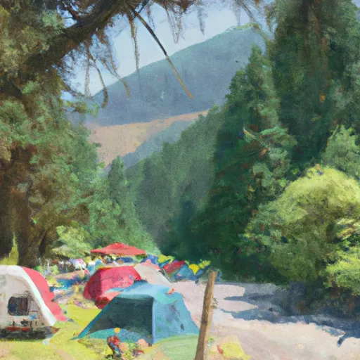
Marble Creek Campground
Reservations are not accepted at Marble Creek Campground. It operates on a first-come, first-served basis, so it is recommended to arrive early to secure a campsite, especially during peak seasons. The best time to visit the campground is during the summer months when the weather is pleasant and the camping area is bustling with activity. However, be prepared for cooler temperatures at night, even during the summer.
While camping at Marble Creek Campground, visitors can explore the surrounding area and enjoy a variety of outdoor activities. Hiking enthusiasts will find a number of trails nearby, offering stunning views of the surrounding mountains and forests. It is essential to be cautious of wildlife, such as bears and cougars, and to properly store food to avoid attracting them. Overall, Marble Creek Campground is a fantastic destination for nature lovers seeking a peaceful and picturesque camping experience in Washington state.
What's on-site at Marble Creek Campground
Key facilities Snoflo tracks for this campground. Confirm with the operator before booking -- amenities can change seasonally.
Plan your trip down to the hour
Same weather feed Snoflo's iOS app uses -- updated continuously from NOAA / yr.no.
Next 5 days, hour by hour
Temperature line with weather symbols on top, snow + rain accumulation as columns, humidity as a dotted line.
5-day forecast table
Every 3 hours, broken out across temperature, snow, rain, humidity, and wind. Each cell is colour-coded relative to the column min/max so trends jump out at a glance.
| Time | Condition | Temp (°F) | Snow (in) | Rain (in) | Humidity (%) | Wind (mps) | Wind dir |
|---|---|---|---|---|---|---|---|
| Loading detailed forecast… | |||||||
15-day temperature & precipitation
Daily temperatures, snow, and rain projected over the next two weeks. Hover any point for the full breakdown.
Other campgrounds in the area
Snoflo-tracked campsites within driving distance of Marble Creek Campground, with reservations status.
| Campground | Reservations | Toilets | View |
|---|---|---|---|
| Marble Creek | ✓ | ✓ | → |
| Monogram Lake | ✗ | ✗ | → |
| Cascade Wagon Road Campground | ✗ | ✗ | → |
| Mineral Park Campground | ✗ | ✗ | → |
| Mineral Park | ✓ | ✓ | → |
Nearby streamflow
USGS streamgauges within reach of Marble Creek Campground -- pulled live from the National Water Information System.
| Streamgauge | Discharge | View |
|---|---|---|
| Cascade River At Marblemount | 801 cfs | → |
| Skagit River At Marblemount | 4,440 cfs | → |
| Bacon Creek Below Oakes Creek Near Marblemount | 213 cfs | → |
| Newhalem Creek Near Newhalem | 32 cfs | → |
| Skagit River At Newhalem | 3,730 cfs | → |
| Thunder Creek Near Newhalem | 1,090 cfs | → |
Nearby snow depths
NRCS SNOTEL stations within reach of Marble Creek Campground -- relevant when planning a shoulder-season or alpine trip.
| SNOTEL station | Snowpack | 24h Snowfall | View |
|---|---|---|---|
| Newhalem | 0.0 in | 0.0 in | → |
| Nohrsc Thunder Basin | 0.0 in | 0.0 in | → |
| Thunder Basin | 0.0 in | 0.0 in | → |
| Diablo Reservoir | 0.0 in | 0.0 in | → |
| Diablo Dam | 0.0 in | 0.0 in | → |
| Nohrsc Park Creek Ridge | 1.0 in | 0.0 in | → |
Plan a longer trip
The closest parks, lakes, boat launches, and paddle runs so a camping night can grow into a full weekend.
Parks
- Ross Lake National Recreation Area
- Wilderness Noisy-Diobsud
- Rockport State Park
- Upper Skagit Garden Club Park
- North Cascades National Park
- Nels Bruseth Memorial Park
Boat launches
- Marblemount Boat Launch
- Colonial Creek Campground
- Howard Miller Steelhead County Park
- Lower Sauk Boat Launch
- North Cascades Highway 49341, Concrete
- Faber Ferry South
Points of interest
- "Old Number 6" Seattle City Light Locomotive
- Gorge Powerhouse Visitor Gallery
- Rock Cabin
- Sourdough Mountain Lookout
- Skagit Aero Education Museum
- Shadow Of The Sentinels
Paddle runs
- Headwaters To Ends Upstream Of The Diversion Dam (Rm 1)
- South Section Line Of Sec 24, T36n, R10e To Confluence With Skagit River
- Headwaters In Se1/4 Of Sec 36, T37n, R9e To South Section Line Of Sec 24, T36n, R10e
- Glacier Peak Wilderness Boundary To Confluence With Skagit River
- Headwaters In Nw1/4 Of Sec 32, T34n, R12n To Glacier Peak Wilderness Boundary
- Begins Upstream Of The Diversion Dam (Rm 1) To Confluence With Skagit River
Camping essentials & Leave No Trace
- Pack it in, pack it out
- Take all trash, food scraps, and gear back with you to keep campsites clean and protect wildlife.
- Respect wildlife
- Observe animals from a distance, store food securely, and never feed wildlife to maintain natural behavior and safety.
- Know before you go
- Check weather, fire restrictions, trail conditions, and permit requirements to ensure a safe and well-planned trip.
- Minimize campfire impact
- Use established fire rings, keep fires small, fully extinguish them, or opt for a camp stove when fires are restricted.
- Leave what you find
- Preserve natural and cultural features by avoiding removal of plants, rocks, artifacts, or other elements of the environment.
Set push alerts in the Snoflo app
Save Marble Creek Campground as a favorite, set a custom threshold (precipitation, snowpack, freezing temperatures), and the iOS app will push the moment conditions cross.
About Marble Creek Campground
Can I make reservations at Marble Creek Campground?
This campground does not appear to accept reservations -- it's typically first-come, first-served. Arrive early on summer weekends.
How fresh is the weather data on this page?
The hourly forecast updates throughout the day from the NOAA / yr.no public feeds. Streamflow data is pulled live from USGS streamgauges and snowpack from the NRCS SNOTEL network.
What's the best time of year to visit?
Use the 15-day temperature & precipitation outlook on this page to plan -- pick a window with comfortable temperatures and low precipitation. For longer trips, the 5-day hourly meteogram shows snow + rain accumulation hour-by-hour.
How do I get to Marble Creek Campground?
Tap Directions in the hero above to open driving directions in Google Maps, or Open in map to center the Snoflo interactive map on the campground.
Can I get alerts when conditions change?
Yes -- alerts are managed through the Snoflo iOS app. Favorite this campground, set a threshold (temperature, snowpack, precipitation), and you'll get a push the moment it crosses.
Other campgrounds near here
Snoflo-tracked campgrounds within driving distance of Marble Creek Campground.