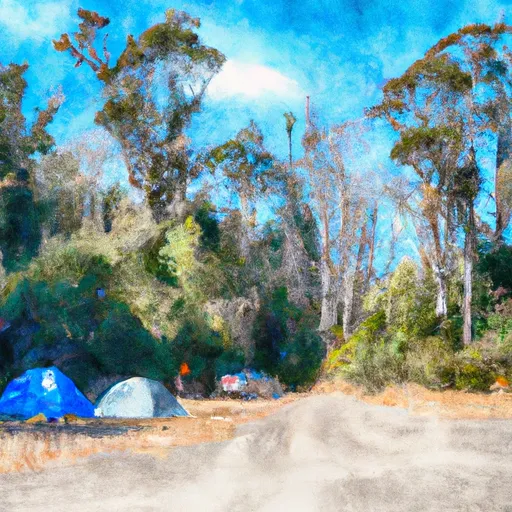
Viento State Park Campground
Community Reviews
Been here? Share the conditions.
Reviews, ratings & photos are added in the free Snoflo iOS app — rate a spot, tag the conditions, and your visit is verified by location. Add or manage your reviews from the app.
Viento State Park
The campground amenities at Viento State Park include 44 campsites for tents and RVs, restrooms, showers, and a dump station. The campsites are available on a first-come, first-serve basis, and reservations are not accepted. An interesting fact about Viento State Park is that it is located on the historic Columbia River Highway, which was once a major transportation route in the area.
The best time to visit Viento State Park is during the summer months, from June to September, when the weather is warm and dry, with an average temperature of around 80 degrees Fahrenheit. However, visitors can also enjoy the park during the spring and fall, when the weather is cooler, with an average temperature of around 60 degrees Fahrenheit.
In summary, Viento State Park offers a breathtaking camping experience with a range of recreational activities and nearby points of interest. With its stunning views, campground amenities, and interesting history, it is a must-visit destination for nature lovers and history buffs alike.
What's on-site at Viento State Park
Key facilities Snoflo tracks for this campground. Confirm with the operator before booking -- amenities can change seasonally.
Plan your trip down to the hour
Same weather feed Snoflo's iOS app uses -- updated continuously from NOAA / yr.no.
Next 5 days, hour by hour
Temperature line with weather symbols on top, snow + rain accumulation as columns, humidity as a dotted line.
5-day forecast table
Every 3 hours, broken out across temperature, snow, rain, humidity, and wind. Each cell is colour-coded relative to the column min/max so trends jump out at a glance.
| Time | Condition | Temp (°F) | Snow (in) | Rain (in) | Humidity (%) | Wind (mps) | Wind dir |
|---|---|---|---|---|---|---|---|
| Loading detailed forecast… | |||||||
15-day temperature & precipitation
Daily temperatures, snow, and rain projected over the next two weeks. Hover any point for the full breakdown.
Other campgrounds in the area
Snoflo-tracked campsites within driving distance of Viento State Park, with reservations status.
| Campground | Reservations | Toilets | View |
|---|---|---|---|
| Viento State Park North Campground | ✗ | ✗ | → |
| Wyeth - Columbia River Gorge Area | ✗ | ✓ | → |
| Wyeth Campground | ✗ | ✗ | → |
| Home Valley Campground | ✗ | ✗ | → |
| North Lake Campsite | ✗ | ✗ | → |
Nearby streamflow
USGS streamgauges within reach of Viento State Park -- pulled live from the National Water Information System.
| Streamgauge | Discharge | View |
|---|---|---|
| Hood River At Tucker Bridge | 234 cfs | → |
| White Salmon River Near Underwood | 527 cfs | → |
| Mosier Creek Near Mosier | 0 cfs | → |
| Bull Run River At Lower Flume Nr Brightwood | 20 cfs | → |
| Blazed Alder Creek Near Rhododendron | 3 cfs | → |
| Bull Run River Near Multnomah Falls | 51 cfs | → |
Nearby snow depths
NRCS SNOTEL stations within reach of Viento State Park -- relevant when planning a shoulder-season or alpine trip.
| SNOTEL station | Snowpack | 24h Snowfall | View |
|---|---|---|---|
| Greenpoint | 0.0 in | 0.0 in | → |
| Nohrsc Greenpoint | 0.0 in | 0.0 in | → |
| Hood River | 0.0 in | 0.0 in | → |
| Cascade Locks | 0.0 in | 0.0 in | → |
| Bonneville Dam | 0.0 in | 0.0 in | → |
| Red Hill | 0.0 in | 0.0 in | → |
Plan a longer trip
The closest parks, lakes, boat launches, and paddle runs so a camping night can grow into a full weekend.
Parks
- Viento State Park
- Gifford Pinchot National Forest
- Starvation Creek State Park
- Wygant State Natural Area
- Vincenz Lausmann Memorial State Natural Area
- Lindsey Creek State Scenic Corridor
Boat launches
- Drano Lake
- Kingsley Campground
- Lewis And Clark Trail Highway Skamania County
- Old Hatchery Road (Wind River)
- Port Of Hood River Marina Park
- Northwestern Park
Points of interest
- Dog Creek Falls Observation Site
- Western Antique Aeroplane & Automobile Museum
- Gallery At Columbia Center For The Arts
- Columbia River Gorge National Scenic Area
- Columbia River Highway Historic District
- Hood River Bridge
Paddle runs
- Hemlock Road Bridge To Gifford Pinchot Nf Boundary
- Confluence Clear And Coe Creeks To Mt. Hood Nf Boundary
- Headwaters In Sw1/4 Of Sec 13, T6n, R7e To Hemlock Road Bridge In Nw1/4 Of Sec 26, T4n, R7e
- Mt. Hood Wilderness Boundary To Confluence With Sandy River
- Sandy River
- Headwaters In Sw 1/4 Of Sec 8, T4n, R6e To Gifford Pinchot Nf Boundary
Camping essentials & Leave No Trace
- Pack it in, pack it out
- Take all trash, food scraps, and gear back with you to keep campsites clean and protect wildlife.
- Respect wildlife
- Observe animals from a distance, store food securely, and never feed wildlife to maintain natural behavior and safety.
- Know before you go
- Check weather, fire restrictions, trail conditions, and permit requirements to ensure a safe and well-planned trip.
- Minimize campfire impact
- Use established fire rings, keep fires small, fully extinguish them, or opt for a camp stove when fires are restricted.
- Leave what you find
- Preserve natural and cultural features by avoiding removal of plants, rocks, artifacts, or other elements of the environment.
Set push alerts in the Snoflo app
Save Viento State Park as a favorite, set a custom threshold (precipitation, snowpack, freezing temperatures), and the iOS app will push the moment conditions cross.
About Viento State Park
Can I make reservations at Viento State Park?
This campground does not appear to accept reservations -- it's typically first-come, first-served. Arrive early on summer weekends.
How fresh is the weather data on this page?
The hourly forecast updates throughout the day from the NOAA / yr.no public feeds. Streamflow data is pulled live from USGS streamgauges and snowpack from the NRCS SNOTEL network.
What's the best time of year to visit?
Use the 15-day temperature & precipitation outlook on this page to plan -- pick a window with comfortable temperatures and low precipitation. For longer trips, the 5-day hourly meteogram shows snow + rain accumulation hour-by-hour.
How do I get to Viento State Park?
Tap Directions in the hero above to open driving directions in Google Maps, or Open in map to center the Snoflo interactive map on the campground.
Can I get alerts when conditions change?
Yes -- alerts are managed through the Snoflo iOS app. Favorite this campground, set a threshold (temperature, snowpack, precipitation), and you'll get a push the moment it crosses.
Other campgrounds near here
Snoflo-tracked campgrounds within driving distance of Viento State Park.