Atherton Creek Campground
Community Reviews
Been here? Share the conditions.
Reviews, ratings & photos are added in the free Snoflo iOS app — rate a spot, tag the conditions, and your visit is verified by location. Add or manage your reviews from the app.
Atherton Creek
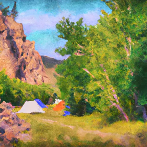
Reservations are accepted at Atherton Creek camping area, ensuring that campers can secure a spot ahead of time and avoid any inconvenience upon arrival. It is recommended to make reservations in advance, especially during the peak season, as the campground can quickly fill up due to its popularity.
The best time of year to visit Atherton Creek camping area is during the summer months when the weather is pleasant and conducive to outdoor activities. The campsite is situated in a charming forested area, offering shade during hot summer days. It's also worth noting that the campground can get crowded during weekends and holidays, so plan accordingly for a more peaceful experience.
In terms of specific items of interest, Atherton Creek camping area provides easy access to hiking trails, fishing spots, and other recreational activities. Its location amidst the natural beauty of Wyoming offers campers the opportunity to explore the stunning landscapes and wildlife of the region. However, visitors should be cautious of wildlife encounters, including bears, and should take necessary precautions to keep themselves and their food safe. Overall, Atherton Creek camping area is a fantastic destination for nature lovers seeking a peaceful camping experience in the heart of Wyoming.
What's on-site at Atherton Creek
Key facilities Snoflo tracks for this campground. Confirm with the operator before booking -- amenities can change seasonally.
Plan your trip down to the hour
Same weather feed Snoflo's iOS app uses -- updated continuously from NOAA / yr.no.
Next 5 days, hour by hour
Temperature line with weather symbols on top, snow + rain accumulation as columns, humidity as a dotted line.
5-day forecast table
Every 3 hours, broken out across temperature, snow, rain, humidity, and wind. Each cell is colour-coded relative to the column min/max so trends jump out at a glance.
| Time | Condition | Temp (°F) | Snow (in) | Rain (in) | Humidity (%) | Wind (mps) | Wind dir |
|---|---|---|---|---|---|---|---|
| Loading detailed forecast… | |||||||
15-day temperature & precipitation
Daily temperatures, snow, and rain projected over the next two weeks. Hover any point for the full breakdown.
Other campgrounds in the area
Snoflo-tracked campsites within driving distance of Atherton Creek, with reservations status.
| Campground | Reservations | Toilets | View |
|---|---|---|---|
| Atherton Creek Campground | ✓ | ✗ | → |
| Atherton Creek Campground (Usfs) | ✗ | ✗ | → |
| Red Hills | ✗ | ✓ | → |
| Red Hills Campground (Usfs) | ✗ | ✗ | → |
| Crystal Creek | ✗ | ✓ | → |
Nearby streamflow
USGS streamgauges within reach of Atherton Creek -- pulled live from the National Water Information System.
| Streamgauge | Discharge | View |
|---|---|---|
| Gros Ventre River At Kelly Wy | 404 cfs | → |
| Snake River At Moose | 6,190 cfs | → |
| Gros Ventre River At Zenith Wy | 149 cfs | → |
| Buffalo Fork Ab Lava Creek Nr Moran Wy | 619 cfs | → |
| Granite C Ab Granite C Supplemental | 57 cfs | → |
| Pacific Creek At Moran Wy | 81 cfs | → |
Nearby snow depths
NRCS SNOTEL stations within reach of Atherton Creek -- relevant when planning a shoulder-season or alpine trip.
| SNOTEL station | Snowpack | 24h Snowfall | View |
|---|---|---|---|
| Jackson 12.3 Ne | 0.0 in | 0.0 in | → |
| Moose - Coop | 0.0 in | 0.0 in | → |
| Surprise Meadow | 5.0 in | 0.0 in | → |
| Moran - Coop | 0.0 in | 0.0 in | → |
| Jackson - Coop | 0.0 in | 0.0 in | → |
| Granite Creek | 0.0 in | 0.0 in | → |
Plan a longer trip
The closest parks, lakes, boat launches, and paddle runs so a camping night can grow into a full weekend.
Parks
- Grand Teton National Park
- Wayne May Park
- Mike Yokel Park
- George Washington Memorial Park
- Phil Baux Park
- Mateosky Park
Boat launches
Fishing spots
- Jenny Lake
- Astoria Boating Site
- Jade Lakes
- Pritchard Boating Site
- Elbow Boating Site
- Palisades Reservoir
Points of interest
- Gap Puche Cabin
- Main Lodge
- Hunter-Hereford Ranch
- T. A. Moulton Barn
- Menors Ferry Historic District
- Albright View Turnout
Paddle runs
- Headwaters Of South And Roaring Forks And Mainstem To Confluence With South Fork
- 1st Gorge Lime
- Headwaters Of North And South Forks And Mainstem To Boundary Of Jedediah Smith Wilderness
- Granite Creek
- South Park Bridge To 1 Mile Downstream From Astoria Hot Springs (North Section Line Of Sec 5, T38n, R116w)
- Badger Creek
Camping essentials & Leave No Trace
- Pack it in, pack it out
- Take all trash, food scraps, and gear back with you to keep campsites clean and protect wildlife.
- Respect wildlife
- Observe animals from a distance, store food securely, and never feed wildlife to maintain natural behavior and safety.
- Know before you go
- Check weather, fire restrictions, trail conditions, and permit requirements to ensure a safe and well-planned trip.
- Minimize campfire impact
- Use established fire rings, keep fires small, fully extinguish them, or opt for a camp stove when fires are restricted.
- Leave what you find
- Preserve natural and cultural features by avoiding removal of plants, rocks, artifacts, or other elements of the environment.
Set push alerts in the Snoflo app
Save Atherton Creek as a favorite, set a custom threshold (precipitation, snowpack, freezing temperatures), and the iOS app will push the moment conditions cross.
About Atherton Creek
Can I make reservations at Atherton Creek?
This campground does not appear to accept reservations -- it's typically first-come, first-served. Arrive early on summer weekends.
How fresh is the weather data on this page?
The hourly forecast updates throughout the day from the NOAA / yr.no public feeds. Streamflow data is pulled live from USGS streamgauges and snowpack from the NRCS SNOTEL network.
What's the best time of year to visit?
Use the 15-day temperature & precipitation outlook on this page to plan -- pick a window with comfortable temperatures and low precipitation. For longer trips, the 5-day hourly meteogram shows snow + rain accumulation hour-by-hour.
How do I get to Atherton Creek?
Tap Directions in the hero above to open driving directions in Google Maps, or Open in map to center the Snoflo interactive map on the campground.
Can I get alerts when conditions change?
Yes -- alerts are managed through the Snoflo iOS app. Favorite this campground, set a threshold (temperature, snowpack, precipitation), and you'll get a push the moment it crosses.
Other campgrounds near here
Snoflo-tracked campgrounds within driving distance of Atherton Creek.