

-
 Snoflo Premium
Get unlimited access to all our content
With no Ad interruptions! - Start Your Free Trial Login with existing account
Wrightwood
Eden Index
Climate
9.3
•
Recreation
8.7
•
Community
1.3
•
Safeguard
7.1/10
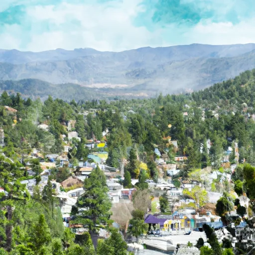
Wrightwood, California, located in the San Gabriel Mountains, offers residents and visitors an idyllic mountain environment with a diverse climate and abundant outdoor recreation opportunities.
The climate in Wrightwood is classified as a Mediterranean climate, characterized by hot, dry summers and cool, wet winters. Summers are comfortable with temperatures averaging in the 80s°F, while winters bring snowfall and cooler temperatures, usually in the 40s°F. The area's hydrology constituents consist of several creeks and springs, including Blue Ridge Spring and Lone Pine Creek, which provide a reliable water source to the region.
Outdoor enthusiasts have a multitude of recreational activities to enjoy in Wrightwood. The area is renowned for its skiing and snowboarding, with Mountain High Ski Resort offering excellent slopes and terrain for all skill levels. The San Gabriel Mountains also provide opportunities for hiking, mountain biking, and rock climbing, with scenic trails such as the Pacific Crest Trail and the Blue Ridge Trail offering breathtaking views.
In conclusion, Wrightwood, California, offers a pleasant Mediterranean climate, ample hydrology constituents, and a wide range of outdoor recreation opportunities, making it an ideal destination for nature lovers and adventure seekers.
What is the Eden Index?
The Snoflo Eden Index serves as a comprehensive rating system for regions, evaluating their desirability through a holistic assessment of climate health, outdoor recreation opportunities, and natural disaster risk, acknowledging the profound impact of these factors on livability and well-being.
Climate Health Indicator (CHI): 9.3
Wrightwood receives approximately
614mm of rain per year,
with humidity levels near 72%
and air temperatures averaging around
10°C.
Wrightwood has a plant hardyness factor of
8, meaning
plants and agriculture in this region tend to thrive here all year round.
By considering the ideal temperature range, reliable water supplies, clean air, and stable seasonal rain or snowpacks, the Climate Health Indicator (CHI) underscores the significance of a healthy climate as the foundation for quality living.
A healthy climate is paramount for ensuring a high quality of life and livability in a region, fostering both physical well-being and environmental harmony. This can be characterized by ideal temperatures, reliable access to water supplies, clean air, and consistent seasonal rain or snowpacks.
Weather Forecast
Streamflow Conditions
Northern Mojave
Area Rivers
Northern Mojave
Snowpack Depths
Northern Mojave
Reservoir Storage Capacity
Northern Mojave
Groundwater Levels
Recreational Opportunity Index (ROI): 8.7
The Recreational Opportunity Index (ROI) recognizes the value of outdoor recreational options, such as parks, hiking trails, camping sites, and fishing spots, while acknowledging that climate plays a pivotal role in ensuring the comfort and consistency of these experiences.
Access to outdoor recreational opportunities, encompassing activities such as parks, hiking, camping, and fishing, is crucial for overall well-being, and the climate plays a pivotal role in enabling and enhancing these experiences, ensuring that individuals can engage in nature-based activities comfortably and consistently.
Camping Areas
| Campground | Campsites | Reservations | Toilets | Showers | Elevation |
|---|---|---|---|---|---|
| Cabin Flat | 11 | 6,690 ft | |||
| Chino Hills - State Park | 20 | 480 ft | |||
| Prado Regional Park | 75 | 553 ft | |||
| Applewhite | 44 | 3,306 ft | |||
| Crystal Lake Rec Area | 191 | 5,689 ft | |||
| Manker | 21 | 6,015 ft | |||
| Coldbrook | 20 | 3,285 ft | |||
| Lupine | 11 | 6,551 ft | |||
| Rancho Jurupa Park | 67 | 751 ft | |||
| Bohelli Regional Park | None | 1,107 ft |
Nearby Ski Areas
Catastrophe Safeguard Index (CSI):
The Catastrophe Safeguard Index (CSI) recognizes that natural disaster risk, encompassing floods, fires, hurricanes, and tornadoes, can drastically affect safety and the overall appeal of an area.
The level of natural disaster risk in a region significantly affects safety and the overall livability, with climate change amplifying these risks by potentially increasing the frequency and intensity of events like floods, fires, hurricanes, and tornadoes, thereby posing substantial challenges to community resilience and well-being.
Community Resilience Indicator (CRI): 1.3
The Community Resilience Indicator (CRI) recognizes that education, healthcare, and socioeconomics are crucial to the well-being of a region. The CRI acknowledges the profound impact of these elements on residents' overall quality of life. By evaluating educational resources, healthcare accessibility, and economic inclusivity, the index captures the essential aspects that contribute to a thriving community, fostering resident satisfaction, equity, and social cohesion.