Bishop Creek River Run
Community Reviews
Been here? Share the conditions.
Reviews, ratings & photos are added in the free Snoflo iOS app — rate a spot, tag the conditions, and your visit is verified by location. Add or manage your reviews from the app.
Bishop Creek
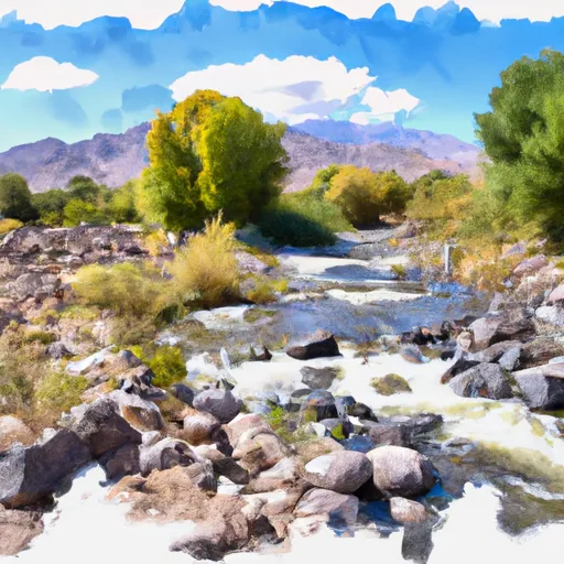
Some of the specific river rapids and obstacles to watch out for on Bishop Creek include the "Bishop's Crack" and "Crucible" rapids, which are both technical and challenging sections that require skill and precision to navigate. The river also has several boulder gardens and steep drops, adding to the excitement and challenge of the run.
There are specific regulations to follow when visiting Bishop Creek, including obtaining the appropriate permits and adhering to Leave No Trace principles. The area is also subject to seasonal restrictions and closures, so it is important to check with the local ranger station for current information before planning a trip.
Overall, Bishop Creek is a thrilling whitewater run that offers a combination of technical rapids, challenging obstacles, and stunning scenery. It is important to come prepared with the right gear, experience, and knowledge of the area to ensure a safe and enjoyable adventure.
Plan your run down to the hour
Same weather feed Snoflo's iOS app uses -- updated continuously from NOAA / yr.no. Watch the precipitation column on the meteogram; rain ahead of a run typically lifts flows 12-48 hours later depending on the basin.
Next 5 days, hour by hour
Temperature line with weather symbols on top, snow + rain accumulation as columns, humidity as a dotted line.
5-day forecast table
Every 3 hours, broken out across temperature, snow, rain, humidity, and wind. Each cell is colour-coded relative to the column min/max.
| Time | Condition | Temp (°F) | Snow (in) | Rain (in) | Humidity (%) | Wind (mps) | Wind dir |
|---|---|---|---|---|---|---|---|
| Loading detailed forecast… | |||||||
15-day temperature & precipitation
Daily temperatures, snow, and rain projected over the next two weeks -- the upstream story that drives next week's flows.
Regional streamflow levels
USGS streamgauges around Bishop Creek -- useful for spotting upstream pulses and gauging which tributary is contributing what.
| Streamgauge | Discharge | View |
|---|---|---|
| Agua Fria River Near Mayer | 14 cfs | → |
| Wet Bottom Creek Near Childs | 1 cfs | → |
| Verde River Near Camp Verde | 67 cfs | → |
| Agua Fria River Near Rock Springs | · | → |
| Verde R Blw Tangle Creek | 165 cfs | → |
| New River Near Rock Springs | · | → |
Plan a longer trip
The closest boat launches, other paddle runs, and campgrounds so a day on the water can grow into a full weekend.
Campgrounds
- Agua Fria National Monument
- Agua Fria National Monument Dispersed
- Kentuck Springs
- Kentuck Spring Campground
- Childs
- Childs Dispersed Camping Area
Fishing spots
- Horsethief Boating Site / Day Use Area
- Horsethief Lake
- North Canyon Creek
- West Clear Creek
- Deadman Creek
- South Fork Deadman Creek
Whitewater safety
- Check the flow before you run
- Use the linked-gauge card and Regional Flow panel above. Class ratings change with flow -- a Class III at low water can become Class IV+ at high water.
- Know your skill ceiling
- Pick runs comfortably below your ceiling. Cold-water and big-water runs raise the consequences of any mistake.
- Wear the right gear
- Helmet, PFD, drysuit / wetsuit when water is below 60°F. Throw bag, knife, and whistle on your person, not in the boat.
- Scout, set safety, and run with a team
- Scout new rapids on foot, set safety with throw bags above the consequence pool, and run with at least one other competent paddler.
- Respect the river
- Strainers, undercuts, low-head dams, and wood can kill at any class rating. When in doubt, portage.
Set push alerts in the Snoflo app
Save Bishop Creek as a favorite, set a discharge threshold (e.g. "alert me when flow hits 600 cfs"), and the iOS app pushes the moment the linked gauge crosses.
About Bishop Creek
What's the optimal flow for Bishop Creek?
The optimal flow depends on the section and the craft. Check the Run Details panel for the linked gauge and current status.
How fresh is the cfs reading on this page?
The linked USGS streamgauge reports continuously (every 15 minutes); Snoflo refreshes throughout the day. Hover the streamflow sparkline to read individual datapoints.
What's the whitewater class?
See the Run Details panel for the class rating Snoflo tracks for this run. Class ratings change with flow -- a Class III at low water can become Class IV in high water.
Where do I put in / take out?
Tap Directions in the hero above to open driving directions to the put-in. For shuttle planning, check the Nearby Boat Launches panel and the river run operator's site.
Can I get alerts when flows hit the optimal range?
Yes -- alerts are managed in the Snoflo iOS app. Favorite this run, set a discharge threshold, and you'll get a push the moment the gauge crosses.
Other runs near here
Snoflo-tracked paddle runs within driving distance of Bishop Creek.