Headwaters To Confluence With New River river run
Community Reviews
Been here? Share the conditions.
Reviews, ratings & photos are added in the free Snoflo iOS app — rate a spot, tag the conditions, and your visit is verified by location. Add or manage your reviews from the app.
Headwaters To Confluence With New River
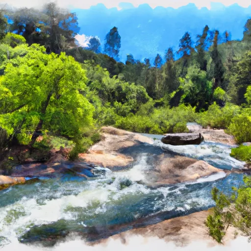
The segment mileage for the Whitewater River Run from Headwaters to Confluence With New River is approximately 12 miles. This section of the river features several thrilling rapids and obstacles, including the "Bloody Mary" rapid, "Goat Trail" rapid, and "Surprise" rapid. These rapids offer a fun and challenging experience for experienced rafters.
There are specific regulations to the area that should be followed, including wearing proper safety gear such as helmets and life jackets, and avoiding alcohol consumption before and during the river run. It is also important to follow Leave No Trace principles and pack out all trash and waste.
Overall, the Whitewater River Run from Headwaters to Confluence With New River in California offers a thrilling and exciting experience for intermediate and advanced river rafters. It is important to follow safety regulations and respect the environment to ensure a safe and sustainable experience for all.
Plan your run down to the hour
Same weather feed Snoflo's iOS app uses -- updated continuously from NOAA / yr.no. Watch the precipitation column on the meteogram; rain ahead of a run typically lifts flows 12-48 hours later depending on the basin.
Next 5 days, hour by hour
Temperature line with weather symbols on top, snow + rain accumulation as columns, humidity as a dotted line.
5-day forecast table
Every 3 hours, broken out across temperature, snow, rain, humidity, and wind. Each cell is colour-coded relative to the column min/max.
| Time | Condition | Temp (°F) | Snow (in) | Rain (in) | Humidity (%) | Wind (mps) | Wind dir |
|---|---|---|---|---|---|---|---|
| Loading detailed forecast… | |||||||
15-day temperature & precipitation
Daily temperatures, snow, and rain projected over the next two weeks -- the upstream story that drives next week's flows.
Regional streamflow levels
USGS streamgauges around Headwaters To Confluence With New River -- useful for spotting upstream pulses and gauging which tributary is contributing what.
| Streamgauge | Discharge | View |
|---|---|---|
| Klamath R A Orleans | 1,110 cfs | → |
| Salmon R A Somes Bar Ca | 277 cfs | → |
| Trinity R A Hoopa Ca | 747 cfs | → |
| Trinity R Nr Burnt Ranch Ca | 575 cfs | → |
| Nf Trinity R A Helena Ca | 47 cfs | → |
| Redwood C Nr Blue Lake Ca | 8 cfs | → |
Plan a longer trip
The closest boat launches, other paddle runs, and campgrounds so a day on the water can grow into a full weekend.
Boat launches
- Methodist Creek River Access
- Matthews Creek River Access
- Nordheimer Flat River Access
- Saw Pit Flat River Access
- Bloomer Falls River Access
- Red Bank River Access
Other river runs
- Headwaters In Sw 1/4, Sec 24, T8n, R12w To Trinity Wsr (At Hobo Gulch Trailhead And Campground)
- Confluence With Blind Horse Creek To Cecilville Bridge
- Confluence With Sixmile Creek To Confluence With South Fork Salmon River
- Confluence Of Tributaries In Sec 6 Near Black Mtn. To Confluence With Blind Horse Creek
- Scott District Boundary To Confluence With Sixmile Creek
Campgrounds
Fishing spots
Parks
Whitewater safety
- Check the flow before you run
- Use the linked-gauge card and Regional Flow panel above. Class ratings change with flow -- a Class III at low water can become Class IV+ at high water.
- Know your skill ceiling
- Pick runs comfortably below your ceiling. Cold-water and big-water runs raise the consequences of any mistake.
- Wear the right gear
- Helmet, PFD, drysuit / wetsuit when water is below 60°F. Throw bag, knife, and whistle on your person, not in the boat.
- Scout, set safety, and run with a team
- Scout new rapids on foot, set safety with throw bags above the consequence pool, and run with at least one other competent paddler.
- Respect the river
- Strainers, undercuts, low-head dams, and wood can kill at any class rating. When in doubt, portage.
Set push alerts in the Snoflo app
Save Headwaters To Confluence With New River as a favorite, set a discharge threshold (e.g. "alert me when flow hits 600 cfs"), and the iOS app pushes the moment the linked gauge crosses.
About Headwaters To Confluence With New River
What's the optimal flow for Headwaters To Confluence With New River?
The optimal flow depends on the section and the craft. Check the Run Details panel for the linked gauge and current status.
How fresh is the cfs reading on this page?
The linked USGS streamgauge reports continuously (every 15 minutes); Snoflo refreshes throughout the day. Hover the streamflow sparkline to read individual datapoints.
What's the whitewater class?
See the Run Details panel for the class rating Snoflo tracks for this run. Class ratings change with flow -- a Class III at low water can become Class IV in high water.
Where do I put in / take out?
Tap Directions in the hero above to open driving directions to the put-in. For shuttle planning, check the Nearby Boat Launches panel and the river run operator's site.
Can I get alerts when flows hit the optimal range?
Yes -- alerts are managed in the Snoflo iOS app. Favorite this run, set a discharge threshold, and you'll get a push the moment the gauge crosses.
Other runs near here
Snoflo-tracked paddle runs within driving distance of Headwaters To Confluence With New River.