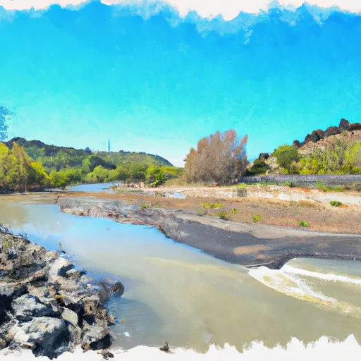
Cosumnes Mine Road To Confluence With Steely Fork Cosumnes River River Run
Community Reviews
Been here? Share the conditions.
Reviews, ratings & photos are added in the free Snoflo iOS app — rate a spot, tag the conditions, and your visit is verified by location. Add or manage your reviews from the app.
Cosumnes Mine Road To Confluence With Steely Fork Cosumnes River
Some of the notable rapids and obstacles on this section of the river include Meatgrinder, Troublemaker, and the infamous Swimmer's Rapid, which requires expert navigation skills. It is important to note that this section of the river is recommended for experienced whitewater kayakers and rafters only.
There are specific regulations to the area, including a mandatory vehicle shuttle and camping permit. Additionally, visitors must follow Leave No Trace principles and pack out all trash and waste. It is also important to be aware of the various private landowners along the river and to respect their property and privacy.
Overall, the Cosumnes River run from Cosumnes Mine Road to the confluence with Steely Fork offers a thrilling and challenging whitewater experience for experienced paddlers. However, proper preparation and adherence to regulations are essential for a safe and enjoyable trip.
Plan your run down to the hour
Same weather feed Snoflo's iOS app uses -- updated continuously from NOAA / yr.no. Watch the precipitation column on the meteogram; rain ahead of a run typically lifts flows 12-48 hours later depending on the basin.
Next 5 days, hour by hour
Temperature line with weather symbols on top, snow + rain accumulation as columns, humidity as a dotted line.
5-day forecast table
Every 3 hours, broken out across temperature, snow, rain, humidity, and wind. Each cell is colour-coded relative to the column min/max.
| Time | Condition | Temp (°F) | Snow (in) | Rain (in) | Humidity (%) | Wind (mps) | Wind dir |
|---|---|---|---|---|---|---|---|
| Loading detailed forecast… | |||||||
15-day temperature & precipitation
Daily temperatures, snow, and rain projected over the next two weeks -- the upstream story that drives next week's flows.
Regional streamflow levels
USGS streamgauges around Cosumnes Mine Road To Confluence With Steely Fork Cosumnes River -- useful for spotting upstream pulses and gauging which tributary is contributing what.
| Streamgauge | Discharge | View |
|---|---|---|
| Pilot C Ab Stumpy Meadows Res Ca | 3 cfs | → |
| Pilot C Bl Mutton Canyon Nr Georgetown Ca | 2 cfs | → |
| Deer C Nr Cameron Park Ca | 8 cfs | → |
| Upper Truckee R At S Upper Truckee Rd Nr Meyers Ca | 4 cfs | → |
| Upper Truckee R At Hwy 50 Above Meyers Ca | 11 cfs | → |
| Cosumnes R A Michigan Bar Ca | 50 cfs | → |
Plan a longer trip
The closest boat launches, other paddle runs, and campgrounds so a day on the water can grow into a full weekend.
Boat launches
- Sly Park Road, Pollock Pines
- Jenkinson Lake - Stonebreaker Camp
- Forebay Road El Dorado County
- Poho Ridge El Dorado County
- Junction Boat Ramp Road El Dorado County
- Ice House Reservoir
Other river runs
- Confluence With Van Horn Creek To Cosumnes Mine Road
- Confluence With Dogtown Creek To West Nf Boundary
- Two Miles West Of Pipi Campground To Confluence With Dogtown Creek
- One Mile East Of Pipi Campground To Two Miles West Of Pipi Campground
- Confluence With Cat Creek To One Mile East Of Pipi Campground
Campgrounds
- Teepee Point
- Pine Cone - Sly Park Recreation Area
- Sly Park
- Cowboy Camp
- Wilderness Outpost Camp
- Frontier Adventure
Fishing spots
- Ice House Reservoir
- Union Valley Reservoir
- Stumpy Meadows Lake
- Lower Bear River Reservoir
- Bear River Reservoir
- Wrights Lake
Parks
Whitewater safety
- Check the flow before you run
- Use the linked-gauge card and Regional Flow panel above. Class ratings change with flow -- a Class III at low water can become Class IV+ at high water.
- Know your skill ceiling
- Pick runs comfortably below your ceiling. Cold-water and big-water runs raise the consequences of any mistake.
- Wear the right gear
- Helmet, PFD, drysuit / wetsuit when water is below 60°F. Throw bag, knife, and whistle on your person, not in the boat.
- Scout, set safety, and run with a team
- Scout new rapids on foot, set safety with throw bags above the consequence pool, and run with at least one other competent paddler.
- Respect the river
- Strainers, undercuts, low-head dams, and wood can kill at any class rating. When in doubt, portage.
Set push alerts in the Snoflo app
Save Cosumnes Mine Road To Confluence With Steely Fork Cosumnes River as a favorite, set a discharge threshold (e.g. "alert me when flow hits 600 cfs"), and the iOS app pushes the moment the linked gauge crosses.
About Cosumnes Mine Road To Confluence With Steely Fork Cosumnes River
What's the optimal flow for Cosumnes Mine Road To Confluence With Steely Fork Cosumnes River?
The optimal flow depends on the section and the craft. Check the Run Details panel for the linked gauge and current status.
How fresh is the cfs reading on this page?
The linked USGS streamgauge reports continuously (every 15 minutes); Snoflo refreshes throughout the day. Hover the streamflow sparkline to read individual datapoints.
What's the whitewater class?
See the Run Details panel for the class rating Snoflo tracks for this run. Class ratings change with flow -- a Class III at low water can become Class IV in high water.
Where do I put in / take out?
Tap Directions in the hero above to open driving directions to the put-in. For shuttle planning, check the Nearby Boat Launches panel and the river run operator's site.
Can I get alerts when flows hit the optimal range?
Yes -- alerts are managed in the Snoflo iOS app. Favorite this run, set a discharge threshold, and you'll get a push the moment the gauge crosses.
Other runs near here
Snoflo-tracked paddle runs within driving distance of Cosumnes Mine Road To Confluence With Steely Fork Cosumnes River.