One Mile East Of Pipi Campground To Two Miles West Of Pipi Campground River Run
Community Reviews
Been here? Share the conditions.
Reviews, ratings & photos are added in the free Snoflo iOS app — rate a spot, tag the conditions, and your visit is verified by location. Add or manage your reviews from the app.
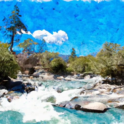
One Mile East Of Pipi Campground To Two Miles West Of Pipi Campground
The specific rapids and obstacles in this section of the river include “The Maze,” “Pinball,” and “Rockpile,” which are all Class IV rapids that demand technical skills and fast reaction times. The “Blender” is another notable rapid in this section, which is a Class III rapid that features a large eddy that can trap kayakers and rafts.
There are specific regulations in place for this section of the river. All boaters are required to have a valid California Boater Card, and children under 13 years old must wear a properly fitting life jacket at all times. Additionally, boaters must adhere to all state and federal laws, including those related to littering, alcohol use, and river access.
Overall, the One Mile East of Pipi Campground to Two Miles West of Pipi Campground section of the Whitewater River in California offers a challenging and exciting whitewater rafting experience for experienced boaters. It is important to follow all regulations and safety precautions to ensure a safe and enjoyable trip.
Plan your run down to the hour
Same weather feed Snoflo's iOS app uses -- updated continuously from NOAA / yr.no. Watch the precipitation column on the meteogram; rain ahead of a run typically lifts flows 12-48 hours later depending on the basin.
Next 5 days, hour by hour
Temperature line with weather symbols on top, snow + rain accumulation as columns, humidity as a dotted line.
5-day forecast table
Every 3 hours, broken out across temperature, snow, rain, humidity, and wind. Each cell is colour-coded relative to the column min/max.
| Time | Condition | Temp (°F) | Snow (in) | Rain (in) | Humidity (%) | Wind (mps) | Wind dir |
|---|---|---|---|---|---|---|---|
| Loading detailed forecast… | |||||||
15-day temperature & precipitation
Daily temperatures, snow, and rain projected over the next two weeks -- the upstream story that drives next week's flows.
Regional streamflow levels
USGS streamgauges around One Mile East Of Pipi Campground To Two Miles West Of Pipi Campground -- useful for spotting upstream pulses and gauging which tributary is contributing what.
| Streamgauge | Discharge | View |
|---|---|---|
| Pilot C Ab Stumpy Meadows Res Ca | 3 cfs | → |
| Upper Truckee R At S Upper Truckee Rd Nr Meyers Ca | 4 cfs | → |
| Pilot C Bl Mutton Canyon Nr Georgetown Ca | 2 cfs | → |
| Upper Truckee R At Hwy 50 Above Meyers Ca | 12 cfs | → |
| Deer C Nr Cameron Park Ca | 8 cfs | → |
| Up Truckee R A South Lake Tahoe Ca | 9 cfs | → |
Plan a longer trip
The closest boat launches, other paddle runs, and campgrounds so a day on the water can grow into a full weekend.
Boat launches
- Bear River Lake Resort
- Jenkinson Lake - Stonebreaker Camp
- Sly Park Road, Pollock Pines
- Amador County
- Silver Lake
- Kit Carson Resort
Other river runs
- Two Miles West Of Pipi Campground To Confluence With Dogtown Creek
- Confluence With Cat Creek To One Mile East Of Pipi Campground
- Confluence With Van Horn Creek To Cosumnes Mine Road
- Boundary Of Mokelumne Archeological Special Interest Area To Confluence With North Fork Mokelumne
- Confluence With Dogtown Creek To West Nf Boundary
Campgrounds
Fishing spots
- Lower Bear River Reservoir
- Bear River Reservoir
- Salt Springs Reservoir
- Silver Lake (Kirkwood)
- Ice House Reservoir
- Lake Tabeaud
Parks
Whitewater safety
- Check the flow before you run
- Use the linked-gauge card and Regional Flow panel above. Class ratings change with flow -- a Class III at low water can become Class IV+ at high water.
- Know your skill ceiling
- Pick runs comfortably below your ceiling. Cold-water and big-water runs raise the consequences of any mistake.
- Wear the right gear
- Helmet, PFD, drysuit / wetsuit when water is below 60°F. Throw bag, knife, and whistle on your person, not in the boat.
- Scout, set safety, and run with a team
- Scout new rapids on foot, set safety with throw bags above the consequence pool, and run with at least one other competent paddler.
- Respect the river
- Strainers, undercuts, low-head dams, and wood can kill at any class rating. When in doubt, portage.
Set push alerts in the Snoflo app
Save One Mile East Of Pipi Campground To Two Miles West Of Pipi Campground as a favorite, set a discharge threshold (e.g. "alert me when flow hits 600 cfs"), and the iOS app pushes the moment the linked gauge crosses.
About One Mile East Of Pipi Campground To Two Miles West Of Pipi Campground
What's the optimal flow for One Mile East Of Pipi Campground To Two Miles West Of Pipi Campground?
The optimal flow depends on the section and the craft. Check the Run Details panel for the linked gauge and current status.
How fresh is the cfs reading on this page?
The linked USGS streamgauge reports continuously (every 15 minutes); Snoflo refreshes throughout the day. Hover the streamflow sparkline to read individual datapoints.
What's the whitewater class?
See the Run Details panel for the class rating Snoflo tracks for this run. Class ratings change with flow -- a Class III at low water can become Class IV in high water.
Where do I put in / take out?
Tap Directions in the hero above to open driving directions to the put-in. For shuttle planning, check the Nearby Boat Launches panel and the river run operator's site.
Can I get alerts when flows hit the optimal range?
Yes -- alerts are managed in the Snoflo iOS app. Favorite this run, set a discharge threshold, and you'll get a push the moment the gauge crosses.
Other runs near here
Snoflo-tracked paddle runs within driving distance of One Mile East Of Pipi Campground To Two Miles West Of Pipi Campground.