White Rock Creek Trib River Run
Community Reviews
Been here? Share the conditions.
Reviews, ratings & photos are added in the free Snoflo iOS app — rate a spot, tag the conditions, and your visit is verified by location. Add or manage your reviews from the app.
White Rock Creek Trib
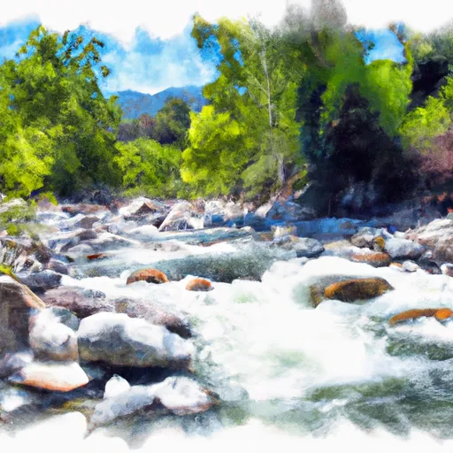
One of the most challenging sections of the White Rock Creek Tributary is the Class IV "S-Turn" rapid, which features tight turns and steep drops. Other notable rapids include "The Maze" and "The Chute," both of which require precise maneuvering through narrow channels.
It is important to note that the White Rock Creek Tributary is located on private property and is only open to the public during specific times of the year. Additionally, all boaters must have a valid permit from the landowner to access the river. It is also recommended for all boaters to wear proper safety gear, including helmets and life jackets, due to the technical nature of the rapids.
Overall, the White Rock Creek Tributary is a challenging and exciting whitewater run that requires skill and experience to navigate. Boaters should be aware of the specific regulations and safety precautions before attempting to traverse its rapids.
Plan your run down to the hour
Same weather feed Snoflo's iOS app uses -- updated continuously from NOAA / yr.no. Watch the precipitation column on the meteogram; rain ahead of a run typically lifts flows 12-48 hours later depending on the basin.
Next 5 days, hour by hour
Temperature line with weather symbols on top, snow + rain accumulation as columns, humidity as a dotted line.
5-day forecast table
Every 3 hours, broken out across temperature, snow, rain, humidity, and wind. Each cell is colour-coded relative to the column min/max.
| Time | Condition | Temp (°F) | Snow (in) | Rain (in) | Humidity (%) | Wind (mps) | Wind dir |
|---|---|---|---|---|---|---|---|
| Loading detailed forecast… | |||||||
15-day temperature & precipitation
Daily temperatures, snow, and rain projected over the next two weeks -- the upstream story that drives next week's flows.
Regional streamflow levels
USGS streamgauges around White Rock Creek Trib -- useful for spotting upstream pulses and gauging which tributary is contributing what.
| Streamgauge | Discharge | View |
|---|---|---|
| Elder C Nr Branscomb Ca | 1 cfs | → |
| Mf Eel R Nr Dos Rios Ca | 29 cfs | → |
| Sf Eel R A Leggett Ca | 29 cfs | → |
| Willits C Ab Lk Emily Nr Willits Ca | 0 cfs | → |
| Outlet C Nr Willits Ca | 4 cfs | → |
| Noyo R Nr Fort Bragg Ca | 11 cfs | → |
Plan a longer trip
The closest boat launches, other paddle runs, and campgrounds so a day on the water can grow into a full weekend.
Other river runs
Campgrounds
- Hiker-Biker Campsite - Standish-Hickey
- Redwoods River Resort Campground
- Abalone Point Campground
- Westport Beach Rv Park And Campground
Whitewater safety
- Check the flow before you run
- Use the linked-gauge card and Regional Flow panel above. Class ratings change with flow -- a Class III at low water can become Class IV+ at high water.
- Know your skill ceiling
- Pick runs comfortably below your ceiling. Cold-water and big-water runs raise the consequences of any mistake.
- Wear the right gear
- Helmet, PFD, drysuit / wetsuit when water is below 60°F. Throw bag, knife, and whistle on your person, not in the boat.
- Scout, set safety, and run with a team
- Scout new rapids on foot, set safety with throw bags above the consequence pool, and run with at least one other competent paddler.
- Respect the river
- Strainers, undercuts, low-head dams, and wood can kill at any class rating. When in doubt, portage.
Set push alerts in the Snoflo app
Save White Rock Creek Trib as a favorite, set a discharge threshold (e.g. "alert me when flow hits 600 cfs"), and the iOS app pushes the moment the linked gauge crosses.
About White Rock Creek Trib
What's the optimal flow for White Rock Creek Trib?
The optimal flow depends on the section and the craft. Check the Run Details panel for the linked gauge and current status.
How fresh is the cfs reading on this page?
The linked USGS streamgauge reports continuously (every 15 minutes); Snoflo refreshes throughout the day. Hover the streamflow sparkline to read individual datapoints.
What's the whitewater class?
See the Run Details panel for the class rating Snoflo tracks for this run. Class ratings change with flow -- a Class III at low water can become Class IV in high water.
Where do I put in / take out?
Tap Directions in the hero above to open driving directions to the put-in. For shuttle planning, check the Nearby Boat Launches panel and the river run operator's site.
Can I get alerts when flows hit the optimal range?
Yes -- alerts are managed in the Snoflo iOS app. Favorite this run, set a discharge threshold, and you'll get a push the moment the gauge crosses.
Other runs near here
Snoflo-tracked paddle runs within driving distance of White Rock Creek Trib.