Virginia Creek river run
Community Reviews
Been here? Share the conditions.
Reviews, ratings & photos are added in the free Snoflo iOS app — rate a spot, tag the conditions, and your visit is verified by location. Add or manage your reviews from the app.
Virginia Creek
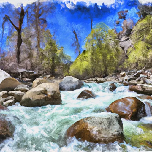
The river is known for its technical rapids and obstacles, including Pinball, a boulder-strewn rapid that requires precise maneuvering, and Boulder Sluice, a steep and narrow chute that requires expert navigation. The river also includes several other challenging rapids, including Squeeze Play and Leap of Faith.
To ensure the safety and preservation of the area, there are several regulations in place for the Virginia Creek run. All visitors must obtain a permit from the Bureau of Land Management before accessing the river. Visitors are also required to follow strict Leave No Trace principles and pack out all trash. Additionally, camping is only permitted in designated areas and fires are prohibited.
Overall, the Virginia Creek run is a challenging and exciting river for experienced whitewater enthusiasts. It is important to follow all regulations and safety guidelines to ensure the preservation of the area and the safety of all visitors.
Plan your run down to the hour
Same weather feed Snoflo's iOS app uses -- updated continuously from NOAA / yr.no. Watch the precipitation column on the meteogram; rain ahead of a run typically lifts flows 12-48 hours later depending on the basin.
Next 5 days, hour by hour
Temperature line with weather symbols on top, snow + rain accumulation as columns, humidity as a dotted line.
5-day forecast table
Every 3 hours, broken out across temperature, snow, rain, humidity, and wind. Each cell is colour-coded relative to the column min/max.
| Time | Condition | Temp (°F) | Snow (in) | Rain (in) | Humidity (%) | Wind (mps) | Wind dir |
|---|---|---|---|---|---|---|---|
| Loading detailed forecast… | |||||||
15-day temperature & precipitation
Daily temperatures, snow, and rain projected over the next two weeks -- the upstream story that drives next week's flows.
Regional streamflow levels
USGS streamgauges around Virginia Creek -- useful for spotting upstream pulses and gauging which tributary is contributing what.
| Streamgauge | Discharge | View |
|---|---|---|
| Green Creek Near Bridgeport | 25 cfs | → |
| Robinson C At Twin Lks Outlet Nr Bridgeport | 100 cfs | → |
| Buckeye C Nr Bridgeport | 41 cfs | → |
| E Walker R Nr Bridgeport | 178 cfs | → |
| E Walker R Blw Sweetwater C Nr Bridgeport | 22 cfs | → |
| W Walker R Blw L Walker R Nr Coleville | 153 cfs | → |
Plan a longer trip
The closest boat launches, other paddle runs, and campgrounds so a day on the water can grow into a full weekend.
Boat launches
- Paradise Shore Rv Park
- Lundy Lake
- Ramp Road Mono County
- Annett's Mono Village Fishing Resort
- Lee Vining Creek
- Navy Beach Paddle Boat Launch
Other river runs
- Green Creek
- Dog Creek
- Hoover Wilderness Boundary To Humboldt-Toiyabe National Forest Boundary
- Rough Creek
Campgrounds
Fishing spots
Whitewater safety
- Check the flow before you run
- Use the linked-gauge card and Regional Flow panel above. Class ratings change with flow -- a Class III at low water can become Class IV+ at high water.
- Know your skill ceiling
- Pick runs comfortably below your ceiling. Cold-water and big-water runs raise the consequences of any mistake.
- Wear the right gear
- Helmet, PFD, drysuit / wetsuit when water is below 60°F. Throw bag, knife, and whistle on your person, not in the boat.
- Scout, set safety, and run with a team
- Scout new rapids on foot, set safety with throw bags above the consequence pool, and run with at least one other competent paddler.
- Respect the river
- Strainers, undercuts, low-head dams, and wood can kill at any class rating. When in doubt, portage.
Set push alerts in the Snoflo app
Save Virginia Creek as a favorite, set a discharge threshold (e.g. "alert me when flow hits 600 cfs"), and the iOS app pushes the moment the linked gauge crosses.
About Virginia Creek
What's the optimal flow for Virginia Creek?
The optimal flow depends on the section and the craft. Check the Run Details panel for the linked gauge and current status.
How fresh is the cfs reading on this page?
The linked USGS streamgauge reports continuously (every 15 minutes); Snoflo refreshes throughout the day. Hover the streamflow sparkline to read individual datapoints.
What's the whitewater class?
See the Run Details panel for the class rating Snoflo tracks for this run. Class ratings change with flow -- a Class III at low water can become Class IV in high water.
Where do I put in / take out?
Tap Directions in the hero above to open driving directions to the put-in. For shuttle planning, check the Nearby Boat Launches panel and the river run operator's site.
Can I get alerts when flows hit the optimal range?
Yes -- alerts are managed in the Snoflo iOS app. Favorite this run, set a discharge threshold, and you'll get a push the moment the gauge crosses.
Other runs near here
Snoflo-tracked paddle runs within driving distance of Virginia Creek.