The Southern Boundary Of The Black Canyon Gunnison National Monument To The Painted Wall River Run
Community Reviews
Been here? Share the conditions.
Reviews, ratings & photos are added in the free Snoflo iOS app — rate a spot, tag the conditions, and your visit is verified by location. Add or manage your reviews from the app.
The Southern Boundary Of The Black Canyon Gunnison National Monument To The Painted Wall
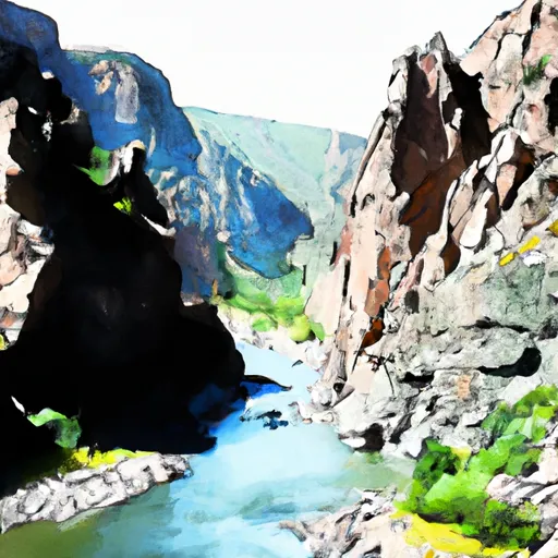
There are specific rapids and obstacles on the Whitewater River Run that are worth noting. One of the most notable features is the Black Canyon, which is a narrow, steep-walled canyon that offers stunning views. Other rapids include the Seidel's Suckhole, the Funnel, and the S.O.B. Rapid. These rapids are challenging and require skill and experience to navigate.
To ensure the safety of all visitors, there are specific regulations in place for the Whitewater River Run. All visitors are required to wear personal flotation devices (PFDs) at all times while on the river. There are also regulations in place regarding group size, camping, and littering. Visitors should be aware of these regulations and follow them to ensure the safety and preservation of the area.
In conclusion, the Whitewater River Run in Colorado offers a thrilling and challenging experience for experienced kayakers and rafters. With its ideal streamflow range, class rating, specific river rapids/obstacles, and regulations in place, visitors can enjoy this scenic river run while maintaining their safety and respecting the environment.
Plan your run down to the hour
Same weather feed Snoflo's iOS app uses -- updated continuously from NOAA / yr.no. Watch the precipitation column on the meteogram; rain ahead of a run typically lifts flows 12-48 hours later depending on the basin.
Next 5 days, hour by hour
Temperature line with weather symbols on top, snow + rain accumulation as columns, humidity as a dotted line.
5-day forecast table
Every 3 hours, broken out across temperature, snow, rain, humidity, and wind. Each cell is colour-coded relative to the column min/max.
| Time | Condition | Temp (°F) | Snow (in) | Rain (in) | Humidity (%) | Wind (mps) | Wind dir |
|---|---|---|---|---|---|---|---|
| Loading detailed forecast… | |||||||
15-day temperature & precipitation
Daily temperatures, snow, and rain projected over the next two weeks -- the upstream story that drives next week's flows.
Regional streamflow levels
USGS streamgauges around The Southern Boundary Of The Black Canyon Gunnison National Monument To The Painted Wall -- useful for spotting upstream pulses and gauging which tributary is contributing what.
| Streamgauge | Discharge | View |
|---|---|---|
| Gunnison River Below Gunnison Tunnel | 261 cfs | → |
| Cimarron River Bl Squaw Creek | 13 cfs | → |
| Smith Fork Near Lazear | · | → |
| Uncompahgre River At Colona | 77 cfs | → |
| N.F. Gunnison R Blw Leroux Cr | 47 cfs | → |
| Cimarron River Near Cimarron | 56 cfs | → |
Plan a longer trip
The closest boat launches, other paddle runs, and campgrounds so a day on the water can grow into a full weekend.
Other river runs
- Gunnison Gorge
- The Painted Wall To The Black Canyon Gunnison National Monument-Gunnison Gorge Wilderness Boundary
- Curecanti National Recreation Area Boundary To High Water Line Of Morrow Point Reservoir
- Curecanti National Recreation Area Boundary To High Water Line Of Blue Mesa Reservoir
Campgrounds
- East Portal Campground
- East Portal - Curecanti National Rec Area
- South Rim - Gunnison National Park
- South Rim Campground
- Crystal Creek Boat-In Campsite
- North Rim - Gunnison National Park
Fishing spots
- Crystal Reservoir
- Gould Reservoir
- Crawford Reservoir
- Morrow Point Reservoir
- Chipeta Lakes Swa
- Beaver Lake Day Use Area/ Fishing Site
Whitewater safety
- Check the flow before you run
- Use the linked-gauge card and Regional Flow panel above. Class ratings change with flow -- a Class III at low water can become Class IV+ at high water.
- Know your skill ceiling
- Pick runs comfortably below your ceiling. Cold-water and big-water runs raise the consequences of any mistake.
- Wear the right gear
- Helmet, PFD, drysuit / wetsuit when water is below 60°F. Throw bag, knife, and whistle on your person, not in the boat.
- Scout, set safety, and run with a team
- Scout new rapids on foot, set safety with throw bags above the consequence pool, and run with at least one other competent paddler.
- Respect the river
- Strainers, undercuts, low-head dams, and wood can kill at any class rating. When in doubt, portage.
Set push alerts in the Snoflo app
Save The Southern Boundary Of The Black Canyon Gunnison National Monument To The Painted Wall as a favorite, set a discharge threshold (e.g. "alert me when flow hits 600 cfs"), and the iOS app pushes the moment the linked gauge crosses.
About The Southern Boundary Of The Black Canyon Gunnison National Monument To The Painted Wall
What's the optimal flow for The Southern Boundary Of The Black Canyon Gunnison National Monument To The Painted Wall?
The optimal flow depends on the section and the craft. Check the Run Details panel for the linked gauge and current status.
How fresh is the cfs reading on this page?
The linked USGS streamgauge reports continuously (every 15 minutes); Snoflo refreshes throughout the day. Hover the streamflow sparkline to read individual datapoints.
What's the whitewater class?
See the Run Details panel for the class rating Snoflo tracks for this run. Class ratings change with flow -- a Class III at low water can become Class IV in high water.
Where do I put in / take out?
Tap Directions in the hero above to open driving directions to the put-in. For shuttle planning, check the Nearby Boat Launches panel and the river run operator's site.
Can I get alerts when flows hit the optimal range?
Yes -- alerts are managed in the Snoflo iOS app. Favorite this run, set a discharge threshold, and you'll get a push the moment the gauge crosses.
Other runs near here
Snoflo-tracked paddle runs within driving distance of The Southern Boundary Of The Black Canyon Gunnison National Monument To The Painted Wall.