The Painted Wall To The Black Canyon Gunnison National Monument-Gunnison Gorge Wilderness Boundary River Run
Community Reviews
Been here? Share the conditions.
Reviews, ratings & photos are added in the free Snoflo iOS app — rate a spot, tag the conditions, and your visit is verified by location. Add or manage your reviews from the app.
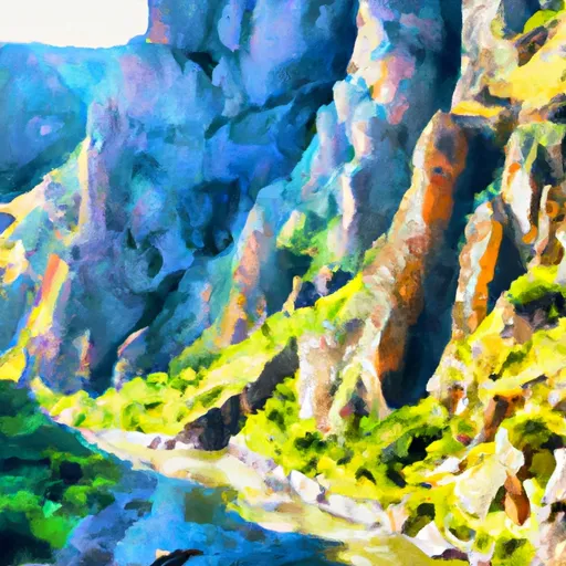
The Painted Wall To The Black Canyon Gunnison National Monument-Gunnison Gorge Wilderness Boundary
One of the most challenging rapids in this stretch is the "Golf Hole," a Class V rapid with a narrow chute and a large hole at the bottom. Other notable rapids include "Funnel Falls" and "Hole in the Wall." It is important for visitors to be aware of the specific river rapids and obstacles in this area before attempting the run.
There are specific regulations in place for the Whitewater River Run. Visitors must obtain a permit to access the Gunnison Gorge Wilderness, and there is a limit on the number of permits available each day. Additionally, visitors must adhere to Leave No Trace principles and pack out all trash and waste. It is also important to note that there are no commercial outfitters operating in this section of the river, so visitors must bring their own equipment or hire a private guide.
Overall, the Whitewater River Run from The Painted Wall to The Black Canyon Gunnison National Monument-Gunnison Gorge Wilderness Boundary is a challenging and rewarding experience for experienced paddlers. It is important for visitors to be aware of the specific regulations and rapids in this area before attempting the run.
Plan your run down to the hour
Same weather feed Snoflo's iOS app uses -- updated continuously from NOAA / yr.no. Watch the precipitation column on the meteogram; rain ahead of a run typically lifts flows 12-48 hours later depending on the basin.
Next 5 days, hour by hour
Temperature line with weather symbols on top, snow + rain accumulation as columns, humidity as a dotted line.
5-day forecast table
Every 3 hours, broken out across temperature, snow, rain, humidity, and wind. Each cell is colour-coded relative to the column min/max.
| Time | Condition | Temp (°F) | Snow (in) | Rain (in) | Humidity (%) | Wind (mps) | Wind dir |
|---|---|---|---|---|---|---|---|
| Loading detailed forecast… | |||||||
15-day temperature & precipitation
Daily temperatures, snow, and rain projected over the next two weeks -- the upstream story that drives next week's flows.
Regional streamflow levels
USGS streamgauges around The Painted Wall To The Black Canyon Gunnison National Monument-Gunnison Gorge Wilderness Boundary -- useful for spotting upstream pulses and gauging which tributary is contributing what.
| Streamgauge | Discharge | View |
|---|---|---|
| Gunnison River Below Gunnison Tunnel | 261 cfs | → |
| Smith Fork Near Lazear | · | → |
| Cimarron River Bl Squaw Creek | 14 cfs | → |
| N.F. Gunnison R Blw Leroux Cr | 47 cfs | → |
| North Fk Gunnison River Above Mouth Nr Lazear | 47 cfs | → |
| Uncompahgre River At Colona | 96 cfs | → |
Plan a longer trip
The closest boat launches, other paddle runs, and campgrounds so a day on the water can grow into a full weekend.
Boat launches
Other river runs
- Gunnison Gorge
- The Southern Boundary Of The Black Canyon Gunnison National Monument To The Painted Wall
- Curecanti National Recreation Area Boundary To High Water Line Of Morrow Point Reservoir
- Gunnison River Segment 2
Campgrounds
- North Rim Campground
- North Rim - Gunnison National Park
- South Rim Campground
- South Rim - Gunnison National Park
- East Portal Campground
- East Portal - Curecanti National Rec Area
Fishing spots
- Gould Reservoir
- Crawford Reservoir
- Crystal Reservoir
- Chipeta Lakes Swa
- Morrow Point Reservoir
- Sweitzer Lake
Whitewater safety
- Check the flow before you run
- Use the linked-gauge card and Regional Flow panel above. Class ratings change with flow -- a Class III at low water can become Class IV+ at high water.
- Know your skill ceiling
- Pick runs comfortably below your ceiling. Cold-water and big-water runs raise the consequences of any mistake.
- Wear the right gear
- Helmet, PFD, drysuit / wetsuit when water is below 60°F. Throw bag, knife, and whistle on your person, not in the boat.
- Scout, set safety, and run with a team
- Scout new rapids on foot, set safety with throw bags above the consequence pool, and run with at least one other competent paddler.
- Respect the river
- Strainers, undercuts, low-head dams, and wood can kill at any class rating. When in doubt, portage.
Set push alerts in the Snoflo app
Save The Painted Wall To The Black Canyon Gunnison National Monument-Gunnison Gorge Wilderness Boundary as a favorite, set a discharge threshold (e.g. "alert me when flow hits 600 cfs"), and the iOS app pushes the moment the linked gauge crosses.
About The Painted Wall To The Black Canyon Gunnison National Monument-Gunnison Gorge Wilderness Boundary
What's the optimal flow for The Painted Wall To The Black Canyon Gunnison National Monument-Gunnison Gorge Wilderness Boundary?
The optimal flow depends on the section and the craft. Check the Run Details panel for the linked gauge and current status.
How fresh is the cfs reading on this page?
The linked USGS streamgauge reports continuously (every 15 minutes); Snoflo refreshes throughout the day. Hover the streamflow sparkline to read individual datapoints.
What's the whitewater class?
See the Run Details panel for the class rating Snoflo tracks for this run. Class ratings change with flow -- a Class III at low water can become Class IV in high water.
Where do I put in / take out?
Tap Directions in the hero above to open driving directions to the put-in. For shuttle planning, check the Nearby Boat Launches panel and the river run operator's site.
Can I get alerts when flows hit the optimal range?
Yes -- alerts are managed in the Snoflo iOS app. Favorite this run, set a discharge threshold, and you'll get a push the moment the gauge crosses.
Other runs near here
Snoflo-tracked paddle runs within driving distance of The Painted Wall To The Black Canyon Gunnison National Monument-Gunnison Gorge Wilderness Boundary.