Headwaters To Rio San Antonio River Run
Community Reviews
Been here? Share the conditions.
Reviews, ratings & photos are added in the free Snoflo iOS app — rate a spot, tag the conditions, and your visit is verified by location. Add or manage your reviews from the app.
Headwaters To Rio San Antonio
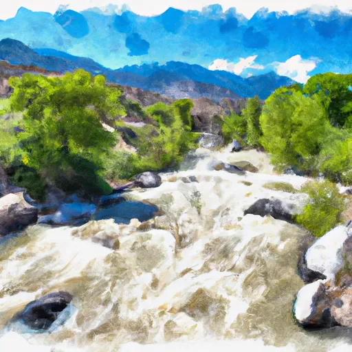
This section is rated as Class III to IV, with several challenging rapids and obstacles along the way. The total segment mileage for this run is around 10 miles, starting at the headwaters of the river and ending at the confluence with the Rio San Antonio.
Some of the most notable rapids and obstacles on this section include Staircase, Corkscrew, Eye of the Needle, and Hell Hole. These rapids offer a mix of technical maneuvers and fast-paced drops, making for an exciting and adrenaline-filled ride.
When planning a trip to this section of the Whitewater River, it's important to note that there are specific regulations in place to protect the area's natural resources. This includes restrictions on camping, fishing, and hunting in certain areas, as well as guidelines for responsible river use and safety. It's essential to check with local authorities and obtain any necessary permits before embarking on this challenging whitewater adventure.
Plan your run down to the hour
Same weather feed Snoflo's iOS app uses -- updated continuously from NOAA / yr.no. Watch the precipitation column on the meteogram; rain ahead of a run typically lifts flows 12-48 hours later depending on the basin.
Next 5 days, hour by hour
Temperature line with weather symbols on top, snow + rain accumulation as columns, humidity as a dotted line.
5-day forecast table
Every 3 hours, broken out across temperature, snow, rain, humidity, and wind. Each cell is colour-coded relative to the column min/max.
| Time | Condition | Temp (°F) | Snow (in) | Rain (in) | Humidity (%) | Wind (mps) | Wind dir |
|---|---|---|---|---|---|---|---|
| Loading detailed forecast… | |||||||
15-day temperature & precipitation
Daily temperatures, snow, and rain projected over the next two weeks -- the upstream story that drives next week's flows.
Regional streamflow levels
USGS streamgauges around Headwaters To Rio San Antonio -- useful for spotting upstream pulses and gauging which tributary is contributing what.
| Streamgauge | Discharge | View |
|---|---|---|
| Conejos River Near Mogote | 49 cfs | → |
| Rio Chama Near La Puente | 21 cfs | → |
| La Jara Creek At Gallegos Ranch | 3 cfs | → |
| Navajo R At Banded Peak Ranch | 25 cfs | → |
| Rio Chama Below El Vado Dam | 103 cfs | → |
| Navajo River Bl Oso Diversion Dam Nr Chromo | 31 cfs | → |
Plan a longer trip
The closest boat launches, other paddle runs, and campgrounds so a day on the water can grow into a full weekend.
Other river runs
- Headwaters To Private Land Boundary
- Rio Nutritas To Stewart Meadows
- Hopewell Lake To Nf Boundary
- Headwaters To Nf Boundary
Campgrounds
- Lagunitas
- Upper Lagunitas / Lower Lagunitas Campgrounds
- Lower Lagunitas
- Upper Lagunitas
- Cruces Basin Campground
- Hopewell Lake Campground
Whitewater safety
- Check the flow before you run
- Use the linked-gauge card and Regional Flow panel above. Class ratings change with flow -- a Class III at low water can become Class IV+ at high water.
- Know your skill ceiling
- Pick runs comfortably below your ceiling. Cold-water and big-water runs raise the consequences of any mistake.
- Wear the right gear
- Helmet, PFD, drysuit / wetsuit when water is below 60°F. Throw bag, knife, and whistle on your person, not in the boat.
- Scout, set safety, and run with a team
- Scout new rapids on foot, set safety with throw bags above the consequence pool, and run with at least one other competent paddler.
- Respect the river
- Strainers, undercuts, low-head dams, and wood can kill at any class rating. When in doubt, portage.
Set push alerts in the Snoflo app
Save Headwaters To Rio San Antonio as a favorite, set a discharge threshold (e.g. "alert me when flow hits 600 cfs"), and the iOS app pushes the moment the linked gauge crosses.
About Headwaters To Rio San Antonio
What's the optimal flow for Headwaters To Rio San Antonio?
The optimal flow depends on the section and the craft. Check the Run Details panel for the linked gauge and current status.
How fresh is the cfs reading on this page?
The linked USGS streamgauge reports continuously (every 15 minutes); Snoflo refreshes throughout the day. Hover the streamflow sparkline to read individual datapoints.
What's the whitewater class?
See the Run Details panel for the class rating Snoflo tracks for this run. Class ratings change with flow -- a Class III at low water can become Class IV in high water.
Where do I put in / take out?
Tap Directions in the hero above to open driving directions to the put-in. For shuttle planning, check the Nearby Boat Launches panel and the river run operator's site.
Can I get alerts when flows hit the optimal range?
Yes -- alerts are managed in the Snoflo iOS app. Favorite this run, set a discharge threshold, and you'll get a push the moment the gauge crosses.
Other runs near here
Snoflo-tracked paddle runs within driving distance of Headwaters To Rio San Antonio.