Headwaters To Holy Cross Wilderness Boundary River Run
Community Reviews
Been here? Share the conditions.
Reviews, ratings & photos are added in the free Snoflo iOS app — rate a spot, tag the conditions, and your visit is verified by location. Add or manage your reviews from the app.
Headwaters To Holy Cross Wilderness Boundary
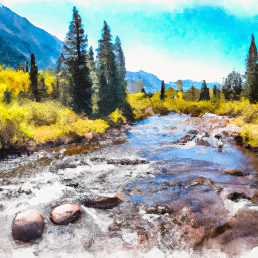
Some of the more notable rapids on this stretch of the Whitewater River include Corkscrew, Guide's Revenge, and Sledgehammer. These rapids feature technical maneuvers and require precise navigation by the rafter. Other obstacles on this run include rocks, drops, and narrow channels.
In terms of regulations, the Whitewater River is managed by the Bureau of Land Management, which requires all rafters to obtain a permit before launching. Additionally, all rafters are required to wear a personal flotation device and follow Leave No Trace principles to minimize the impact on the environment.
Overall, the Headwaters To Holy Cross Wilderness Boundary run on the Whitewater River in Colorado offers a thrilling and challenging experience for rafters who are looking for a technical and scenic whitewater adventure.
Plan your run down to the hour
Same weather feed Snoflo's iOS app uses -- updated continuously from NOAA / yr.no. Watch the precipitation column on the meteogram; rain ahead of a run typically lifts flows 12-48 hours later depending on the basin.
Next 5 days, hour by hour
Temperature line with weather symbols on top, snow + rain accumulation as columns, humidity as a dotted line.
5-day forecast table
Every 3 hours, broken out across temperature, snow, rain, humidity, and wind. Each cell is colour-coded relative to the column min/max.
| Time | Condition | Temp (°F) | Snow (in) | Rain (in) | Humidity (%) | Wind (mps) | Wind dir |
|---|---|---|---|---|---|---|---|
| Loading detailed forecast… | |||||||
15-day temperature & precipitation
Daily temperatures, snow, and rain projected over the next two weeks -- the upstream story that drives next week's flows.
Regional streamflow levels
USGS streamgauges around Headwaters To Holy Cross Wilderness Boundary -- useful for spotting upstream pulses and gauging which tributary is contributing what.
| Streamgauge | Discharge | View |
|---|---|---|
| Eagle River Near Minturn | 42 cfs | → |
| Cross Creek Near Minturn | 17 cfs | → |
| Eagle River At Red Cliff | 8 cfs | → |
| Homestake Creek At Gold Park | 21 cfs | → |
| Gore Creek At Mouth | 24 cfs | → |
| Missouri Creek Near Gold Park | 4 cfs | → |
Plan a longer trip
The closest boat launches, other paddle runs, and campgrounds so a day on the water can grow into a full weekend.
Boat launches
- Homestake Reservoir Boat Ramp Day Use Area
- Eagle Valley Trail Avon
- Sylvan Lake State Park
- Turquoise Lake Trail Lake County
- Matchless Boating Site
Other river runs
- Dowd Chute
- Riverbend To Edwards (Upper Eagle)
- Avon Whitewater Park
- Lower Eagle (Edwards Water Plant To Eagle)
Campgrounds
Fishing spots
- Kiln Creek
- Nottingham Lake
- Camp Hale Pond Fishing Pier
- Homestake Reservoir
- Black Lakes (Vail)
- Sylvan Lake
Parks
Whitewater safety
- Check the flow before you run
- Use the linked-gauge card and Regional Flow panel above. Class ratings change with flow -- a Class III at low water can become Class IV+ at high water.
- Know your skill ceiling
- Pick runs comfortably below your ceiling. Cold-water and big-water runs raise the consequences of any mistake.
- Wear the right gear
- Helmet, PFD, drysuit / wetsuit when water is below 60°F. Throw bag, knife, and whistle on your person, not in the boat.
- Scout, set safety, and run with a team
- Scout new rapids on foot, set safety with throw bags above the consequence pool, and run with at least one other competent paddler.
- Respect the river
- Strainers, undercuts, low-head dams, and wood can kill at any class rating. When in doubt, portage.
Set push alerts in the Snoflo app
Save Headwaters To Holy Cross Wilderness Boundary as a favorite, set a discharge threshold (e.g. "alert me when flow hits 600 cfs"), and the iOS app pushes the moment the linked gauge crosses.
About Headwaters To Holy Cross Wilderness Boundary
What's the optimal flow for Headwaters To Holy Cross Wilderness Boundary?
The optimal flow depends on the section and the craft. Check the Run Details panel for the linked gauge and current status.
How fresh is the cfs reading on this page?
The linked USGS streamgauge reports continuously (every 15 minutes); Snoflo refreshes throughout the day. Hover the streamflow sparkline to read individual datapoints.
What's the whitewater class?
See the Run Details panel for the class rating Snoflo tracks for this run. Class ratings change with flow -- a Class III at low water can become Class IV in high water.
Where do I put in / take out?
Tap Directions in the hero above to open driving directions to the put-in. For shuttle planning, check the Nearby Boat Launches panel and the river run operator's site.
Can I get alerts when flows hit the optimal range?
Yes -- alerts are managed in the Snoflo iOS app. Favorite this run, set a discharge threshold, and you'll get a push the moment the gauge crosses.
Other runs near here
Snoflo-tracked paddle runs within driving distance of Headwaters To Holy Cross Wilderness Boundary.