Little High Creek River Run
Community Reviews
Been here? Share the conditions.
Reviews, ratings & photos are added in the free Snoflo iOS app — rate a spot, tag the conditions, and your visit is verified by location. Add or manage your reviews from the app.
Little High Creek
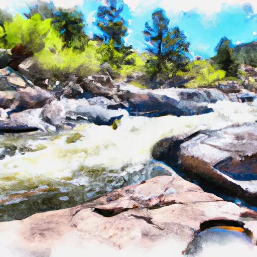
The segment mileage for Little High Creek is 6.5 miles, beginning at the wilderness boundary and ending at the confluence with the Piedra River. The river features several challenging rapids, including the Class IV "S-Turn" and "Mankiller," which require expert paddling skills and precise maneuvering. Other notable obstacles include steep drops, narrow chutes, and tight turns.
There are specific regulations that apply to the Little High Creek area, designed to protect the natural environment and ensure the safety of visitors. For example, all paddlers must wear personal flotation devices (PFDs) at all times while on the river, and they must also follow Leave No Trace principles to minimize their impact on the surrounding wilderness. Additionally, there is a strict "pack it in, pack it out" policy in place, requiring visitors to carry out all trash and waste produced during their trip.
Overall, Little High Creek is an exciting and challenging whitewater river run that offers a thrilling adventure for experienced paddlers. However, visitors should be aware of the specific regulations and safety guidelines in place to ensure a safe and enjoyable experience for all.
Plan your run down to the hour
Same weather feed Snoflo's iOS app uses -- updated continuously from NOAA / yr.no. Watch the precipitation column on the meteogram; rain ahead of a run typically lifts flows 12-48 hours later depending on the basin.
Next 5 days, hour by hour
Temperature line with weather symbols on top, snow + rain accumulation as columns, humidity as a dotted line.
5-day forecast table
Every 3 hours, broken out across temperature, snow, rain, humidity, and wind. Each cell is colour-coded relative to the column min/max.
| Time | Condition | Temp (°F) | Snow (in) | Rain (in) | Humidity (%) | Wind (mps) | Wind dir |
|---|---|---|---|---|---|---|---|
| Loading detailed forecast… | |||||||
15-day temperature & precipitation
Daily temperatures, snow, and rain projected over the next two weeks -- the upstream story that drives next week's flows.
Regional streamflow levels
USGS streamgauges around Little High Creek -- useful for spotting upstream pulses and gauging which tributary is contributing what.
| Streamgauge | Discharge | View |
|---|---|---|
| Fourmile Creek Below Cripple Creek Near Victor | 1 cfs | → |
| Arkansas River At Parkdale | 239 cfs | → |
| South Platte River Near Lake George | 105 cfs | → |
| Beaver Cr Abv Upper Beaver Cemetery Nr Penrose | 5 cfs | → |
| Arkansas River At Canon City | 205 cfs | → |
| Fountain Creek At Cascade | 68 cfs | → |
Plan a longer trip
The closest boat launches, other paddle runs, and campgrounds so a day on the water can grow into a full weekend.
Boat launches
- Skagway Road Teller County
- Forest Road 96.I Park County
- Arkansas Headwaters Recreation Area
- Ahra - Parkdale Rec Site
- Thirtynine Mile Road Park County
Other river runs
Campgrounds
- The Bank Campground Campsite A-13
- The Bank Campground Campsite A-12
- The Bank Campground Campsite A-10
- The Bank Campground Accessible Campsite A-11
- The Bank Campground Campsite A-9
- The Bank Campground Campsite A-8
Fishing spots
- Skaguay Reservoir
- Mason Reservoir
- Mcreynolds Reservoir
- Rosemont Reservoir
- North Catamount Reservoir
- South Catamount Reservoir
Parks
Whitewater safety
- Check the flow before you run
- Use the linked-gauge card and Regional Flow panel above. Class ratings change with flow -- a Class III at low water can become Class IV+ at high water.
- Know your skill ceiling
- Pick runs comfortably below your ceiling. Cold-water and big-water runs raise the consequences of any mistake.
- Wear the right gear
- Helmet, PFD, drysuit / wetsuit when water is below 60°F. Throw bag, knife, and whistle on your person, not in the boat.
- Scout, set safety, and run with a team
- Scout new rapids on foot, set safety with throw bags above the consequence pool, and run with at least one other competent paddler.
- Respect the river
- Strainers, undercuts, low-head dams, and wood can kill at any class rating. When in doubt, portage.
Set push alerts in the Snoflo app
Save Little High Creek as a favorite, set a discharge threshold (e.g. "alert me when flow hits 600 cfs"), and the iOS app pushes the moment the linked gauge crosses.
About Little High Creek
What's the optimal flow for Little High Creek?
The optimal flow depends on the section and the craft. Check the Run Details panel for the linked gauge and current status.
How fresh is the cfs reading on this page?
The linked USGS streamgauge reports continuously (every 15 minutes); Snoflo refreshes throughout the day. Hover the streamflow sparkline to read individual datapoints.
What's the whitewater class?
See the Run Details panel for the class rating Snoflo tracks for this run. Class ratings change with flow -- a Class III at low water can become Class IV in high water.
Where do I put in / take out?
Tap Directions in the hero above to open driving directions to the put-in. For shuttle planning, check the Nearby Boat Launches panel and the river run operator's site.
Can I get alerts when flows hit the optimal range?
Yes -- alerts are managed in the Snoflo iOS app. Favorite this run, set a discharge threshold, and you'll get a push the moment the gauge crosses.
Other runs near here
Snoflo-tracked paddle runs within driving distance of Little High Creek.