Mineral Creek River Run
Community Reviews
Been here? Share the conditions.
Reviews, ratings & photos are added in the free Snoflo iOS app — rate a spot, tag the conditions, and your visit is verified by location. Add or manage your reviews from the app.
Mineral Creek
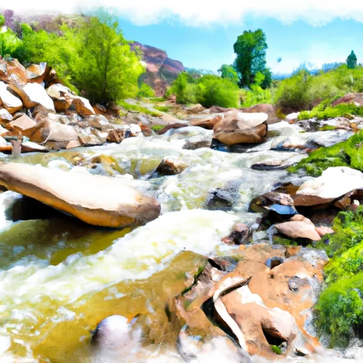
The segment mileage of Mineral Creek is approximately 5 miles, with the run starting near the town of Silverton and ending at the confluence with the Animas River. Along the way, rafters will encounter several notable rapids, including "Pinball," "Rock Drop," "Screaming Left," and "Pig Falls."
Rafters should be aware of specific regulations for the Mineral Creek area. The San Juan National Forest requires all boaters to obtain a permit for river use, which can be obtained through their website. Additionally, there are restrictions on the use of motorized watercraft and drones in the area.
Overall, Mineral Creek offers an exciting and challenging whitewater rafting experience for intermediate and advanced paddlers. As with any river run, it is important to have appropriate gear, training, and safety precautions in place before embarking on the journey.
Plan your run down to the hour
Same weather feed Snoflo's iOS app uses -- updated continuously from NOAA / yr.no. Watch the precipitation column on the meteogram; rain ahead of a run typically lifts flows 12-48 hours later depending on the basin.
Next 5 days, hour by hour
Temperature line with weather symbols on top, snow + rain accumulation as columns, humidity as a dotted line.
5-day forecast table
Every 3 hours, broken out across temperature, snow, rain, humidity, and wind. Each cell is colour-coded relative to the column min/max.
| Time | Condition | Temp (°F) | Snow (in) | Rain (in) | Humidity (%) | Wind (mps) | Wind dir |
|---|---|---|---|---|---|---|---|
| Loading detailed forecast… | |||||||
15-day temperature & precipitation
Daily temperatures, snow, and rain projected over the next two weeks -- the upstream story that drives next week's flows.
Regional streamflow levels
USGS streamgauges around Mineral Creek -- useful for spotting upstream pulses and gauging which tributary is contributing what.
| Streamgauge | Discharge | View |
|---|---|---|
| Cement Creek At Silverton | 19 cfs | → |
| Animas River At Silverton | 52 cfs | → |
| Mineral Creek At Silverton | 74 cfs | → |
| Animas River Below Silverton | 159 cfs | → |
| Animas River At Howardsville | 39 cfs | → |
| South Fork San Miguel River Near Ophir | 34 cfs | → |
Plan a longer trip
The closest boat launches, other paddle runs, and campgrounds so a day on the water can grow into a full weekend.
Other river runs
- South Mineral Creek
- Animas River
- San Miguel River Segment 1
- Saltado Creek
- Rincon La Osa--Headwaters To Confluence With Los Pinos
Campgrounds
- Dispersed Camping Area
- Million Dollar Highway Free Campsite
- Anvil Designated Camping Area
- Kendall Designated Camping Area
- Kendall Campground
- Telluride Town Park
Fishing spots
- North Fork Animas River
- Sheep Corrals Fishing Site
- Andrews Lake Swa
- Woods Lake
- Ridgway Reservoir
- Lake San Cristobal
Whitewater safety
- Check the flow before you run
- Use the linked-gauge card and Regional Flow panel above. Class ratings change with flow -- a Class III at low water can become Class IV+ at high water.
- Know your skill ceiling
- Pick runs comfortably below your ceiling. Cold-water and big-water runs raise the consequences of any mistake.
- Wear the right gear
- Helmet, PFD, drysuit / wetsuit when water is below 60°F. Throw bag, knife, and whistle on your person, not in the boat.
- Scout, set safety, and run with a team
- Scout new rapids on foot, set safety with throw bags above the consequence pool, and run with at least one other competent paddler.
- Respect the river
- Strainers, undercuts, low-head dams, and wood can kill at any class rating. When in doubt, portage.
Set push alerts in the Snoflo app
Save Mineral Creek as a favorite, set a discharge threshold (e.g. "alert me when flow hits 600 cfs"), and the iOS app pushes the moment the linked gauge crosses.
About Mineral Creek
What's the optimal flow for Mineral Creek?
The optimal flow depends on the section and the craft. Check the Run Details panel for the linked gauge and current status.
How fresh is the cfs reading on this page?
The linked USGS streamgauge reports continuously (every 15 minutes); Snoflo refreshes throughout the day. Hover the streamflow sparkline to read individual datapoints.
What's the whitewater class?
See the Run Details panel for the class rating Snoflo tracks for this run. Class ratings change with flow -- a Class III at low water can become Class IV in high water.
Where do I put in / take out?
Tap Directions in the hero above to open driving directions to the put-in. For shuttle planning, check the Nearby Boat Launches panel and the river run operator's site.
Can I get alerts when flows hit the optimal range?
Yes -- alerts are managed in the Snoflo iOS app. Favorite this run, set a discharge threshold, and you'll get a push the moment the gauge crosses.
Other runs near here
Snoflo-tracked paddle runs within driving distance of Mineral Creek.