Dolores River - Mcphee To Bedrock Segment In Tres Rios Field Office River Run
Community Reviews
Been here? Share the conditions.
Reviews, ratings & photos are added in the free Snoflo iOS app — rate a spot, tag the conditions, and your visit is verified by location. Add or manage your reviews from the app.
Dolores River - Mcphee To Bedrock Segment In Tres Rios Field Office
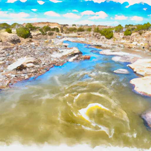
One of the main rapids on this segment is Snaggletooth, which is a class IV rapid with a large boulder in the middle of the river that requires careful navigation. There are also several other challenging rapids and obstacles throughout the run, such as Stateline, Pinball, and Razor Rock.
It is important to note that this segment of the Dolores River has specific regulations in place. Paddlers must obtain a permit from the Bureau of Land Management before embarking on the river run, and there are also restrictions on camping locations and group size. Additionally, there are regulations in place to protect the river's sensitive ecosystem, such as guidelines for waste disposal and restrictions on motorized watercraft.
Overall, the Dolores River - McPhee to Bedrock segment is an exciting and challenging river run that requires skill and experience. Paddlers must take care to follow regulations and respect the natural environment in order to preserve the beauty and safety of this popular Colorado waterway.
Plan your run down to the hour
Same weather feed Snoflo's iOS app uses -- updated continuously from NOAA / yr.no. Watch the precipitation column on the meteogram; rain ahead of a run typically lifts flows 12-48 hours later depending on the basin.
Next 5 days, hour by hour
Temperature line with weather symbols on top, snow + rain accumulation as columns, humidity as a dotted line.
5-day forecast table
Every 3 hours, broken out across temperature, snow, rain, humidity, and wind. Each cell is colour-coded relative to the column min/max.
| Time | Condition | Temp (°F) | Snow (in) | Rain (in) | Humidity (%) | Wind (mps) | Wind dir |
|---|---|---|---|---|---|---|---|
| Loading detailed forecast… | |||||||
15-day temperature & precipitation
Daily temperatures, snow, and rain projected over the next two weeks -- the upstream story that drives next week's flows.
Regional streamflow levels
USGS streamgauges around Dolores River - Mcphee To Bedrock Segment In Tres Rios Field Office -- useful for spotting upstream pulses and gauging which tributary is contributing what.
| Streamgauge | Discharge | View |
|---|---|---|
| Dolores River Near Slick Rock | · | → |
| Dolores River At Bedrock | 37 cfs | → |
| Dolores River Near Bedrock | 16 cfs | → |
| San Miguel River At Brooks Bridge Near Nucla Co | 5 cfs | → |
| San Miguel River At Uravan | 26 cfs | → |
| South Creek Above Reservoir Near Monticello | 0 cfs | → |
Plan a longer trip
The closest boat launches, other paddle runs, and campgrounds so a day on the water can grow into a full weekend.
Boat launches
Other river runs
- Bradfield Ranch Bridge To Dissappointment Creek
- Slickrock To Bedrock
- Dissappointment Creek To Little Gypsum Valley Bridge
- Dry Creek
Campgrounds
- Camping - Single
- Snaggletooth Disperse Sites
- 3 Step Hideaway
- Site Road - Aggregate
- Box Elder Rec Site
- Mountain Sheep Point Dispersed
Whitewater safety
- Check the flow before you run
- Use the linked-gauge card and Regional Flow panel above. Class ratings change with flow -- a Class III at low water can become Class IV+ at high water.
- Know your skill ceiling
- Pick runs comfortably below your ceiling. Cold-water and big-water runs raise the consequences of any mistake.
- Wear the right gear
- Helmet, PFD, drysuit / wetsuit when water is below 60°F. Throw bag, knife, and whistle on your person, not in the boat.
- Scout, set safety, and run with a team
- Scout new rapids on foot, set safety with throw bags above the consequence pool, and run with at least one other competent paddler.
- Respect the river
- Strainers, undercuts, low-head dams, and wood can kill at any class rating. When in doubt, portage.
Set push alerts in the Snoflo app
Save Dolores River - Mcphee To Bedrock Segment In Tres Rios Field Office as a favorite, set a discharge threshold (e.g. "alert me when flow hits 600 cfs"), and the iOS app pushes the moment the linked gauge crosses.
About Dolores River - Mcphee To Bedrock Segment In Tres Rios Field Office
What's the optimal flow for Dolores River - Mcphee To Bedrock Segment In Tres Rios Field Office?
The optimal flow depends on the section and the craft. Check the Run Details panel for the linked gauge and current status.
How fresh is the cfs reading on this page?
The linked USGS streamgauge reports continuously (every 15 minutes); Snoflo refreshes throughout the day. Hover the streamflow sparkline to read individual datapoints.
What's the whitewater class?
See the Run Details panel for the class rating Snoflo tracks for this run. Class ratings change with flow -- a Class III at low water can become Class IV in high water.
Where do I put in / take out?
Tap Directions in the hero above to open driving directions to the put-in. For shuttle planning, check the Nearby Boat Launches panel and the river run operator's site.
Can I get alerts when flows hit the optimal range?
Yes -- alerts are managed in the Snoflo iOS app. Favorite this run, set a discharge threshold, and you'll get a push the moment the gauge crosses.
Other runs near here
Snoflo-tracked paddle runs within driving distance of Dolores River - Mcphee To Bedrock Segment In Tres Rios Field Office.